Facts about Djibouti
Explore Djibouti from the capital’s port streets to Tadjourah and Obock, the salt shores of Assal and the limestone chimneys of Abbe. Ten illustrated topics connect the Afar rift with languages, history, food and everyday life.
- Capital
- Djibouti City
- Currency
- Djiboutian franc (DJF)
- Official languages
- Arabic · French
- National languages
- Somali · Afar
- Independence
- 27 June 1977
- Lowest point
- Lake Assal · about −155 m
Djibouti · 0 of 20 rounds passed
Two timed rounds per topic, 20 seconds a question
Djibouti City anchors the southern shore of the Gulf of Tadjoura. Arta rises inland, Ali Sabieh and Dikhil orient the south, and Tadjourah and Obock introduce the northern coast. Randa, Dorra and Balho connect the mountains and northern interior with the western frontier at Galafi.
Place sixteen cities and towns, find eight complete waters and explore twelve landscape and heritage sights. The Awash runs through Ethiopia to shared Lake Abbe; marine waters continue through Bab el Mandeb into the full Red Sea and Gulf of Aden. Somali, French and Arabic lessons offer three starting points within a country where Afar is also central.
Geography of Djibouti
Salt lakes, volcanic rifts and a coast linking Africa with Arabia.
- Where is Djibouti?
- In the Horn of Africa, between Eritrea, Ethiopia, Somalia and the waters connecting the Red Sea with the Gulf of Aden.
- Are Lake Assal and Lake Abbe the same lake?
- No. Assal is a hypersaline lake below sea level within Djibouti; Abbe is shared with Ethiopia and receives the Awash.
- Does the Awash reach the sea?
- No. It ends in the Lake Abbe basin on the Ethiopia–Djibouti frontier.
More about Djibouti: geography
Djibouti lies in the Horn of Africa at the southern entrance to the Red Sea. It borders Eritrea, Ethiopia and Somalia, along a frontier administered by Somaliland. The Gulf of Tadjoura reaches inland from the Gulf of Aden, ending in the narrow-necked Ghoubbet al-Kharab. Across Bab el Mandeb lies Yemen. The capital, Djibouti City, stands on the southern side of the gulf.
The Afar Depression brings together active rifting, lava fields and very dry lowlands. Lake Assal lies about 155 metres below sea level, the lowest exposed point in Africa, and is extremely saline. Lake Abbe is a separate, shared lake on the Ethiopian border. The Awash flows through Ethiopia to this inland basin, without reaching the sea. Its full course, the shared lakes and the connected marine waters can be followed beyond Djibouti on the waters map.
History of Djibouti
Older caravan ports, French colonial rule and independence in 1977.
- When did Djibouti become independent?
- On 27 June 1977.
- What was the territory called from 1967?
- The French Territory of the Afars and the Issas.
- Was there only one peace agreement?
- No. Agreements in 1994 and 2001 addressed different stages and factions of the conflict.
More about Djibouti: history
Long before the modern republic, Afar and Somali communities connected inland pastoral and caravan routes with ports such as Tadjourah. Red Sea and Gulf of Aden trade linked these shores with Arabia. French expansion began with treaties around Obock in 1862. Djibouti City was founded in 1888 and became the colonial capital. The railway to Addis Ababa strengthened its role as a gateway to the Ethiopian highlands.
The colony was known as French Somaliland and, from 1967, the French Territory of the Afars and the Issas. Djibouti became independent on 27 June 1977, with Hassan Gouled Aptidon as its first president. A civil conflict involving the government and the FRUD rebellion began in 1991. Peace agreements in 1994 and 2001 involved different stages and factions; describing the conflict as simply one ethnic group against another misses its political history.
Djibouti’s languages
Somali and Afar in daily life; Arabic and French in official institutions.
- Which languages are official?
- Arabic and French.
- Are Somali and Afar varieties of Arabic?
- No. Somali and Afar are Cushitic languages; Arabic is Semitic.
- Which languages can I begin here?
- Somali, French and Arabic. Afar is important in Djibouti but has no dedicated Worldly course yet.
More about Djibouti: language
Arabic and French are Djibouti’s official languages. Somali and Afar are widely spoken national languages and belong to the Cushitic branch of the Afroasiatic family. They are distinct languages, with communities and family connections extending across national borders. Arabic belongs to the Semitic branch of Afroasiatic, while French is a Romance language.
French has an important role in public administration and schooling; Arabic connects religious life, education and wider regional communication. Both Somali and Afar use Latin-based writing systems, alongside long oral traditions. Language use varies by household and setting. Worldly offers Somali, French and Arabic courses as starting points for this guide; it does not yet offer an Afar course. Those choices do not imply that all Djiboutians speak the same languages.
Culture of Djibouti
Poetry, hospitality and performance shaped by pastoral and port histories.
- Why is poetry important?
- Oral poetry carries memory, commentary and performance across generations.
- What is an aqal?
- A portable, mat-covered dwelling associated with Somali pastoral households.
- Is there one uniform Djiboutian culture?
- No. Afar, Somali and other communities contribute distinct and overlapping traditions.
More about Djibouti: culture
Spoken poetry, song and dance preserve memory, offer commentary and mark celebrations. Afar and Somali traditions share a regional setting while retaining distinct languages and forms. Woven mats, baskets and portable household objects reflect knowledge developed through pastoral life. The mat-covered aqal is associated with Somali mobile households; urban homes and contemporary work are equally part of the country’s cultural landscape.
Islam shapes many religious calendars, family occasions and daily practices. Hospitality can centre on conversation, coffee or spiced tea. Clothing varies with community, occasion and personal choice: the macawis wrap and the flowing dirac are familiar examples rather than universal uniforms. Djibouti’s port connections also bring Yemeni, other Arab, Ethiopian, Indian and French influences. Neither a single dance nor a single social custom represents every resident.
Economy of Djibouti
Ports, railways and services connect a small country with a large hinterland.
- What connects Djibouti’s ports to Ethiopia?
- Road and rail corridors carry imports and exports between the coast and Ethiopia’s inland economy.
- What is the currency?
- The Djiboutian franc, DJF.
- Why is domestic farming limited?
- Aridity, scarce water and limited cultivable land constrain crop production.
More about Djibouti: economy
Port operations, transport and logistics are central to Djibouti’s economy. The corridor to landlocked Ethiopia links ships with roads, railways, warehouses and inland markets. Doraleh’s port facilities form part of this system alongside older waterfront infrastructure. The national currency is the Djiboutian franc, with code DJF. Trade routes make the country economically important beyond the size of its domestic market.
Dry conditions and limited cultivable land constrain crop production, and imported food plays a large role. Pastoral livelihoods, fishing, commerce and public services also matter. Foreign military facilities bring leases and related activity, while international investment has helped finance major infrastructure. These connections also expose households and businesses to shipping disruption, regional tensions and debt pressures. Port growth does not automatically mean equal access to jobs, water or public services.
Politics of Djibouti
A republic with regional diplomacy and a major strategic location.
- What does IGAD stand for?
- Intergovernmental Authority on Development, a regional organisation headquartered in Djibouti.
- What is Djibouti’s state religion?
- Islam; the constitution also says the state respects all beliefs.
- Why is Bab el Mandeb politically important?
- It connects the Red Sea and Gulf of Aden along an important international shipping route.
More about Djibouti: politics
Djibouti’s constitution establishes a republic with a president, government and elected national representatives. Islam is the state religion, while constitutional provisions recognise equality and freedom of belief. Constitutional rules and the way political power operates are different subjects: formal institutions alone do not describe the experience of political participation. The ruling RPP and its allied coalition have dominated national politics for decades.
The country hosts the headquarters of the Intergovernmental Authority on Development, or IGAD, and belongs to the African Union and Arab League. Its location near Bab el Mandeb gives maritime security and relations with neighbouring countries particular importance. Military facilities operated by several foreign powers reflect that strategic role. Learning about these relationships need not reduce Djibouti to a base for outsiders; residents’ work, rights and political choices remain part of the story.
Nature & Wildlife of Djibouti
Relict mountain forest, coral habitats and a landscape still being pulled apart.
- What makes the Day Forest distinctive?
- It is a remnant mountain woodland in an otherwise largely arid country.
- Are whale sharks whales?
- No. They are large, filter-feeding sharks.
- What habitats occur around Moucha and Maskali?
- Coral reefs, mangroves and associated marine and coastal wildlife.
More about Djibouti: nature & wildlife
The Day Forest in the Goda Mountains preserves a rare woodland environment above the hot lowlands. Juniper and other trees support habitats associated with the threatened Djibouti francolin. Forest degradation and grazing pressure make conservation important. Elsewhere, sparse vegetation, seasonal watercourses and pastoral rangelands show how plants, animals and people live with limited rainfall.
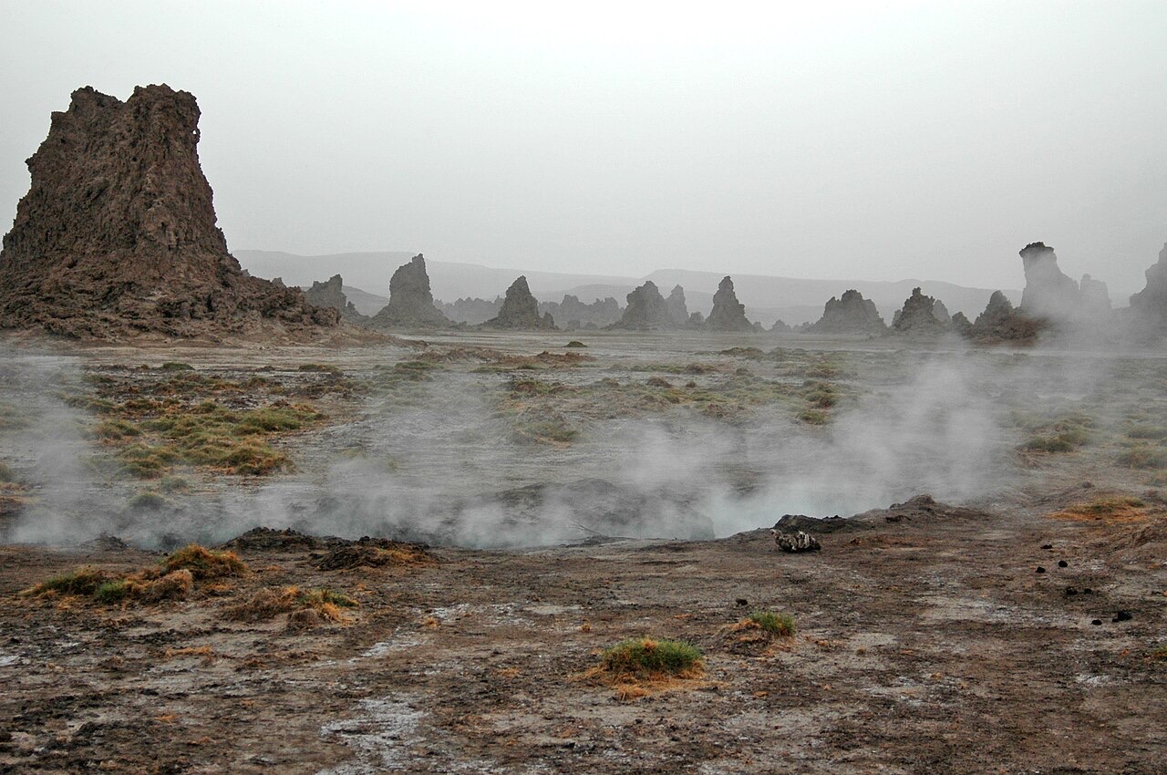
Coral reefs and mangroves around Moucha and Maskali contrast with the salt and limestone landscapes inland. Whale sharks, which are fish rather than whales, gather seasonally in coastal feeding areas; sightings depend on conditions. Lake Abbe’s hot springs and limestone chimneys and Ardoukoba’s 1978 eruption reveal the geology of the Afar rift. These environments are living habitats, not empty scenery, and their boundaries are wider than a single sight pin.
Food & Cuisine of Djibouti
Spiced rice, flatbreads, soups and fish connect pastoral and maritime tables.
- What is skoudehkaris?
- A spiced rice-and-meat dish associated with Djibouti.
- What is fah-fah?
- A soup or stew made with meat and vegetables.
- What is basbaas?
- A chilli-based condiment, with recipes varying between cooks.
More about Djibouti: food & cuisine
Skoudehkaris is a spiced rice dish cooked with meat, often lamb or beef, and widely associated with Djibouti. Fah-fah is a meat-and-vegetable soup or stew. Fish reflects coastal connections, while livestock traditions contribute goat and camel products. Recipes and names travel across the Horn of Africa and Arabian shores, so a familiar dish may have several local forms.
Canjeero, also known as lahoh in regional usage, is a spongy flatbread eaten at breakfast and with other meals. Baguettes reflect French influence. Samboussa pastries, spiced tea, chilli-based basbaas and sweet xalwo add other textures and flavours. Household choices depend on taste, income, season and occasion; a list of national dishes is a starting point for learning rather than a fixed menu for every home.
Landmarks of Djibouti
Salt shores, limestone chimneys, island reefs and the streets of an old port.
- Are Lake Assal and Lake Abbe inscribed World Heritage sites?
- No. They are on Djibouti’s Tentative List; tentative listing is separate from inscription.
- Where is Hamoudi Mosque?
- In the historic centre of Djibouti City.
- What do the sight pins represent?
- Selected learning locations, which may be only one part of a larger landscape or settlement.
More about Djibouti: landmarks
Lake Assal’s pale salt margins and Lake Abbe’s limestone chimneys offer two very different lake landscapes. Ardoukoba and the neighbouring lava fields connect them with the active Afar rift. The Day Forest, Grand Bara plain and Ghoubbet al-Kharab extend the picture beyond the capital. Moucha and Maskali provide island reference points at the entrance to the Gulf of Tadjoura.
In Djibouti City, Hamoudi Mosque and the historic centre tell an urban story of markets, religion and maritime exchange. Tadjourah and Obock introduce older coastal settlements. Djibouti has sites on UNESCO’s Tentative List, including Assal, Abbe, the Day Forest and the historic capital, but no inscribed World Heritage property as checked in October 2026. Tentative listing is a proposal stage, not inscription. The twelve sight pins identify learning locations within these wider places.
People & Society of Djibouti
Afar and Somali communities, urban lives and connections across the region.
- Are Issa and Somali unrelated identities?
- No. Issa is a Somali community; Somali is the wider identity in this relationship.
- Which countries are important origins for refugees in Djibouti?
- Somalia, Ethiopia and Yemen are major origins identified by UNHCR.
- Does every resident live in the capital?
- No. Djibouti City is dominant, but towns, villages and pastoral communities remain important.
More about Djibouti: people & society
Afar and Somali communities are central to Djibouti’s social history. The Issa are part of the wider Somali population; the terms are not parallel names for separate language families. Many residents live in the capital, while smaller towns and rural communities maintain distinct connections with ports, livestock routes, wells and regional markets. A nationality, a language and an ethnic identity answer different questions.
Family and commercial links extend into Ethiopia, Eritrea, Somalia, Somaliland, Yemen and diaspora communities. Djibouti also hosts refugees and asylum seekers, notably from Somalia, Ethiopia and Yemen. Ali Addeh, Holhol and Markazi near Obock are associated with refugee-hosting communities, alongside people living in urban areas. These are places where people live, study and work, rather than sightseeing stops. Water, schooling and employment matter to both displaced families and their hosts.