Facts about Algeria
Explore Algeria from Mediterranean harbours and mountain villages to the sandstone towers of Tassili n’Ajjer. Find the Casbah of Algiers, Roman cities and Saharan oases, then discover the histories, languages and daily life of Africa’s largest country by area.
- Capital
- Algiers
- Area
- 2,381,741 km²
- Currency
- Algerian dinar (DZD)
- Official languages
- Arabic and Tamazight
- Independence Day
- 5 July
- Wilayas, 2026 framework
- 69, with new divisions in transition
Algeria · 0 of 20 rounds passed
Two timed rounds per topic, 20 seconds a question
Begin in the north with Algiers and the Casbah, then choose a western route through Oran and Tlemcen or an eastern route through Constantine, Djémila and Timgad. Kabylia and the Aurès introduce mountain landscapes, while Tipasa places ancient history beside the Mediterranean. Distances are substantial, so these routes work better as separate journeys than a single checklist.
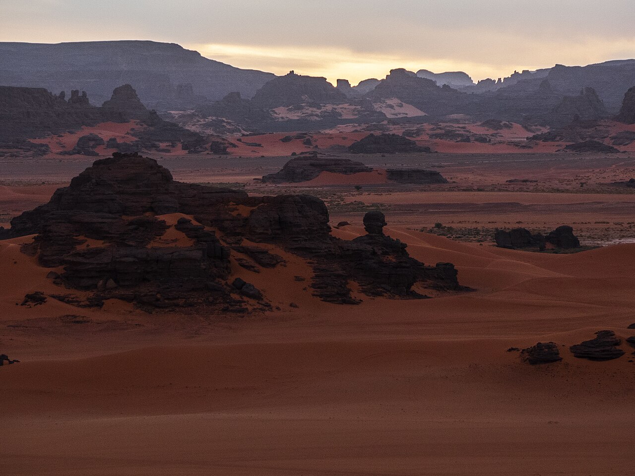
Farther south, Ghardaïa introduces the M’Zab Valley. Tamanrasset is a base for the Ahaggar, while Djanet connects with Tassili n’Ajjer and the Tadrart Rouge. Check current official travel advice and arrange permitted desert routes with an authorised local operator. This guide brings together three learning maps, fifteen sights and ten facts topics, with linked Arabic and French lessons.
Geography of Algeria
A Mediterranean north, high plateaus and an immense Saharan south.
- Where is Algeria?
- In the Maghreb region of North Africa, on the Mediterranean Sea.
- What is Algeria’s highest mountain?
- Mount Tahat in the Ahaggar, or Hoggar, massif in the southern Sahara.
- Is the Algerian Sahara all sand?
- No. Dune fields are interspersed with rocky plateaus, gravel plains and mountain massifs.
More about Algeria: geography
Algeria covers 2,381,741 square kilometres in North Africa. The Mediterranean borders its northern coast, where Algiers, Oran and Annaba connect ports with the more densely settled interior. The Tell Atlas rises behind the coast. Farther south, the High Plateaus lie between the Tell Atlas and Saharan Atlas. Kabylia occupies a mountainous part of the north, while the Aurès rises in the east.
The Sahara covers most of the country, but it is not one continuous sea of sand. Rocky plateaus and gravel plains separate dune fields such as the Grand Erg Occidental and Grand Erg Oriental. The Ahaggar, also called the Hoggar, contains Mount Tahat, Algeria’s highest summit. The Chelif drains part of the north towards the Mediterranean. Southern settlements depend on limited water supplies, including groundwater and oasis irrigation.
History of Algeria
Numidian kingdoms, Mediterranean connections and the struggle for independence.
- When did Algeria become independent?
- Algeria gained independence from France in 1962 and celebrates Independence Day on 5 July.
- When did French colonisation begin?
- The French invasion of Algiers began in 1830.
- What was Numidia?
- An ancient North African kingdom associated with rulers such as Massinissa, in territory including parts of present-day Algeria.
More about Algeria: history
Ancient Numidian kingdoms formed part of a North African world connected with Carthage and Rome. Massinissa was a major Numidian ruler. Roman-era places such as Timgad and Djémila preserve streets, public buildings and mosaics, while Tipasa records several periods of settlement beside the sea. The arrival of Islam from the seventh century was followed by successive regional dynasties. Algiers later became a centre of Ottoman-linked rule.
France invaded Algiers in 1830. Colonial expansion involved dispossession and unequal political rights, and resistance continued in different forms. The independence war began in 1954 and ended in 1962 after negotiations and the Évian agreements. Algeria celebrates independence on 5 July. The one-party era after independence and the violence of the 1990s shaped later political life. The Hirak protest movement began in 2019, calling for political change.
Languages of Algeria
Arabic and Tamazight are official, with several everyday speech traditions.
- What are Algeria’s official languages?
- Arabic and Tamazight. French is widely used in some settings but has no official-language status.
- Is Darja the same as Modern Standard Arabic?
- No. Algerian Arabic, or Darja, has its own everyday vocabulary and pronunciation.
- Does this guide teach Algerian Darja?
- The linked Arabic lessons teach Modern Standard Arabic. They are not a dedicated Darja course.
More about Algeria: language
Arabic and Tamazight are Algeria’s official languages. Algerian Arabic, often called Darja, is widely used in everyday conversation and differs from Modern Standard Arabic in pronunciation and vocabulary. Amazigh varieties include Kabyle in Kabylia, Chaoui in the Aurès and Tuareg varieties in the Sahara. These speech communities do not fit into a simple division between two uniform ethnic groups.
French is used in many professional, educational and social settings, but it is not an official language of Algeria. Language use changes with place, household and situation. The linked Arabic lessons introduce Modern Standard Arabic, rather than a dedicated Darja course. French lessons are also available. Learning a few expressions can help with conversation, while recognising that Tamazight and other community languages are part of the country’s life.
Culture of Algeria
Raï, chaabi and regional traditions connect music with everyday experience.
- Which Algerian city is associated with raï?
- Oran and the wider western Algerian region are closely associated with raï.
- What is the imzad?
- A single-string bowed instrument traditionally played by women in Tuareg communities.
- What does Yennayer celebrate?
- The Amazigh New Year, with traditions that differ between families and places.
More about Algeria: culture
Raï developed in western Algeria and is closely associated with Oran. Its songs address love, social pressures and personal freedom. Performers such as Khaled brought it to international audiences, and UNESCO recognised raï in 2022. Algiers has a strong chaabi tradition, while Constantine is associated with malouf, part of the wider Arab-Andalusian musical world. Contemporary music and film continue to reinterpret these inheritances.
Amazigh weaving, pottery and jewellery vary between communities. In the Sahara, Tuareg traditions include the imzad, a single-string bowed instrument traditionally played by women. Yennayer marks the Amazigh New Year. Weddings, religious festivals and family gatherings provide settings for music and shared meals, but customs vary widely. A living neighbourhood such as the Casbah includes ordinary homes and working workshops as well as protected monuments.
Economy of Algeria
Energy exports, northern farming and the work of a broader domestic economy.
- What currency does Algeria use?
- The Algerian dinar, with the currency code DZD.
- Why do oil and gas prices matter to Algeria?
- Hydrocarbons account for a large share of export earnings and contribute substantially to public finances.
- Where are dates grown?
- Date palms are cultivated in Saharan oases, where farming depends on carefully managed water supplies.
More about Algeria: economy
Oil and natural gas are central to Algeria’s export earnings and public finances. Hassi Messaoud is associated with oil production, while Hassi R’Mel is a major gas field. Pipelines and coastal facilities connect inland production with overseas markets. Dependence on hydrocarbons makes changes in energy prices important for the wider economy. The Algerian dinar, abbreviated DZD, is the national currency.
Northern farming produces cereals, olives and other Mediterranean crops. Oasis agriculture includes date palms, with water management central to cultivation. Ports, construction and services employ people beyond the energy sector. Developing a more varied economy is a continuing policy objective. Water scarcity, employment opportunities and the practical difficulties of connecting places over large distances all influence economic decisions. Historic crafts and tourism contribute to some local livelihoods.
Politics of Algeria
A republic, two parliamentary chambers and an evolving wilaya map.
- What are the chambers of Algeria’s parliament?
- The National People’s Assembly and the Council of the Nation.
- Why does this map show 69 wilayas?
- The April 2026 territorial law added eleven to the previous 58. The new wilayas are in a transition period through 2026, with full operation planned for January 2027.
- Is Western Sahara part of Algeria?
- No. Western Sahara is a separate disputed territory. Algeria supports the Polisario Front and hosts Sahrawi refugee camps near Tindouf.
More about Algeria: politics
Algeria is a republic with a president as head of state. Parliament has two chambers: the National People’s Assembly and the Council of the Nation. The presidency and executive institutions play a central role in government. The war of independence remains important to political identity, while public debates also concern representation, employment and the relationship between civilian institutions and the military.
Wilayas are the country’s principal administrative divisions. Law 26-06 of 4 April 2026 expanded the legal framework from 58 to 69 wilayas. The eleven new divisions have a transition period through the end of 2026, with full operation planned for January 2027. This guide’s learning map includes the 69-division framework. Algeria is a member of the African Union and Arab League. Its support for the Polisario Front is distinct from sovereignty over Western Sahara.
Nature and wildlife of Algeria
Cedar forests, coastal wetlands and the desert’s record of a wetter past.
- Are Barbary macaques apes?
- No. Barbary macaques are monkeys, even though “Barbary ape” is an older common name.
- Can it snow in Algeria?
- Yes. Northern mountain areas can receive snow, although most of the national territory is arid.
- What does Tassili’s rock art reveal?
- Its images provide evidence of past human life and animals associated with a wetter Sahara.
More about Algeria: nature & wildlife
Northern Algeria has Mediterranean forests and mountain habitats, including cedar and oak woodland. Barbary macaques occur in parts of the north, including areas around Djurdjura and Béjaïa. They are monkeys despite the older name “Barbary ape”. El Kala’s coastal wetlands support birdlife. Mountain slopes can receive snow, a sharp contrast with the arid landscapes farther south.
The Sahara supports animals adapted to heat and limited water, including the fennec fox. Sandstone formations at Tassili n’Ajjer preserve rock art that depicts animals associated with a wetter environment. These records help connect human history with long-term environmental change. Drought, wildfire and pressure on water supplies affect different parts of the country. Protected landscapes are working environments for local communities, as well as places with ecological and cultural value.
Food of Algeria
Couscous, regional breads and the varied tables of coast and oasis.
- Is couscous exclusive to Algeria?
- No. Algeria shares couscous traditions with neighbouring countries. The 2020 UNESCO inscription was submitted jointly by four countries.
- What is chorba frik?
- A soup made with cracked green wheat, with recipes varying by household and region.
- What is kesra?
- An Algerian semolina flatbread, commonly cooked on a griddle.
More about Algeria: food & cuisine
Couscous is central to many Algerian food traditions. Steamed semolina grains are served with accompaniments that change with region and occasion. UNESCO’s 2020 recognition of couscous knowledge and practices is shared by Algeria, Mauritania, Morocco and Tunisia. It recognises preparation and social traditions rather than awarding one country exclusive ownership of the dish. Coastal cooking includes fish, while inland food traditions draw on local grains and produce.
Chorba is a family of soups, with chorba frik using cracked green wheat. Rechta consists of fine noodles, and chakhchoukha uses pieces of flatbread with sauce. Kesra is a semolina flatbread. Bourek are filled pastry rolls, while makrout commonly combines semolina and a date filling. Recipes, spellings and serving customs vary. Coffee and tea are both part of social life, without one fixed preparation describing every Algerian household.
Sights and landmarks of Algeria
Roman streets, a living Casbah and settlements shaped for the desert.
- How many UNESCO World Heritage properties are in Algeria?
- Seven as of October 2026. Six are cultural properties and Tassili n’Ajjer is listed for both cultural and natural significance.
- How do Timgad and Djémila differ?
- Timgad is known for its regular Roman grid. Djémila’s plan adapted to its mountainous setting.
- What is the M’Zab Valley known for?
- Its five historic fortified settlements and architecture adapted to community life in a desert environment.
More about Algeria: landmarks
The Casbah of Algiers is a historic hillside neighbourhood with narrow lanes, traditional houses and Ottoman-period buildings. Tipasa places ancient ruins beside the Mediterranean. Timgad is known for its Roman street grid, while Djémila shows Roman planning adapted to a mountain site. Al Qal’a of Beni Hammad preserves the remains of an eleventh-century fortified capital. These places belong to different periods rather than one continuous architectural style.
The M’Zab Valley includes five historic fortified settlements associated with Ibadi communities. Tassili n’Ajjer combines prehistoric rock art with eroded sandstone formations. Both are UNESCO World Heritage properties, alongside five others in Algeria. Beyond the listed sites, Constantine’s bridges cross the Rhumel gorge and Oran’s Santa Cruz complex overlooks the city. Saharan journeys require route-specific planning and local arrangements. Heritage pins identify places to learn about, rather than guaranteeing present access.
People and daily life of Algeria
Urban communities, overlapping identities and connections across borders.
- Where do most Algerians live?
- In the north, especially in cities and towns near the Mediterranean and adjacent uplands.
- Are Arab and Amazigh identities mutually exclusive?
- No. Language, family history and regional identity overlap in many ways.
- What is Djanet associated with?
- The oasis town is a gateway to the sandstone landscapes and rock art of the Tassili region.
More about Algeria: people & society
Most Algerians live in the northern part of the country, where the largest urban areas and much of the farmland are concentrated. Algiers is the capital, while Oran, Constantine and Annaba have distinct regional roles. Arab and Amazigh identities can overlap with language, family history and locality. Kabyle, Chaoui, Mozabite and Tuareg communities are among the country’s varied social and cultural connections.
Towns in the Sahara are also contemporary places of work and family life. Ghardaïa is part of the M’Zab’s settlement network, Tamanrasset connects the Ahaggar with wider Saharan routes and Djanet is a gateway to Tassili landscapes. Migration has linked families with France and other countries. Writers including Assia Djebar and Mouloud Feraoun explored memory, language and social change. No single custom or language describes every Algerian person.