Facts about Burkina Faso
Explore Burkina Faso from Ouagadougou and the central plateau to Bobo-Dioulasso, the southwestern sandstone landscapes and the northern Sahel. Sixteen city pins, rivers across borders, heritage places and ten illustrated topics introduce the country.
- Capital
- Ouagadougou
- Area
- About 274,000 km²
- Currency
- West African CFA franc (XOF)
- Official languages
- National languages officialised by law
- Working languages
- French and English
- Independence
- 5 August 1960
Burkina Faso · 0 of 20 rounds passed
Two timed rounds per topic, 20 seconds a question
Ouagadougou anchors the central plateau, with Koudougou to the west and Kaya and Ziniaré to the northeast. Bobo-Dioulasso, Banfora and Gaoua introduce the southwest; Dédougou and Tougan lie toward the western river valleys. Ouahigouya and Dori orient the north, while Fada N’Gourma and Diapaga lead east.
The Mouhoun and Nakambé run into Ghana, while the Pendjari–Oti and Comoé connect other cross-border landscapes. Zoom out on the water map to follow their mapped courses and the Volta to the sea. The guide’s locations are for learning and do not imply safe access.
Geography of Burkina Faso
From Sahelian north to southwestern savannas and rivers.
- Where is Burkina Faso?
- In inland West Africa, bordered by six countries.
- What is the Mouhoun also called?
- The Black Volta; its waters continue into Ghana.
- Does every river in Burkina Faso drain into the Volta?
- No. The Comoé flows south into Côte d’Ivoire, while eastern tributaries also drain towards the Niger.
More about Burkina Faso: geography
Burkina Faso is a landlocked West African country bordering Mali, Niger, Benin, Togo, Ghana and Côte d’Ivoire. Ouagadougou stands on the central plateau; Bobo-Dioulasso is a major city in the southwest. Rainfall generally increases toward the southwest, while the north lies in the drier Sahel. Seasonal rain and the dry, dusty harmattan shape farming and water supplies.
The Mouhoun, Nakambé and Nazinon are also known as the Black, White and Red Volta. The Mouhoun and Nakambé continue into Ghana and Lake Volta; the Pendjari becomes the Oti and also reaches the reservoir. The Comoé flows south into Côte d’Ivoire. Our maps show available mainstems beyond the national border, including the lower Volta to the Atlantic.
History of Burkina Faso
Mossi kingdoms, colonial rule and independence.
- What was the country called at independence?
- Upper Volta.
- Who renamed it Burkina Faso in 1984?
- Thomas Sankara.
- What happened in 2014?
- A popular uprising ended Blaise Compaoré’s long presidency.
More about Burkina Faso: history
Mossi kingdoms, including Ouagadougou and Yatenga, developed political institutions and trading connections across the region. Their histories are preserved through oral traditions as well as written records. Other communities and kingdoms also shaped the area that is now Burkina Faso; present borders should not be projected onto earlier states.
France conquered the area in the late nineteenth century. Upper Volta became independent in 1960. Thomas Sankara took power in 1983 and renamed the country Burkina Faso in 1984. He was killed in a 1987 coup; Blaise Compaoré then ruled until a popular uprising in 2014. Later political transitions and armed conflict have continued to reshape public life.
Languages of Burkina Faso
Mooré, Dioula, Fulfulde and many other languages.
- What is Mooré?
- A widely spoken language associated with Mossi communities.
- Where is Dioula useful?
- It is used in trade and communication across western Burkina Faso and the region.
- What do the linked language lessons teach?
- General French; they do not represent all Burkinabè languages.
More about Burkina Faso: language
Burkina Faso is multilingual. Mooré is widely spoken in and around the central plateau; Dioula serves as a language of trade across the west and beyond the country. Fulfulde, Gourmanchéma, Bissa and many other languages are used by different communities. Language and identity do not map neatly onto one another.
A 2023 constitutional revision provides for national languages officialised by law to be official, and recognises French and English as working languages. French remains important in administration and formal education. Worldly’s linked lessons introduce general French, not the country’s full linguistic diversity.
Culture of Burkina Faso
Cinema, woven cloth, music and living traditions.
- What is FESPACO?
- A Pan-African film and television festival hosted in Ouagadougou.
- What is Faso dan fani?
- Handwoven cloth used in clothing and made in different patterns.
- Are all masks used in the same way?
- No. Their meanings and use vary between communities and occasions.
More about Burkina Faso: culture
Ouagadougou hosts FESPACO, the Pan-African Film and Television Festival, which brings filmmakers and audiences together from across Africa and its diaspora. Its leading award is the Étalon de Yennenga, named for a figure associated with Mossi founding traditions. The city also hosts the SIAO craft fair.
Faso dan fani is handwoven cloth made in many patterns and used in clothing. Music, oral histories, dance, metalwork and masks belong to varied local traditions rather than a single national style. Fibre and wooden masks have particular meanings in the communities that create and use them.
Economy of Burkina Faso
Farming, gold, cotton and trade routes.
- Which fibre crop is important for exports?
- Cotton.
- Which mineral is a major export?
- Gold, produced by industrial and artisanal mining.
- Why do regional transport corridors matter?
- Burkina Faso is landlocked and relies on neighbouring countries for access to ports.
More about Burkina Faso: economy
Many households depend on farming and livestock, growing crops such as sorghum, millet and maize. Cotton is an important cash crop, and shea products support processing and trade. Rainfall variability, land pressures and insecurity can disrupt cultivation and access to markets.
Gold mining is a major source of export revenue, with both industrial and artisanal activity. Burkina Faso uses the West African CFA franc and is landlocked, so roads and regional transport corridors matter for trade. Mining, public services, small businesses and agriculture have different benefits and environmental costs.
Politics of Burkina Faso
Institutions, regional ties and a military-led transition.
- How many regions were established in the 2025 reorganisation?
- Seventeen.
- Which countries formed the Alliance of Sahel States?
- Burkina Faso, Mali and Niger.
- When did their ECOWAS withdrawal take effect?
- January 2025.
More about Burkina Faso: politics
After a popular uprising in 2014 and subsequent elections, Burkina Faso experienced two military coups in 2022. A military-led transition continues amid violence by armed groups and displacement. Political institutions and security conditions can change, and maps do not show who controls territory.
In 2025 the government reorganised the country into 17 regions and 47 provinces, replacing the earlier 13-region arrangement. Burkina Faso, Mali and Niger formed the Alliance of Sahel States; their withdrawal from ECOWAS took effect in January 2025. Official travel advice warns against all travel to Burkina Faso.
Nature & Wildlife of Burkina Faso
Savannas, wetlands and transboundary conservation.
- What does W refer to?
- A series of bends in the Niger River.
- Which countries share W-Arly-Pendjari?
- Benin, Burkina Faso and Niger.
- What is the Mare d’Oursi?
- A northern wetland important for waterbirds.
More about Burkina Faso: nature & wildlife
Savanna, gallery forest and seasonal wetlands support a range of wildlife. The W-Arly-Pendjari complex spans Burkina Faso, Benin and Niger, with habitats for elephants and other large mammals. Its name refers to the W-shaped bends of the Niger River; the complex is a UNESCO World Heritage property.
In the north, the Mare d’Oursi is a wetland important to waterbirds. Conservation depends on local communities, livelihoods and land management as well as protected-area designation. Insecurity affects access and conservation work; animal sightings and safe entry cannot be assumed.
Food & Cuisine of Burkina Faso
Tô, sauces, rice and market ingredients.
- What is tô?
- A thick grain staple commonly served with sauce.
- What is riz gras?
- A seasoned rice dish, often prepared with vegetables and meat.
- What is dolo?
- A traditional fermented grain beer.
More about Burkina Faso: food & cuisine
Tô is a thick staple made from grains such as sorghum, millet or maize and commonly served with a savoury sauce. Ingredients vary by household and season; leaves, okra, groundnuts and other vegetables may be used in sauces. Riz gras is a seasoned rice dish often prepared with vegetables and meat.
Street and market food can include grilled chicken, sometimes called poulet bicyclette. Dolo is a traditional fermented grain beer; zoom-koom is a millet-based drink with local variations. These examples are introductions to diverse food traditions, not a single menu shared by every family.
Landmarks of Burkina Faso
Earthen architecture, stone ruins and sandstone landscapes.
- What is Loropéni associated with?
- Stone fortifications and the history of the regional gold trade.
- Which city has an old earthen mosque?
- Bobo-Dioulasso.
- Where are the Sindou Peaks?
- In southwestern Burkina Faso.
More about Burkina Faso: landmarks
The Ruins of Loropéni preserve stone walls associated with the precolonial gold trade. UNESCO inscribed the site in 2009. The old mosque of Bobo-Dioulasso is known for earthen architecture and projecting wooden timbers; continued maintenance is essential to buildings made from earth.
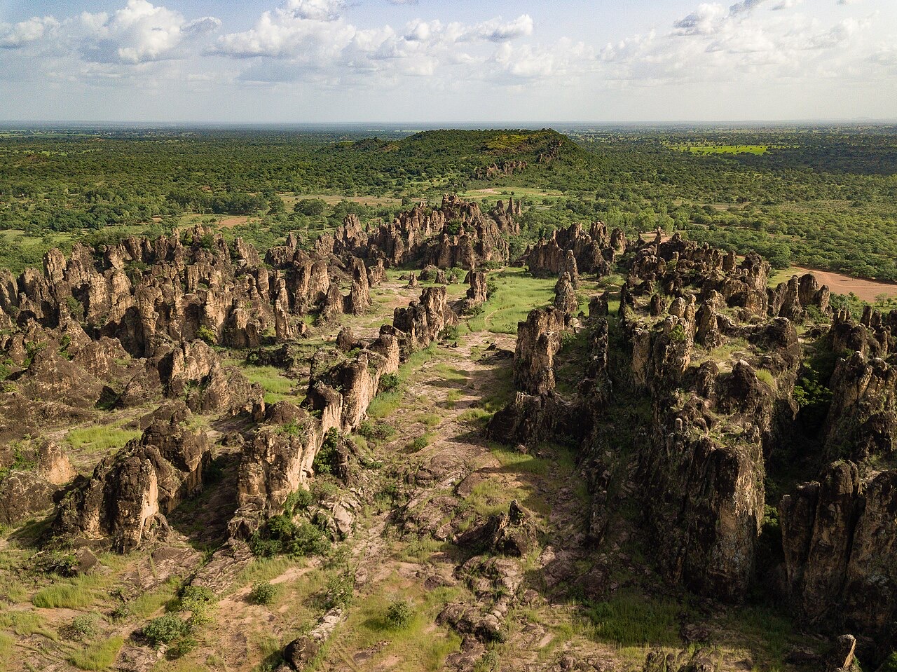
The Sindou Peaks and the Cascades near Banfora introduce the sandstone landscapes of the southwest. Ouagadougou’s Moro-Naba palace is associated with the traditional leadership of the Mossi kingdom of Ouagadougou. Map pins mark approximate learning locations, not entrances or indications of present access.
People & Society of Burkina Faso
Many communities, faiths and connections across borders.
- Are all Burkinabè people Mossi?
- No. The country includes many different communities.
- Which religions are practised?
- Islam, Christianity and traditional beliefs, among others.
- How are Burkina Faso and Côte d’Ivoire connected?
- Through longstanding family, migration, work and trading ties.
More about Burkina Faso: people & society
Burkina Faso’s people include Mossi, Fulani, Bobo, Lobi, Gourmantché, Bissa and many other communities. Identities and livelihoods are varied and change over time. Islam, Christianity and traditional beliefs are practised, sometimes within the same extended families.
Families, markets, schools and migration connect towns and rural areas. Burkinabè communities also have longstanding ties with neighbouring Côte d’Ivoire and other countries. Armed conflict has displaced many people and affected access to schools and health care, while communities continue to maintain social and cultural life.