Facts about Central African Republic
Explore the Central African Republic from Bangui on the Ubangi to the western highlands, northern savannas and Dzanga-Sangha forests. Twelve cities and towns, ten heritage and landscape locations and ten illustrated topics connect geography with history, languages and everyday life.
- Capital
- Bangui
- Area
- About 623,000 km²
- Official languages
- Sango and French
- Currency
- Central African CFA franc (XAF)
- Independence
- 13 August 1960
- Highest summit
- Mount Ngaoui
Central African Republic · 0 of 20 rounds passed
Two timed rounds per topic, 20 seconds a question
Bangui and neighbouring Bimbo introduce the southwestern river corridor. Berbérati and Bouar orient the western forests and uplands, while Bossangoa and Kaga-Bandoro connect the interior with northern drainage systems. Bambari and Bria mark central and eastern trading centres.
Bangassou lies on the Mbomou near the DRC, Obo in the far east, and Ndélé and Birao in the northern borderlands. The heritage map ranges from Bangui’s cathedral and Bouar’s megalithic landscape to Boali Falls, Dzanga Bai and northern savanna parks. Pins are learning locations rather than travel routes.
Geography of the Central African Republic
Two drainage basins connect the central plateau with the Congo River and Lake Chad.
- Which six countries border the Central African Republic?
- Cameroon, Chad, Sudan, South Sudan, the DRC and the Republic of the Congo.
- Which river runs beside Bangui?
- The Ubangi, a tributary of the Congo River.
- Where does water from the northern drainage basin go?
- Through the Chari river system toward Lake Chad, rather than into the Congo Basin.
More about Central African Republic: geography
The Central African Republic is a landlocked country of about 623,000 square kilometres. It borders Cameroon, Chad, Sudan, South Sudan, the Democratic Republic of the Congo and the Republic of the Congo. Bangui, the capital, stands beside the Ubangi, also written Oubangui, facing the DRC. Western uplands around Bouar rise above a broad interior plateau; Mount Ngaoui, on the Cameroonian border, is the highest summit. Forest is especially important in the southwest, while savanna and woodland extend across much of the interior and north.
A watershed divides two great drainage systems. The Ubangi and Sangha carry water toward the Congo River; the Ouham and other northern rivers contribute to the Chari system and Lake Chad. Rainfall generally decreases toward the north, and wet and dry seasons shape roads, farming and river transport. The map’s twelve settlements introduce these regions: Berbérati and Bouar in the west, Bossangoa and Kaga-Bandoro farther inland, Bambari and Bria in the centre and east, and Bangassou, Obo, Ndélé and Birao toward the eastern and northern borderlands.
History of the Central African Republic
Ubangi-Shari, independence in 1960 and the distinction between Bokassa’s empire and coronation.
- When did the country become independent?
- On 13 August 1960, from France.
- What was Ubangi-Shari?
- The French colonial territory from which the modern Central African Republic emerged.
- Did Bokassa proclaim an empire and hold his coronation in the same year?
- No. The empire was proclaimed in 1976; the coronation took place in 1977.
More about Central African Republic: history
Long before the present borders, communities traded, farmed and developed political networks across the Ubangi and Chari basins. Northern states such as Dar al-Kuti linked these lands with wider trade networks, including the violent trade in enslaved people. French conquest produced the colony of Ubangi-Shari, later part of French Equatorial Africa. Concessionary companies and forced labour brought severe exploitation; the Kongo-Wara rebellion of 1928–1931 challenged colonial rule in the west and neighbouring territories.
Barthélemy Boganda, a former Catholic priest and political leader, helped establish the autonomous republic in 1958 but died in a plane crash in 1959. Independence from France followed on 13 August 1960, with David Dacko as president. Jean-Bédel Bokassa seized power in 1966, proclaimed the Central African Empire in 1976 and held his coronation in 1977. The republic was restored after his removal in 1979. Later coups and armed conflict, including the Séléka takeover in 2013 and violence involving anti-balaka groups, caused profound civilian suffering and displacement. These movements should not be treated as representing entire religious communities.
Sango, French and community languages
Sango links communities; French and many community languages also shape public and private life.
- Which languages are official?
- Sango and French.
- What role does Sango play?
- It is widely used for communication between communities as well as in everyday family and public life.
- Which language does the linked Worldly course teach?
- General French. Worldly does not yet offer a dedicated Sango course.
More about Central African Republic: language
Sango and French are the official languages of the Central African Republic. Sango developed as a language of wider communication along the Ubangi and is now spoken in homes, markets, broadcasting and public life. It draws much of its vocabulary from Ngbandi, an Ubangian language and has also borrowed from French. Descriptions of its development differ, but it is neither a dialect of French nor a language that belongs only to one community. Tone helps distinguish words and meanings.
French has important roles in administration, written documents and formal education, although access and proficiency vary. Gbaya, Banda, Ngbaka, Zande and many other languages form part of the country’s linguistic life. Such names can encompass several related varieties; language counts depend on classification. Multilingual speakers may choose different languages with family, neighbours and officials. Worldly’s linked lessons introduce general French. They are not Sango lessons, and learning French alone does not describe how people communicate everywhere in the country.
Culture of the Central African Republic
Aka polyphonic singing, oral traditions and urban creativity are living, changing practices.
- What does polyphonic singing mean here?
- Several distinct vocal lines sound together, with interlocking patterns and improvisation.
- Does the Aka tradition represent every Central African community?
- No. It belongs to particular communities within a much wider range of cultural practices.
- How is this musical knowledge passed on?
- Through participation, observation and practice across generations.
More about Central African Republic: culture
Aka communities in the southwestern forests maintain a rich polyphonic singing tradition: several voices combine interlocking melodies, rhythm and improvisation. UNESCO’s intangible heritage inscription recognises the transmission of this knowledge through participation, including at ceremonies connected with hunting, new encampments and funerals. The music is a living social practice, not simply a performance for outsiders. The historical wording of the UNESCO title uses a broad label for forest peoples; naming the Aka communities themselves is more precise.
Other Central African communities have their own music, dances, storytelling and material arts. Instruments include drums and lamellophones, often called sanza; urban musicians also draw on regional popular styles. The Tombindo dance-group photograph illustrates one performance rather than a single national costume. Christian churches, Muslim communities and indigenous religious practices contribute to public and family life, with considerable local variation. Traditions change through migration, education, radio and the creative choices of younger generations.
Economy of the Central African Republic
Farming, forest livelihoods and mineral resources depend on transport, security and access to services.
- What currency is used?
- The Central African CFA franc, XAF, issued by BEAC.
- Why do transport corridors matter?
- A landlocked country depends on connections to ports and regional markets; disruption raises costs.
- Does mineral wealth mean most households are prosperous?
- No. Security, institutions, infrastructure and access to services shape who benefits.
More about Central African Republic: economy
Farming supports many Central African households. Cassava, maize, groundnuts and other crops feed local markets, while cotton and coffee have histories as cash crops. Fishing, livestock keeping, forest products and small businesses add to livelihoods. Timber, diamonds and gold are important resources, but export earnings do not automatically translate into widely shared prosperity. Insecurity, weak infrastructure and limited access to electricity, health care, finance and education constrain economic opportunities.
Being landlocked makes transport links crucial. Road corridors through Cameroon connect the country with the port of Douala; river transport links Bangui with the wider Congo Basin, subject to seasonal water conditions. Disruption and high fuel costs raise the price of everyday goods. The currency is the Central African CFA franc, code XAF, issued by BEAC for the six-country CEMAC monetary area. It is distinct from the West African CFA franc, XOF. The World Bank’s country overview emphasises the gap between substantial natural wealth and human development outcomes.
Politics of the Central African Republic
The 2023 constitution and the December 2025 elections belong in a changing institutional history.
- What changed under the 2023 constitution?
- Presidential term limits were removed and the presidential term was extended to seven years.
- What does the World Bank report about the December 2025 elections?
- That Faustin-Archange Touadéra was re-elected president.
- What is MINUSCA?
- The United Nations peacekeeping mission in the Central African Republic, established in 2014.
More about Central African Republic: politics
The Central African Republic is a republic with a president, a prime minister and representative institutions. A new constitution adopted in 2023 removed presidential term limits and extended the presidential term from five to seven years. These changes were politically contested. The World Bank’s 2026 country overview records that the December 2025 general elections returned Faustin-Archange Touadéra to the presidency. Institutional descriptions need dates: a constitution, an election result and effective public authority are related but different things.
Armed conflict has affected the state’s reach and people’s security beyond Bangui. The 2019 Political Agreement for Peace and Reconciliation sought to reduce violence between the government and armed groups; implementation, disarmament and local reconciliation remain important. MINUSCA is the United Nations peacekeeping mission established in 2014, with protection of civilians central to its mandate. Security partnerships and conditions change over time. A learning map does not show current control lines, and it cannot establish whether a road or destination is safe.
Nature & Wildlife of the Central African Republic
Forest clearings, savanna and woodland support different habitats and conservation challenges.
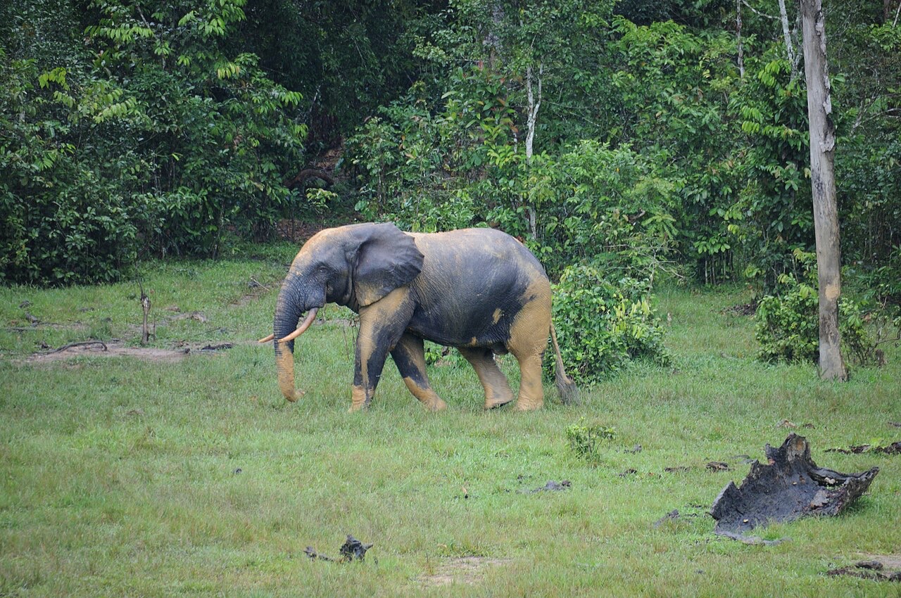
- Why do elephants gather at Dzanga Bai?
- The natural forest clearing offers mineral-rich water and soil.
- Which three countries share Sangha Trinational?
- The Central African Republic, Cameroon and the Republic of the Congo.
- Is Manovo-Gounda St Floris mainly equatorial rainforest?
- No. It is associated with northern savanna, woodland and floodplain habitats.
More about Central African Republic: nature & wildlife
The southwestern forests belong to the Congo Basin. At Dzanga Bai, a mineral-rich clearing, forest elephants gather in a place where researchers can observe their behaviour. Western lowland gorillas, chimpanzees and forest antelopes also occur in the wider landscape. Forest elephants are a distinct species from savanna elephants. The Dzanga-Sangha protected-area complex includes a special reserve and Dzanga-Ndoki National Park; these names do not all describe the same boundary.
Dzanga-Ndoki forms part of the Sangha Trinational World Heritage property, shared with Cameroon and the Republic of the Congo and inscribed in 2012. Farther north, Manovo-Gounda St Floris protects savanna, woodland and floodplain habitats; UNESCO inscribed it in 1988 and placed it on the Danger List in 1997. Poaching, insecurity and habitat pressures threaten conservation. Bamingui-Bangoran and the eastern Chinko landscape add other habitat mosaics. Conservation involves local residents’ livelihoods and rights as well as wildlife protection; historical species lists do not establish present population sizes.
Food & Cuisine of the Central African Republic
Cassava, leafy sauces, groundnuts and river fish connect meals with local farming and waterways.
- What is gozo?
- A cooked dough commonly made from cassava flour.
- How are groundnuts used in meals?
- They can be ground into paste to thicken sauces and stews.
- Where do many local fish dishes get their main ingredient?
- From the Ubangi and other rivers, rather than a national coastline.
More about Central African Republic: food & cuisine
Cassava is an important staple, including as a cooked flour dough often called gozo. Cassava leaves also appear in sauces, sometimes called ngunza or ngoundja, with recipes and spellings varying between communities. Cassava roots and leaves require appropriate processing and cooking. Groundnuts thicken many sauces; maize, rice, plantains and other ingredients broaden the range of meals according to region, season and household resources.
The Ubangi and other rivers supply fish, which may be fresh, smoked or dried. Leaf-wrapped preparations often called maboké belong to a wider Central African culinary world, with local variations in fish, vegetables and seasoning. Markets and roadside vendors sell bread, cooked foods and ingredients; the photograph here shows a bread trader in Bangui rather than a plate of cassava. Access to food is shaped by harvests, transport costs and insecurity. A national food list cannot describe every family’s diet or imply that all households can obtain the same ingredients.
Landmarks of the Central African Republic
Boali Falls, Bangui’s urban heritage and Bouar’s standing stones tell different kinds of stories.
- Which river forms Boali Falls?
- The Mbali River, northwest of Bangui.
- Are Bouar’s megaliths an inscribed World Heritage property?
- No. The site appears on the UNESCO Tentative List, which is a different status.
- What does the guide’s pin for a national park show?
- A representative learning location, not a park boundary or visitor entrance.
More about Central African Republic: landmarks
Boali Falls lies on the Mbali River northwest of Bangui, near hydroelectric installations. The water flow varies, so one photograph cannot show every season. In Bangui, Notre-Dame Cathedral is a red-brick place of Catholic worship, while the Boganda Museum is associated with the country’s cultural collections and history. These urban sites remain part of a living city rather than an open-air collection of monuments. Current opening arrangements must be checked separately.
The western highlands around Bouar contain megalithic sites often known as tazunu. The Bouar megalithic landscape is on the UNESCO Tentative List; this is distinct from inscription on the World Heritage List. The country’s inscribed properties are natural ones: Manovo-Gounda St Floris and its part of Sangha Trinational. Kembé’s waterfalls on the Kotto add another river landscape in the southeast. The ten map locations combine specific buildings with broad archaeological and protected landscapes; approximate landscape pins are not entrances, surveyed boundaries or recommended travel routes.
People & Society of the Central African Republic
Community life, multilingual identities and creative work continue amid displacement and recovery.
- Does a community name tell you everyone’s livelihood?
- No. People have diverse occupations, languages and individual identities.
- How has displacement affected daily life?
- It has disrupted homes, schools, livelihoods and family networks, within the country and across borders.
- Who are two Central African literary voices?
- Étienne Goyémidé and Adrienne Yabouza.
More about Central African Republic: people & society
Central African society includes Gbaya, Banda, Mandjia, Sara, Mboum, Ngbaka, Zande and many other communities. Aka communities have deep connections with southwestern forests, while Mbororo communities are associated with cattle pastoralism. These descriptions do not determine every person’s occupation, language or identity. Families move between towns and rural areas, combine livelihoods and maintain links across present national borders. Bangui is the main urban centre, but the capital does not represent all regional experiences.
Conflict has displaced many people within the country and into neighbouring states, interrupting schooling, farming and family networks. Return, rebuilding and access to services are uneven; current humanitarian figures need a date and source. Central Africans also shape the country through teaching, trade, sport and the arts. Writer Étienne Goyémidé and novelist Adrienne Yabouza are examples of literary voices whose work reaches beyond the country. The city-traffic photograph illustrates one moment in Bangui, not a picture of every Central African’s daily life.