Facts about Venezuela
Venezuela brings Caribbean islands, western Andean peaks, the Orinoco plains and the tepuis of the Guiana Highlands into one country. Explore its regions, cities and waters, then discover the histories, languages, food and communities behind those places.
- Capital
- Caracas
- Currency
- Venezuelan bolívar (VES)
- National official language
- Spanish
- Highest mountain
- Pico Bolívar
- Main river basin
- Orinoco
- Northern coast
- Caribbean Sea
Venezuela · 0 of 20 rounds passed
Two timed rounds per topic, 20 seconds a question
Caracas sits in a coastal mountain valley, Maracaibo beside the strait connecting its lake with the sea, and Valencia near the country’s central industrial corridor. Barquisimeto anchors the west-central interior, while Mérida and San Cristóbal lie in the Andes. Eastward, Cumaná faces the Caribbean and Ciudad Bolívar stands on the Orinoco. Ciudad Guayana grew around the meeting of the Caroní and Orinoco rivers.
The Llanos spread south of the northern mountains, with San Fernando de Apure beside its namesake river. Puerto Ayacucho connects with the upper Orinoco, Tucupita with the delta and Santa Elena de Uairén with the Gran Sabana. Three maps cover 25 administered regions, 24 selected cities and ten waters. Spanish lessons teach everyday phrases, while the reading also recognises Indigenous languages. A scope note explains the distinction between the mapped territory and Venezuela’s claim to Essequibo.
Geography of Venezuela
Caribbean shores, western Andes, the Llanos and the ancient Guiana Highlands meet around the Orinoco basin.
- Which countries border Venezuela?
- Colombia borders Venezuela to the west, Brazil to the south and Guyana to the east. The Caribbean Sea lies to the north, and the Orinoco delta reaches the Atlantic.
- What are the Llanos?
- The Llanos are tropical plains in Venezuela and Colombia, largely within the Orinoco basin. Seasonal rain transforms grasslands and river margins into extensive wetlands.
- Are tepuis part of the Andes?
- No. Tepuis are flat-topped mountains in the ancient Guiana Highlands, especially in southeastern Venezuela. The Andes lie in the country’s west.
More about Venezuela: geography
Venezuela occupies the northern edge of South America, bordering Colombia, Brazil and Guyana. The Caribbean lies to the north, while the Orinoco delta opens towards the Atlantic in the east. The Andes reach into the west around Mérida, with Pico Bolívar the country’s highest mountain. Caracas sits in a mountain valley close to the coast, separated from the sea by the coastal range.
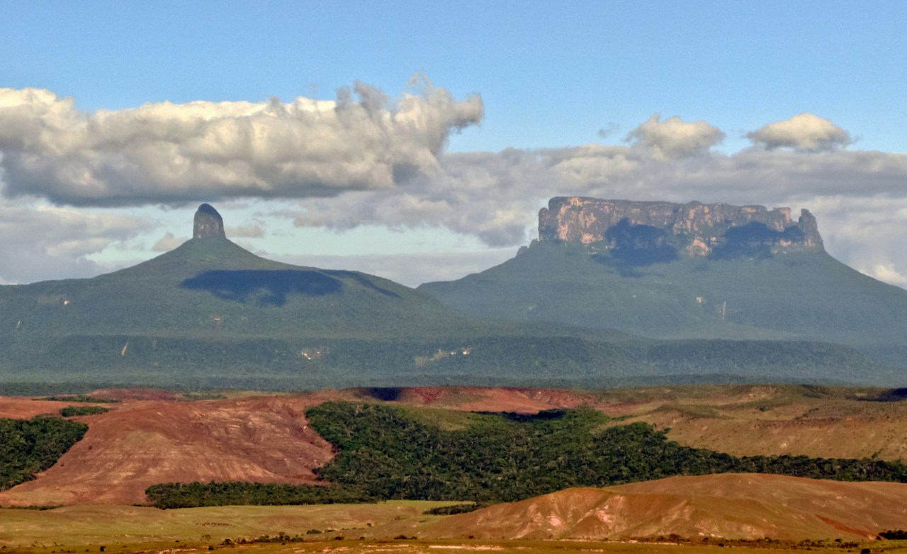
The Llanos are seasonally flooded plains shared with Colombia. South of the Orinoco, the Guiana Highlands include flat-topped mountains called tepuis, as well as forest and savanna. Lake Maracaibo in the northwest connects with the Gulf of Venezuela; Lake Valencia lies inland between Valencia and Maracay. Elevation and rainfall produce major differences between cool Andean towns, dry Caribbean shores and humid southern forests.
History of Venezuela
Indigenous societies, the independence struggle and the transformation of a farming economy into an oil-producing country.
- When did Venezuela declare independence?
- Venezuela declared independence from Spain on 5 July 1811. Fighting continued afterwards; the Battle of Carabobo in 1821 was a decisive independence victory.
- Who was Simón Bolívar?
- Bolívar was a Caracas-born leader in the independence struggles of northern South America. His campaigns helped establish independent republics beyond Venezuela as well.
- Was Venezuela part of Gran Colombia?
- Yes. Venezuela formed part of the republic commonly called Gran Colombia, alongside territories that became Colombia, Panama and Ecuador. Venezuela separated in 1830.
More about Venezuela: history
Indigenous peoples lived across the coast, mountains, plains and forests long before Europeans arrived. Spanish colonisation brought new settlements, forced labour and the enslavement of Africans. Venezuela declared independence on 5 July 1811, but the struggle continued for years. Simón Bolívar was a leading figure in that struggle, and the Battle of Carabobo in 1821 was a decisive victory for independence forces.
Venezuela belonged to the republic commonly called Gran Colombia before separating in 1830. Regional strongmen and civil wars shaped much of the nineteenth century. Oil production transformed the economy and cities during the twentieth century, especially around Lake Maracaibo. The dictatorship of Marcos Pérez Jiménez ended in 1958, followed by an elected civilian political system. Hugo Chávez’s election in 1998 and the 1999 constitution began another major political transition.
Languages of Venezuela
Spanish connects public life across the country, alongside Indigenous languages with their own communities and constitutional recognition.
- What language is spoken in Venezuela?
- Spanish is the official national language and is widely spoken. Indigenous languages including Wayuunaiki, Warao and Pemón languages also remain in use.
- Does Venezuela recognise Indigenous languages?
- Yes. Article 9 of the constitution makes Indigenous languages official for Indigenous peoples and says they must be respected throughout the republic.
- What does chévere mean?
- Chévere is an informal word often meaning good, great or enjoyable. It is common in Venezuela and is also used in several other Latin American countries.
More about Venezuela: language
Spanish is the official language nationwide. Article 9 of the constitution also recognises Indigenous languages as official for Indigenous peoples and calls for their respect throughout the country. Wayuunaiki is spoken by Wayuu communities on both sides of the Colombian border; Warao is associated with the Orinoco delta, and Pemón languages with southeastern highland communities. These are distinct languages, not varieties of Spanish.
Venezuelan Spanish varies by region. Caribbean-influenced coastal speech differs from Andean varieties, and familiar forms of address include tú, usted and regional uses of vos. Pana can mean a friend, while chévere often means good or enjoyable. The Spanish lessons here teach useful everyday phrases; local vocabulary and pronunciation add another layer when listening to Venezuelan speakers.
Culture of Venezuela
Joropo on the plains, gaita in Zulia, Corpus Christi traditions and a deep enthusiasm for baseball.
- What is joropo?
- Joropo is a music and dance tradition with several regional forms. The llanero tradition is shared across Venezuela and Colombia and commonly features harp, cuatro and maracas.
- What is a Venezuelan cuatro?
- The cuatro is a small four-stringed instrument used in many Venezuelan musical traditions. It provides rhythmic and harmonic accompaniment and can also be played as a solo instrument.
- What are the Dancing Devils of Corpus Christi?
- They are community brotherhoods whose masked dances form part of Corpus Christi celebrations. UNESCO recognises the Venezuelan tradition as intangible cultural heritage.
More about Venezuela: culture
Joropo combines music, singing and dance, with traditions shared across the Venezuelan and Colombian Llanos. Harp, cuatro and maracas are characteristic instruments in llanero ensembles. The cuatro is a small four-stringed instrument closely associated with Venezuelan music. Gaita zuliana is rooted in Zulia, while Afro-Venezuelan drumming traditions have strong coastal connections. Regional traditions give the country a wider musical identity than any single style can represent.
The Dancing Devils of Corpus Christi combine Catholic celebration with community practices shaped by African and Indigenous heritage. UNESCO recognises the tradition as intangible cultural heritage. El Sistema became internationally known for its orchestral music education, while writers such as Rómulo Gallegos explored the country’s landscapes and social tensions. Baseball is especially popular, alongside football and other sports. Venezuelan communities abroad continue to reshape these cultural connections.
Economy of Venezuela
Oil shaped export earnings and urban growth, while farming, services and the Caroní’s hydropower connect other regions.
- Where is Venezuela’s Orinoco Oil Belt?
- The Orinoco Belt lies north of the Orinoco River in eastern Venezuela. It contains extensive extra-heavy crude resources that need specialised production and processing.
- What is PDVSA?
- Petróleos de Venezuela, usually called PDVSA, is Venezuela’s state oil company. Oil exports have played a major role in national revenue.
- Why is the Caroní River important for electricity?
- The Caroní supports major hydroelectric dams, including Guri. Its power helped support industry around Ciudad Guayana as well as the national electricity system.
More about Venezuela: economy
Oil has long dominated Venezuela’s export earnings. Production developed around Lake Maracaibo and in eastern fields, while the Orinoco Belt contains large extra-heavy crude resources. Large reserves do not automatically mean high output: extraction, upgrading, maintenance and investment all matter. PDVSA is the state oil company. Changes in oil prices and production have affected public finances and households far beyond the oil fields.
Farming produces foods including maize, rice, coffee and cacao, while cattle raising is associated with the Llanos. Industry around Ciudad Guayana developed alongside iron ore and hydropower from the Caroní River, including the Guri reservoir. Economic contraction, inflation, policy decisions, deteriorating infrastructure and international sanctions have affected the economy. Services, small businesses and remittances also support livelihoods. Exchange rates and prices change too quickly to serve as permanent guide facts.
Politics and institutions of Venezuela
The constitutional framework, contested political institutions and a territorial dispute that requires care when reading maps.
- Does Venezuela have a two-chamber national parliament?
- No. The constitutional national legislature is the unicameral National Assembly. The constitution sets out executive, legislative, judicial, citizen and electoral branches of national public power.
- Are Caracas and the Capital District identical?
- No. The Capital District contains Libertador municipality, but the wider Caracas urban area also extends into Miranda. A city and an administrative district need not cover the same area.
- Why do maps show the Essequibo region differently?
- Venezuela claims the region, while Guyana administers it. The boundary dispute is before the International Court of Justice. This guide’s Venezuelan regional map follows administered territory and does not turn the claim into a state answer.
More about Venezuela: politics
The 1999 constitution, amended in 2009, describes Venezuela as a federal republic with an elected presidency and a unicameral National Assembly. Its national public power has executive, legislative, judicial, citizen and electoral branches. Describing that legal framework does not establish that institutions operate independently in practice. Political competition, civil liberties and the legitimacy of elections have been central issues in Venezuela’s recent history.
The maps here show 23 states, the Capital District and Federal Dependencies in territory administered by Venezuela. La Guaira is the state formerly called Vargas. Caracas extends beyond the small Capital District into neighbouring Miranda. Venezuela claims the Essequibo region administered by Guyana; that disputed territory is not presented here as an administered Venezuelan state. The boundary case is before the International Court of Justice. Maps of these places should distinguish administration from territorial claims.
Nature and wildlife of Venezuela
Tepui summits, Llanos wetlands, cloud forests and Caribbean reefs support very different ecosystems.
- Why are tepuis important for biodiversity?
- Their isolated summits and unusual conditions support specialised plants and animals. Some species have very restricted ranges, making habitat protection especially important.
- Which animals live in the Llanos?
- The plains and wetlands support capybaras, caimans, herons, ibises and many other species. Wildlife distributions change with habitat and seasonal flooding.
- Does Venezuela have coral reefs?
- Yes. Caribbean marine areas, including Los Roques, contain coral habitats alongside seagrass and mangroves. These ecosystems differ greatly from the country’s inland forests and plains.
More about Venezuela: nature & wildlife
Canaima National Park protects a landscape of tepuis, savannas and forest in southeastern Venezuela. Isolated summit environments support distinctive plants, including carnivorous species. The Guiana Highlands are geologically separate from the Andes. In the west, high Andean páramo and cloud forest have their own specialised wildlife and vegetation, while the southern forests connect with wider Amazonian ecosystems.
The Llanos support capybaras, caimans and large numbers of wetland birds. River systems provide habitat for freshwater dolphins and threatened Orinoco crocodiles. Mangroves, seagrass and coral habitats occur along Caribbean shores and islands, including Los Roques. Mining, mercury pollution, habitat loss and wildlife exploitation place pressure on ecosystems and local communities. Protection depends on what happens in river basins as well as inside park boundaries.
Food of Venezuela
Arepas, pabellón criollo, Christmas hallacas and coastal fish connect meals with local ingredients and family traditions.
- Are arepas only Venezuelan?
- No. Arepas are central to both Venezuelan and Colombian food traditions. Ingredients, shapes, fillings and ways of serving them vary within each country.
- What is pabellón criollo?
- Pabellón criollo is a dish of shredded beef, black beans and rice. Fried ripe plantain is a common accompaniment.
- What are hallacas?
- Hallacas are parcels of maize dough with a seasoned filling, wrapped in leaves and cooked. They are especially associated with Christmas and shared family preparation.
More about Venezuela: food & cuisine
Arepas are maize cakes eaten with many fillings and accompaniments. They belong to food traditions in both Venezuela and Colombia, with regional differences in preparation. Venezuelan areperas commonly split and fill them; reina pepiada combines chicken and avocado. Pabellón criollo brings together shredded beef, black beans and rice, often with fried ripe plantain. Cachapas are tender sweetcorn pancakes frequently served with fresh cheese.
Hallacas are made with maize dough and a seasoned filling, wrapped in plantain or banana leaves and cooked. Families often prepare them together for Christmas, with recipes that vary by region and household. Coastal cooking includes fish and seafood, while Andean dishes include soups such as pisca andina. Cacao and coffee have long histories in Venezuelan agriculture. Contemporary restaurants and migrant kitchens carry these traditions into new settings.
Landmarks of Venezuela
Angel Falls, Canaima’s tepuis, Coro’s earthen architecture and the modern university campus in Caracas.
- Where is Angel Falls?
- Angel Falls descends from Auyán-tepui in Canaima National Park, in southeastern Venezuela. It is separate from the Andean mountains around Mérida.
- Why is the Ciudad Universitaria de Caracas UNESCO-listed?
- The university campus is an important work of modern architecture and urban design by Carlos Raúl Villanueva, integrating buildings, open spaces and visual art.
- What makes Coro and La Vela distinctive?
- Their historic buildings combine local and colonial traditions, including earthen construction. UNESCO recognises the town and port together as a World Heritage property.
More about Venezuela: landmarks
Angel Falls drops from Auyán-tepui in Canaima National Park and is widely described as the world’s highest waterfall. Water flow changes with the seasons. Canaima’s landscape also includes other tepuis and waterfalls; it is a living Indigenous homeland as well as a protected landscape. Mount Roraima stands at the meeting of Venezuela, Brazil and Guyana. Los Roques, farther north in the Caribbean, has a very different landscape of low islands and marine habitats.
Coro and its port, La Vela, are recognised by UNESCO for a historic urban landscape combining local and colonial building traditions, including earthen construction. The Ciudad Universitaria de Caracas, designed by Carlos Raúl Villanueva, brings modern architecture together with major works of art. In the west, Mérida connects with Andean scenery. These places illustrate different parts of Venezuela’s natural and built heritage; their significance is broader than a list of visitor attractions.
People and society of Venezuela
Urban communities, Indigenous homelands, African and European heritage and a diaspora with connections across the world.
- Where do many Venezuelans live within the country?
- Population is concentrated in northern urban areas. Major cities include Caracas, Maracaibo, Valencia, Maracay and Barquisimeto, although communities live across all regions.
- Are Indigenous communities still present in Venezuela?
- Yes. Wayuu, Warao, Pemón, Yanomami and other peoples maintain distinct communities, languages and cultural traditions. They are part of contemporary Venezuela.
- Is the Venezuelan diaspora concentrated in one country?
- No. Large Venezuelan communities live across Latin America and the Caribbean, as well as in North America, Europe and elsewhere. Their legal status and experiences vary.
More about Venezuela: people & society
Venezuelan society has been shaped by Indigenous peoples, African ancestry, Spanish colonisation and later migration from Europe, the Caribbean and elsewhere. Many people live in northern cities, including Caracas, Maracaibo, Valencia, Maracay and Barquisimeto. Regional identities differ between the Andes, Zulia, the Llanos, the east and the Guiana Highlands. These identities overlap with family, neighbourhood and community ties rather than forming fixed categories.
Indigenous peoples include Wayuu, Warao, Pemón and Yanomami communities, among many others, with distinct languages and territories. Migration from Venezuela has created large communities across Latin America and farther afield. UNHCR describes a displacement situation involving refugees and migrants with varied legal circumstances. Families often maintain relationships across borders through communication, remittances, food and music. Changing migration totals need a dated source rather than a permanent headline number.