Facts about Guyana
Guyana connects South America’s Atlantic coast with the forests of the Guiana Shield and the Rupununi savannahs. Discover its ten regions, river journeys, Indigenous heritage and Caribbean connections through three maps and ten illustrated topics.
- Capital
- Georgetown
- Currency
- Guyanese dollar (GYD)
- Official language
- English
- Administrative regions
- 10
- Largest river system
- Essequibo
- Coast
- Atlantic Ocean
Guyana · 0 of 20 rounds passed
Two timed rounds per topic, 20 seconds a question
Georgetown stands at the Demerara’s mouth, opposite Vreed-en-Hoop. Parika connects with the Essequibo islands and Anna Regina with the Essequibo coast. New Amsterdam faces the Berbice River, while Rose Hall and Corriverton lie farther east. Mabaruma and Port Kaituma connect the northwest’s river communities. The coast’s sea defences and drainage canals are as much a part of its geography as the shoreline.
Inland, Linden and Kwakwani connect with mining and river transport, Bartica stands near the Essequibo–Mazaruni confluence, and Mahdia serves the Potaro interior. Farther south, Annai and Lethem lie in the Rupununi. The water map follows eight river mainstems and the wider Atlantic, including Venezuelan and Brazilian reaches. English is official, while Creolese and Indigenous languages are part of daily life; the guide explains them without offering an unrelated language course.
Geography of Guyana
A low Atlantic coast, forested Guiana Shield and Rupununi grasslands, connected by rivers.
- Which countries border Guyana?
- Guyana borders Venezuela to the west, Brazil to the south and southwest, and Suriname to the east. Its northern coast faces the Atlantic Ocean.
- Is Guyana on the Caribbean Sea?
- Guyana’s coast faces the Atlantic Ocean. Its close Caribbean connections reflect shared history, culture and institutions, including membership of the Caribbean Community, CARICOM.
- Where are the Rupununi savannahs?
- The Rupununi savannahs lie in southern Guyana, around the Kanuku Mountains and towards Brazil. Seasonal flooding connects grasslands, wetlands and neighbouring river systems.
More about Guyana: geography
Guyana lies on South America’s northeastern Atlantic coast between Venezuela, Brazil and Suriname. Georgetown stands at the Demerara River’s mouth. Much of the population and cultivated land occupies the narrow coastal plain, where sea defences, mangroves, drainage canals and sluices help manage water. Inland, forests cover much of the ancient Guiana Shield, with the Pakaraima Mountains in the west and Rupununi savannahs farther south. Mount Roraima stands at the meeting of Guyana, Venezuela and Brazil.
The Essequibo is the country’s largest river system. The Potaro, Mazaruni, Cuyuni and Rupununi connect with it, while the Demerara, Berbice and Corentyne reach the Atlantic separately. Near Lethem, the Takutu flows towards Brazil’s Branco and the Amazon basin. Ten administrative regions link these different environments. The map shows complete available river mainstems, including reaches beyond Guyana, and the Atlantic’s wider extent; waterways do not stop at national borders.
History of Guyana
Indigenous homelands, Dutch and British plantations, emancipation, indenture and independence in 1966.
- When did Guyana become independent?
- Guyana became independent from Britain on 26 May 1966. It became a republic on 23 February 1970, the anniversary celebrated through Republic Day and Mashramani.
- What was British Guiana?
- British Guiana was the colony formed in 1831 from Demerara, Essequibo and Berbice. The independent country adopted the name Guyana when British rule ended in 1966.
- Who was Cuffy?
- Cuffy was a leader of the 1763 Berbice rebellion against slavery and Dutch colonial rule. He is commemorated in Guyana as a national hero.
More about Guyana: history
Indigenous peoples inhabited the region long before European colonisation and remain part of contemporary Guyana. Dutch colonies developed around the Essequibo, Demerara and Berbice rivers, using enslaved African labour on plantations. The 1763 Berbice rebellion, associated with Cuffy, challenged slavery and colonial authority. Britain acquired the colonies in 1814 and united them as British Guiana in 1831. Emancipation began in 1834, followed by an apprenticeship system that ended in 1838.
Indentured workers arrived from India from 1838, alongside migration from Madeira, China and elsewhere. Their experiences shaped the coast’s communities and economy without erasing the violence of plantation rule. Guyana became independent on 26 May 1966 and a republic on 23 February 1970; these are separate milestones. Cheddi Jagan and Forbes Burnham were central political figures. Offshore oil discovery in 2015 and commercial production from 2019 mark a much later economic transition.
Languages of Guyana
Official English, everyday Guyanese Creole and distinct Indigenous languages with living communities.
- What is Guyana’s official language?
- English is Guyana’s official language. Guyanese Creole is widely spoken in everyday life, while Indigenous languages and other heritage languages remain important in different communities.
- Is Guyanese Creole the same as formal English?
- Guyanese Creole has its own grammatical patterns and conventions. Many speakers move between Creole and more formal English depending on their audience and circumstances.
- Are Indigenous languages still spoken in Guyana?
- Yes. Makushi, Wapishana, Patamona, Akawaio and other languages are spoken in Guyana. Their vitality varies, and communities undertake different teaching, documentation and revitalisation efforts.
More about Guyana: language
English is Guyana’s official language and is used in government, schooling and much published writing. Guyanese Creole, often called Creolese, is widely used in everyday conversation. It has an English vocabulary base and its own grammatical patterns, shaped by contact among communities. Speakers may shift between varieties according to setting. Describing Creole as simply incorrect English misses its structure, expressive range and importance in storytelling, comedy and ordinary social life.
Indigenous languages include Makushi, Wapishana, Patamona, Akawaio, Wai Wai, Lokono and Warao, among others. They belong to different language families and have different patterns of use and transmission. Indo-Guyanese heritage includes Bhojpuri-derived Hindustani traditions, although English and Creole are now widespread across communities. Language is not a reliable shortcut for a person’s ancestry or religion. This guide explains that diversity without inventing an English course or linking to an unrelated language.
Culture of Guyana
Mashramani, Phagwah, cricket, literature and music connect local traditions with the wider Caribbean.
- What does Mashramani celebrate?
- Mashramani accompanies Guyana’s Republic Day on 23 February. Costumes, music and street celebrations mark the country’s transition to republican status in 1970.
- What is Phagwah?
- Phagwah is the Guyanese name commonly used for Holi, the Hindu spring festival associated with colour. It is part of the country’s varied religious calendar.
- Which international cricket side includes Guyanese players?
- Guyanese players can represent the West Indies in international cricket. Domestic Guyanese teams also compete in regional competitions involving other Caribbean cricket territories.
More about Guyana: culture
Guyana’s cultural calendar brings together different histories and faiths. Mashramani accompanies Republic Day in February with costumes, music and public celebrations. Phagwah, the local name for Holi, and Diwali are important Hindu festivals; Eid, Christmas and emancipation commemorations also form part of public life. Amerindian Heritage Month in September highlights Indigenous communities and their living traditions. Participation and practice vary between families, settlements and regions.
Cricket links Guyana with the West Indies sporting tradition. Music includes calypso, soca, chutney and steelpan, alongside other local and international styles. Chutney has strong Indo-Caribbean connections; steelpan developed in Trinidad and Tobago. Writers such as Wilson Harris and E. R. Braithwaite carried Guyanese experiences into international literature. Braithwaite’s To Sir, with Love draws on teaching in London. Diaspora communities continue to reshape these traditions through performance, writing and family celebrations.
Economy of Guyana
Offshore oil joins gold, bauxite, rice, sugar, forestry and services in a rapidly changing economy.
- When did Guyana start producing offshore oil?
- Commercial production from the Liza field began in December 2019. The major Stabroek discovery had been announced in 2015, several years before production started.
- What does Guyana produce besides oil?
- Guyana produces gold, bauxite, rice, sugar, timber and fish, among other goods. Agriculture, mining, forestry and services have different importance across the coast and interior.
- What currency does Guyana use?
- Guyana uses the Guyanese dollar, with the international currency code GYD. It is separate from the East Caribbean dollar used by several island states.
More about Guyana: economy
Guyana’s economy has long depended on a mixture of coastal agriculture and interior resources. Rice and sugar are associated with the cultivated lowlands, while gold mining operates in forested river basins. Bauxite extraction helped shape Linden on the Demerara River. Forestry, fishing, trade and public services also support livelihoods. These activities have different regional effects, from the maintenance of coastal drainage to mining-related pressures on forests and waterways.
A major discovery in the offshore Stabroek Block was announced in 2015, and production from the Liza field began in December 2019. Petroleum has since transformed export earnings and government finances. National GDP growth does not describe every household’s circumstances: the distribution of benefits, skills, infrastructure and environmental protection remain central questions. The Natural Resource Fund receives petroleum revenues under a statutory framework. The currency remains the Guyanese dollar, abbreviated GYD; this guide avoids undated output and growth forecasts.
Government and international relations of Guyana
An executive presidency, a single-chamber parliament, ten regions and strong CARICOM connections.
- What type of government does Guyana have?
- Guyana is a republic with an executive president and a single-chamber National Assembly. The president heads both the state and government under the constitutional framework.
- Why is CARICOM important to Guyana?
- Guyana is a founding member of the Caribbean Community, whose secretariat is based in the Georgetown area. Membership reflects longstanding regional political, cultural and economic connections.
- What does the Guyana–Venezuela map show?
- The guide maps Guyana’s administered regions, including Essequibo. Venezuela contests the boundary, and the ICJ case concerns the 1899 award; the map does not resolve sovereignty.
More about Guyana: politics
Guyana is officially the Co-operative Republic of Guyana. Its constitution provides for an executive president and a single-chamber National Assembly. General elections use proportional representation, while regional and local bodies have their own responsibilities. The president is both head of state and head of government, with a prime minister serving in the executive. Constitutional rules and political practice should be distinguished; Guyana’s elections, institutions and community relationships have generated sustained public debate.
Guyana is a founding CARICOM member, and the community’s secretariat is based in the Georgetown area. It also belongs to the Commonwealth. Venezuela claims the Essequibo territory administered by Guyana; the dispute over the 1899 arbitral award is before the International Court of Justice. Jurisdictional decisions are distinct from a final decision on the merits. Suriname also disputes the New River Triangle in the southeast. The guide’s map is a learning reference and does not settle either claim.
Nature and wildlife of Guyana
Rainforest, savannah, rivers and mangroves support remarkable wildlife and community conservation.
- What is Iwokrama?
- Iwokrama is a forest research and conservation initiative in central Guyana. It works on sustainable forest management, biodiversity and partnerships with neighbouring Indigenous communities.
- Which turtles nest at Shell Beach?
- Shell Beach supports nesting leatherback, green, hawksbill and olive ridley sea turtles. Nesting activity varies by species and season along this northwestern Atlantic coast.
- Why are coastal mangroves important?
- Mangroves reduce wave energy, store carbon and provide habitat for juvenile fish and other wildlife. They complement engineered sea defences along Guyana’s vulnerable coastal plain.
More about Guyana: nature & wildlife
Guyana’s forests form part of the Guiana Shield, a region of ancient rocks and extensive tropical habitats. Jaguars, harpy eagles, giant river otters and many other species occur here, although sightings depend on habitat and season. Harpy eagles hunt forest animals including sloths and monkeys, while giant otters depend on healthy rivers. Iwokrama combines forest research, conservation and sustainable management; its work involves relationships with neighbouring Indigenous communities.
The Rupununi’s seasonal wetlands and savannahs differ from the interior’s closed forest. The Kanuku Mountains protect a further range of habitats. On the Atlantic coast, mangroves help buffer waves, store carbon and provide nursery habitat for fish. Shell Beach is important for nesting sea turtles, including leatherbacks, green turtles, hawksbills and olive ridleys. Mining, habitat disturbance and changing coastal conditions create conservation pressures. Protected areas are living landscapes connected with communities rather than empty wilderness.
Food of Guyana
Pepperpot, cassava, cook-up rice, roti and metemgee reflect different communities and shared tables.
- What is Guyanese pepperpot?
- Pepperpot is a meat dish flavoured with cassareep, made from cassava juice. It has Indigenous roots and is especially associated with Christmas meals in Guyana.
- What is metemgee?
- Metemgee is a Guyanese dish combining ground provisions, including root vegetables, with coconut milk. Ingredients and accompaniments vary between households and occasions.
- What is inside a pine tart?
- A Guyanese pine tart contains a sweet pineapple filling inside pastry. Its name refers to pineapple, and it is a familiar bakery and home-cooking treat.
More about Guyana: food & cuisine
Guyanese pepperpot is a slow-cooked meat dish coloured and flavoured with cassareep, a preparation made from cassava juice. It has Indigenous roots and is especially associated with Christmas, often served with bread. Cassava is important in Indigenous food traditions in other forms as well. Cook-up rice brings rice, peas or beans and other ingredients into one pot. Recipes vary with household preference, availability and occasion; there is no single version that represents every community.
Roti, dhal and curry reflect South Asian connections, while metemgee combines ground provisions such as root vegetables with coconut milk. Chinese Guyanese cooking also contributes to everyday meals. Pine tarts contain pineapple filling, and black cake uses dried fruit commonly soaked in alcoholic drinks. Demerara rum is associated with sugarcane molasses and a distinctive distilling heritage. Together these foods show exchange and adaptation across Indigenous, African, Asian and European histories rather than a fixed set of separate cuisines.
Landmarks of Guyana
Kaieteur Falls, Georgetown’s wooden cathedral, Stabroek Market and the forts of the Essequibo.
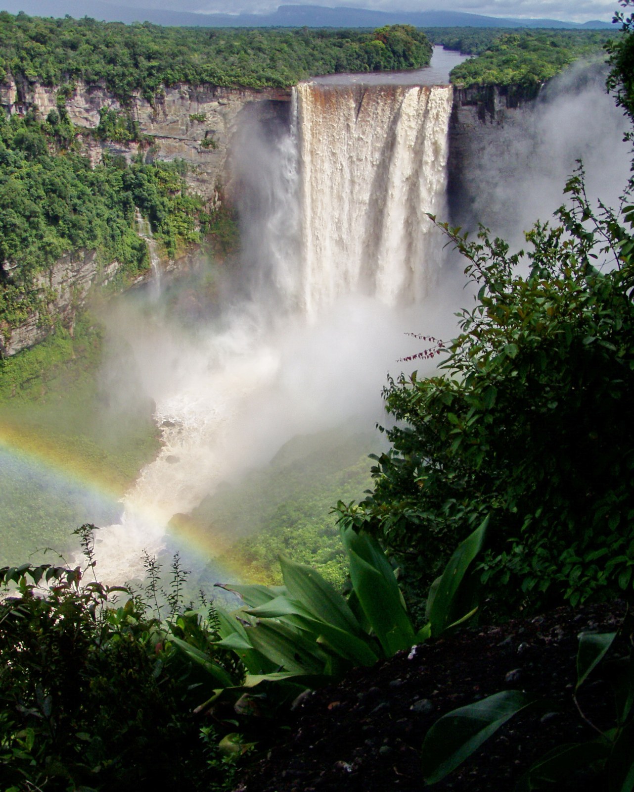
- Where is Kaieteur Falls?
- Kaieteur Falls lies on the Potaro River in Guyana’s forested interior, within Kaieteur National Park. Its main plunge is approximately 226 metres high.
- What is Georgetown’s best-known wooden landmark?
- Saint George’s Cathedral is a prominent wooden landmark in central Georgetown. Its architecture contrasts with the iron structure and clock tower of nearby Stabroek Market.
- What can be found on Fort Island?
- Fort Island in the Essequibo River contains Fort Zeelandia and the Court of Policy building. Both preserve evidence of Dutch colonial administration in the region.
More about Guyana: landmarks
Kaieteur Falls plunges about 226 metres in its main drop on the Potaro River, within Kaieteur National Park. Its setting is forested plateau country rather than the coastal plain. Farther south, the Rupununi and Kanuku Mountains offer a different landscape, with community tourism linking visitors to local knowledge and livelihoods. Mount Roraima is shared with Venezuela and Brazil; the usual walking approach to its summit is from Venezuela, so a map label is not an access route.
Georgetown’s Saint George’s Cathedral is a prominent wooden landmark, while Stabroek Market’s iron structure and clock tower overlook a busy trading area. The Walter Roth Museum of Anthropology presents Indigenous histories and material culture. On Fort Island in the Essequibo, Fort Zeelandia and the Court of Policy building recall Dutch colonial administration. New Amsterdam’s historic streets and riverfront tell another part of the coastal story. These sites connect architecture with the communities and labour that produced it.
People and society of Guyana
Coastal towns, Indigenous homelands and an international diaspora connect many different experiences.
- Where do most people in Guyana live?
- Most people live on the narrow Atlantic coastal plain, especially around Georgetown and other coastal settlements. The forested interior has a much lower population density.
- Which Indigenous peoples live in Guyana?
- Guyana’s Indigenous peoples include Makushi, Wapishana, Patamona, Akawaio, Wai Wai, Lokono and Warao communities, among others. Their languages, territories and experiences differ.
- Where is the Guyanese diaspora?
- Guyanese communities live in the United States, Canada, Britain and other countries. Many maintain connections with Guyana through family networks, cultural events, travel and remittances.
More about Guyana: people & society
Guyana’s people include communities with Indigenous, African, Indian, European, Chinese and mixed ancestry. These categories describe parts of history and identity, not fixed ways of living. Most residents live near the coast, with Georgetown the largest urban centre. Linden, New Amsterdam, Bartica and Lethem connect different regional economies. Indigenous communities across the interior and northwest maintain distinct relationships with land, language and local government; they are part of the country’s present as well as its past.
Christianity, Hinduism and Islam are important religious traditions, alongside other beliefs and practices. Large Guyanese communities live in the United States, Canada, Britain and elsewhere, maintaining family relationships, remittances and cultural exchange. Writers, musicians, sportspeople and public figures have contributed both locally and abroad. National or ethnic labels alone cannot describe those varied experiences. Population and migration totals change, so this guide emphasises settlement patterns and relationships rather than an undated headline number.