Facts about Suriname
Suriname connects an Atlantic plantation coast with the forests and rivers of the Guiana Shield. Explore ten districts, sixteen settlements and waterways that continue across borders, then discover the country’s languages, history, food and living traditions through ten illustrated topics.
- Capital
- Paramaribo
- Currency
- Surinamese dollar (SRD)
- Official language
- Dutch
- Administrative districts
- 10
- Independence
- 25 November 1975
- Coast
- Atlantic Ocean
Suriname · 0 of 20 rounds passed
Two timed rounds per topic, 20 seconds a question
Paramaribo’s wooden houses and Waterkant face the lower Suriname River. Lelydorp and Onverwacht connect the capital with Para’s savannah belt and Zanderij’s airport. Across the river, Meerzorg leads towards the Commewijne plantations and Fort Nieuw Amsterdam. To the west, Groningen, Totness, Wageningen and Nieuw Nickerie connect river landings, wetlands and cultivated coastal polders. Moengo and Albina lie eastwards towards French Guiana.
Inland, Brokopondo sits below the Afobaka dam, while Atjoni connects road travel with Upper Suriname river journeys. Drietabbetje lies on the Tapanahony and Apoera beside the Corantijn. Sipaliwini covers much of the forested interior. The water map follows nine full available river mainstems, including shared waterways beside Guyana and French Guiana, together with Brokopondo Reservoir and the wider Atlantic. Dutch lessons sit alongside reading about Sranan Tongo, Sarnami, Javanese, Maroon and Indigenous languages.
Geography of Suriname
An Atlantic coastal plain and a forested interior, connected by rivers flowing from the Guiana Shield.
- What borders Suriname?
- Suriname borders Guyana to the west, Brazil to the south and French Guiana to the east. Its northern coastline faces the Atlantic Ocean.
- Where is Paramaribo?
- Paramaribo stands on the lower Suriname River near the Atlantic coast. The capital and neighbouring Wanica contain a large share of the country’s population.
- How many districts does Suriname have?
- Suriname has ten districts, ranging from compact Paramaribo to the vast interior district of Sipaliwini. Districts are further divided into administrative ressorts.
More about Suriname: geography
Suriname lies on South America’s northeastern Atlantic coast, between Guyana and French Guiana, with Brazil to the south. French Guiana is an overseas part of France. Suriname is the continent’s smallest independent country by area. Paramaribo stands on the lower Suriname River, within a low coastal belt of settlements, farms, mangroves and wetlands. Farther inland, savannahs give way to extensive tropical forest over the ancient rocks of the Guiana Shield. Juliana Top in the Wilhelmina Mountains reaches about 1,230 metres.
Ten districts divide the country. Paramaribo and Wanica are small and densely settled; Sipaliwini covers much of the interior. The Corantijn, also called Corentyne, runs beside Guyana, while the Marowijne or Maroni runs beside French Guiana. The Suriname, Saramacca, Coppename and Nickerie rivers link interior forests with the coast. The Commewijne joins the lower Suriname. The water map retains complete available mainstems, reservoirs and wider Atlantic geometry rather than ending at national borders or the opening view.
History of Suriname
Indigenous homelands, plantation slavery, Maroon resistance, indenture and independence in 1975.
- When did Suriname become independent?
- Suriname became independent from the Netherlands on 25 November 1975. The anniversary is celebrated as Srefidensi, marking the establishment of the republic.
- What does Keti Koti commemorate?
- Keti Koti on 1 July commemorates the abolition of slavery in 1863. Compulsory state supervision continued to restrict many people’s freedom until 1873.
- Who are Suriname’s Maroon peoples?
- Maroon peoples descend from Africans who escaped enslavement and built autonomous communities. Their descendants maintain distinct languages, institutions and cultural traditions today.
More about Suriname: history
Indigenous peoples lived in the region long before European colonisation and remain part of its present. English and Dutch colonisation brought plantations and the enslavement of Africans. In 1667 the Treaty of Breda confirmed Dutch possession of Suriname and English possession of New Netherland after wartime conquests; describing it as a simple purchase of New York obscures that context. People who escaped enslavement established Maroon communities in the interior. Treaties with some Maroon peoples in the eighteenth century recognised forms of autonomy after sustained resistance.
Slavery was abolished in 1863, although a ten-year system of compulsory state supervision restricted the freedom of many formerly enslaved people until 1873. Indentured workers arrived from British India from 1873 and Java from 1890, alongside other migrations. Suriname became independent from the Netherlands on 25 November 1975. A military coup in 1980, the December Murders of fifteen opponents in 1982 and the interior war of 1986–1992 left lasting scars. Constitutional civilian government returned through a difficult transition rather than a single uninterrupted democratic path.
Languages of Suriname
Official Dutch, widely shared Sranan Tongo and distinct Indigenous, Maroon and Asian heritage languages.
- What is Suriname’s official language?
- Dutch is the official language, used in government and education. Sranan Tongo, Sarnami, Javanese, Maroon languages and Indigenous languages also shape everyday life.
- What is Sranan Tongo?
- Sranan Tongo is an English-based creole widely used across communities in Suriname. It has its own grammatical patterns and is distinct from Dutch.
- Is Saramaccan the same as Sranan Tongo?
- Saramaccan and Sranan Tongo are distinct creole languages. Saramaccan is associated with Saramaka communities and draws on English, Portuguese and African language contributions.
More about Suriname: language
Dutch is Suriname’s official language and is used in government, education and much public writing. Sranan Tongo is a widely used lingua franca with an English vocabulary base and its own grammar. It developed through the violent conditions of plantation slavery and subsequent contact among communities. Speakers often use more than one language and shift between them according to setting. Suriname joined the Dutch Language Union in 2004, connecting it institutionally with Dutch-language education and publishing elsewhere.
Sarnami reflects the language heritage of migrants from northern India, especially Bhojpuri and Awadhi connections. Surinamese Javanese developed from the speech of workers from Java. Maroon languages include Ndyuka and Saramaccan; the latter has substantial English, Portuguese and African contributions. Indigenous languages include Kari’na, Lokono, Trio or Tiriyó, and Wayana, among others. Trio belongs to the Cariban family. The guide links to Dutch lessons while recognising that Dutch alone does not represent every household’s language or identity.
Culture of Suriname
Kaseko, storytelling, Maroon arts and a varied calendar of religious and national celebrations.
- What is kaseko?
- Kaseko is a Surinamese music and dance tradition combining percussion, brass and call-and-response singing. It developed through local musical exchange and remains widely performed.
- Which festivals have Hindu connections?
- Phagwa, the local celebration of Holi, and Divali have Hindu connections. They form part of a wider calendar that also includes Eid, Christmas and national commemorations.
- What are Anansi stories?
- Anansi stories feature a clever spider figure associated with West African storytelling. Surinamese versions form part of wider African and Caribbean traditions of oral narrative.
More about Suriname: culture
Suriname’s cultural calendar reflects both shared public life and different family traditions. Keti Koti commemorates emancipation, while Srefidensi marks independence. Phagwa or Holi and Divali have Hindu connections; Eid and Christmas are also widely recognised. Indigenous Peoples Day is observed on 9 August and Maroon Day on 10 October. These occasions are part of a living society: a person’s ancestry does not automatically determine their religion, language or way of celebrating.
Kaseko is a Surinamese music and dance tradition associated with brass, percussion and call-and-response singing. Kawina has Afro-Surinamese roots, while awasa is associated with Maroon performance. Woodcarving, textiles and oral knowledge differ among Maroon peoples and continue to develop. Anansi spider stories connect Surinamese storytelling with wider African and Caribbean traditions. Writers such as Anton de Kom and Cynthia Mc Leod explore colonialism, slavery and identity. Historic Paramaribo’s architecture provides another record of cultural exchange and unequal colonial power.
Economy of Suriname
Gold, rice, petroleum, forests and services link the coastal economy with the interior and offshore waters.
- What currency does Suriname use?
- Suriname uses the Surinamese dollar, with the international code SRD. It replaced the Surinamese guilder in 2004 and is separate from neighbouring Guyana’s currency.
- Where is rice grown in Suriname?
- Rice cultivation is concentrated on the coastal plain, especially in Nickerie. Polders, drainage canals and irrigation help manage water on this low-lying agricultural land.
- What is Staatsolie?
- Staatsolie is Suriname’s state petroleum company. Its established onshore operations and its role in offshore development are distinct parts of the country’s energy economy.
More about Suriname: economy
Bauxite and alumina dominated much of Suriname’s twentieth-century export economy. Suralco, associated with Alcoa, played a major role, and the Afobaka dam supplied hydroelectricity. The decline of bauxite processing changed that economic geography. Gold is now a major export, with large industrial mines and smaller operations in the interior. Mercury use in some small-scale mining and forest clearance create serious environmental and health pressures. Mining employment and revenues need to be considered alongside their effects on rivers and communities.
Rice is an important coastal crop, especially in Nickerie, where drainage and irrigation support cultivated polders. Fishing, bananas, forestry, commerce and public services also contribute. Staatsolie is the state petroleum company, with a history of onshore production. Offshore Block 58 discoveries opened a different development phase; discovery and project approval do not mean that commercial production has already begun. The Surinamese dollar, code SRD, replaced the guilder in 2004. Debt restructuring and inflation have affected households, so this guide avoids undated growth predictions and promised oil windfalls.
Government and international relations of Suriname
A republic with an executive presidency, a 51-seat assembly and Caribbean and South American connections.
- How is Suriname’s president chosen?
- The National Assembly elects the president with a two-thirds majority. If that process does not produce a winner, the constitution provides for a wider electoral assembly.
- When did Suriname join CARICOM?
- Suriname joined the Caribbean Community in 1995. Membership connects it with regional cooperation in trade, diplomacy and other areas alongside its South American relationships.
- What is the New River Triangle dispute?
- Suriname claims the New River Triangle, or Tigri area, administered by Guyana. The 2007 maritime arbitration did not settle this separate land boundary dispute.
More about Suriname: politics
Suriname is a republic with a president who serves as head of state and head of government. Its single-chamber National Assembly has 51 members. The assembly elects the president by a two-thirds majority; if the required majority is not reached after the constitutional procedure, a wider United People’s Assembly can make the choice. The vice president chairs the Council of Ministers. District and local councils provide further levels of representation. These constitutional arrangements are more useful here than a list of officeholders that quickly becomes outdated.
Suriname joined the Caribbean Community, CARICOM, in 1995. Its institutions and trade links connect it with both the Caribbean and South America, while migration, language and family networks sustain close ties with the Netherlands. Suriname claims the New River Triangle, also called the Tigri area, which Guyana administers. A 2007 arbitration addressed the maritime boundary with Guyana rather than resolving that land dispute. The guide uses generalised administered coverage and identifies the contested area without presenting a map as a legal settlement.
Nature and wildlife of Suriname
Guiana Shield rainforest, coastal wetlands and sea turtle nesting beaches support diverse habitats.
- What is the Central Suriname Nature Reserve?
- The reserve protects about 1.6 million hectares of tropical forest and mountain habitats. UNESCO listed it in 2000 for its ecosystems and biodiversity.
- Why is Galibi important for wildlife?
- Galibi’s Atlantic beaches provide nesting habitat for sea turtles, including leatherbacks. Conservation depends on protecting beaches and respecting nesting seasons and local communities.
- What is Bigi Pan?
- Bigi Pan is a coastal wetland landscape of lagoons, mudflats and mangroves near Nickerie. It provides feeding and resting habitat for many waterbirds.
More about Suriname: nature & wildlife
Forests cover most of Suriname, connecting its interior with the wider Guiana Shield. The Central Suriname Nature Reserve protects about 1.6 million hectares and became a UNESCO World Heritage Site in 2000. It combines the former Raleighvallen, Tafelberg and Eilerts de Haan protected areas. Jaguars, lowland tapirs, giant anteaters and many birds inhabit the country’s forests and savannahs. Endemic species occur naturally only within a particular geographic area; the word does not simply mean rare or endangered.
Brownsberg Nature Park overlooks Brokopondo Reservoir, whose creation flooded forest and displaced Saramaka communities. Reservoir scenery therefore carries a social history as well as ecological interest. Bigi Pan is a coastal wetland important for waterbirds, while Galibi’s beaches support sea turtle nesting, including leatherbacks. Mangroves provide habitat and help buffer coastal waves. Mining, mercury pollution and habitat disturbance affect these connected environments. Indigenous and Maroon communities are participants in conservation and land-rights debates, not features of an uninhabited wilderness.
Food of Suriname
Pom, roti, saoto, moksi alesi and bakabana reveal adaptation and exchange across many communities.
- What is pom?
- Pom is a baked Surinamese dish made with grated pomtajer, commonly chicken, citrus and seasonings. It has Jewish-Surinamese connections and is often served at celebrations.
- What is saoto soup?
- Saoto is a Javanese-Surinamese soup built around fragrant chicken broth. Sprouts, noodles, egg and other additions vary with the cook and the occasion.
- What is bakabana?
- Bakabana is battered and fried ripe plantain, often accompanied by peanut sauce. It is a familiar snack associated with Javanese-Surinamese food traditions.
More about Suriname: food & cuisine
Surinamese food brings together Indigenous, African, South Asian, Javanese, Chinese, Jewish and European histories. Pom is a baked dish made with grated pomtajer, often chicken, citrus and seasonings, with Jewish-Surinamese connections. Roti is commonly served with curried potatoes, vegetables and sometimes chicken or egg. Moksi alesi means mixed rice in Sranan Tongo and combines rice with other ingredients in one pot. Recipes vary between households, and shared dishes do not belong to a single fixed version of national identity.
Javanese-Surinamese cooking includes saoto, a fragrant chicken broth served with additions such as sprouts, noodles and egg. Nasi and bami refer to rice and noodle dishes, while pitjel combines vegetables with peanut sauce. Bakabana is battered, fried ripe plantain, often served with peanut sauce. Dawet is a sweet drink with coconut milk and jelly strands. Cassava and fish are important in many interior food traditions. Markets, warungs and home kitchens connect these influences through everyday meals as well as celebrations.
Landmarks of Suriname
Paramaribo’s wooden architecture, river forts, Raleigh Falls and the forested interior tell linked stories.
- Why is historic Paramaribo a World Heritage Site?
- UNESCO recognised Paramaribo’s historic inner city in 2002 for its urban plan and wooden architecture. Local materials and skills adapted European forms to a tropical setting.
- Where is Fort Nieuw Amsterdam?
- Fort Nieuw Amsterdam stands near the confluence of the Commewijne and Suriname rivers. Its historic defences guarded the waterways leading towards the plantation coast.
- Where are Raleigh Falls and Voltzberg?
- Raleigh Falls and the Voltzberg granite dome lie in the Coppename basin within the Central Suriname Nature Reserve, far inland from the Atlantic coast.
More about Suriname: landmarks
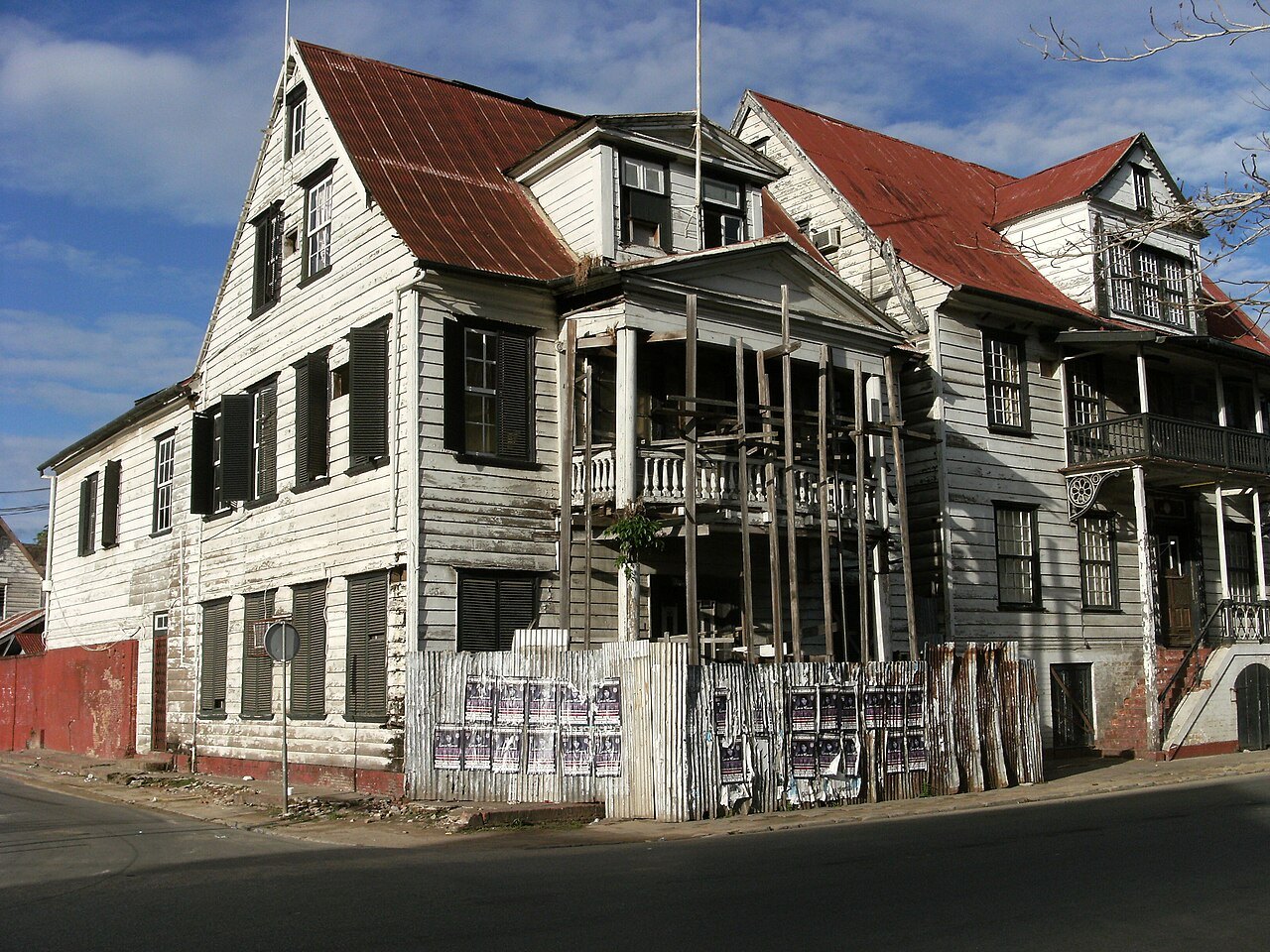
UNESCO listed the Historic Inner City of Paramaribo in 2002. Its street plan and wooden buildings reflect the adaptation of European architectural forms through local materials and skills. The Waterkant faces the Suriname River. Saints Peter and Paul Cathedral is a prominent wooden Roman Catholic cathedral. Fort Zeelandia preserves layers of colonial history and is also associated with the December Murders of 1982. The nearby Neveh Shalom Synagogue and mosque are often discussed as visible signs of religious coexistence, without implying that society has never experienced conflict.
Fort Nieuw Amsterdam stands near the meeting of the Commewijne and Suriname rivers, across from the capital’s river corridor. Farther inland, Raleigh Falls and the Voltzberg granite dome are associated with the Central Suriname Nature Reserve. Brownsberg overlooks Brokopondo Reservoir, while river journeys from Atjoni connect with Upper Suriname communities. Galibi and Bigi Pan offer different coastal landscapes. These locations illustrate the country’s geography and history; local access, conservation rules and community arrangements govern how visits take place.
People and society of Suriname
Coastal neighbourhoods, Indigenous and Maroon communities, and a large diaspora sustain varied connections.
- Where do most people in Suriname live?
- Most residents live in the northern coastal belt, especially Paramaribo and neighbouring Wanica. The forested interior has fewer settlements and a much lower population density.
- Who was Anton de Kom?
- Anton de Kom was a Surinamese writer and anticolonial activist, known for We Slaves of Suriname. He later joined the Dutch resistance and died in 1945.
- What did Anthony Nesty win in 1988?
- Anthony Nesty won Olympic gold for Suriname in the men’s 100-metre butterfly at Seoul in 1988. His swimming career remains a major part of national sporting history.
More about Suriname: people & society
Suriname’s people include Hindustani, Creole, Maroon, Javanese, Indigenous, Chinese, European and mixed-ancestry communities. These categories reflect histories of settlement, slavery, indenture and migration, but do not prescribe individual identities. Most residents live in the northern coastal belt, particularly Paramaribo and Wanica. Indigenous peoples include Kari’na, Lokono, Trio and Wayana communities. Maroon peoples include the Ndyuka, Saramaka, Matawai, Aluku, Paramaka and Kwinti, each with distinct histories and living institutions.
A substantial diaspora lives in the Netherlands, with other communities elsewhere. Family links, language, literature, music and football connect people across the Atlantic. Anton de Kom wrote We Slaves of Suriname and later participated in the Dutch resistance before his death in Nazi imprisonment in 1945. Cynthia Mc Leod’s historical fiction explores Surinamese society. Swimmer Anthony Nesty won Olympic gold in the 100-metre butterfly in 1988. Such biographies show different kinds of contribution without reducing a society to demographic rankings or a single famous person.