Facts about Libya
Discover Libya from Mediterranean ports and Roman cities to Saharan oases and rock art. Learn twenty-two reference districts, place twenty-four cities and towns, and explore seas and desert lakes with complete geographic shapes.
- Capital
- Tripoli
- Currency
- Libyan dinar (LYD)
- Official language
- Arabic
- Historical regions
- Tripolitania, Cyrenaica, Fezzan
- Independence
- 24 December 1951
- Coast
- Mediterranean Sea
Libya · 0 of 20 rounds passed
Two timed rounds per topic, 20 seconds a question
Tripoli anchors the western coast, with Zuwara towards Tunisia, Gharyan in the uplands and Misrata farther east. Across the Gulf of Sidra, Benghazi opens onto Cyrenaica and the greener Jabal al Akhdar, where Bayda and ancient Cyrene lie inland from the sea. Tobruk stands near the Egyptian border. These coastal connections contrast with the oasis routes reaching Ghadames, Sabha, Ghat and Kufra.
Fezzan’s dunes, volcanic landscapes and saline lakes add another scale to the map. Libya has no permanent natural rivers: groundwater and engineered supply networks are central to its water story. The Mediterranean continues across the whole basin beyond the country’s borders, with the gulfs of Sidra and Gabes separately selectable. Ten illustrated topics, thirty answered questions and eighty reviewed quiz questions connect the geography with people and everyday life.
Geography of Libya
Tripolitania, Cyrenaica and Fezzan connect a long Mediterranean coast with an immense Saharan interior.
- What are Libya’s three historical regions?
- Tripolitania in the west, Cyrenaica in the east and Fezzan in the southwest. These are historical regions rather than the country’s smaller municipalities.
- Does Libya have permanent natural rivers?
- No. Wadis carry water intermittently, while groundwater is crucial to settlements and agriculture. Small saline lakes survive in parts of the desert.
- What is the Great Man-Made River?
- It is a network of wells and pipelines that moves groundwater from the desert towards northern settlements and farms, rather than a natural river.
More about Libya: geography
Libya lies in North Africa between Tunisia and Algeria to the west and Egypt to the east. Niger and Chad border the south, while Sudan meets the southeast. Tripolitania is the historical western region, Cyrenaica the east and Fezzan the southwest. These broad regions differ from both the twenty-two districts in the reference map and the smaller municipalities used for local administration. Tripoli faces the sea in the northwest; Benghazi stands on the eastern side of the Gulf of Sidra.
The Sahara dominates the interior, but its landscapes include rocky plateaus, mountain ranges, gravel plains, dunes and oases. The Jabal al Akhdar, or Green Mountain, receives more rain than much of the country. Libya has no permanent natural rivers. Groundwater supports oasis settlements and irrigated fields, while the Great Man-Made River carries water through pipes from desert wellfields towards populated northern areas. It is an engineered supply network rather than an open river.
History of Libya
Saharan societies, Mediterranean cities, colonial resistance and independence belong to different chapters of Libya’s past.
- When did Libya become independent?
- Libya became independent on 24 December 1951 under King Idris. Italian colonial rule had already ended before the period of Allied administration.
- Who founded ancient Cyrene?
- Greek settlers from Thera founded Cyrene in the eastern uplands. The city later became part of the Roman world.
- What is Omar Mukhtar remembered for?
- He led resistance to Italian colonial rule, especially in Cyrenaica. He was captured and executed in 1931 and became a national symbol.
More about Libya: history
Rock art in the Acacus records communities living in changing Saharan environments long before the modern state. The Garamantes developed an oasis civilisation in Fezzan, with Garama near today’s Germa as an important centre. On the coast, Phoenician trading settlements and Greek cities followed different histories. Cyrene was founded by Greeks from Thera; Leptis Magna grew into a major Roman city. Septimius Severus, a Roman emperor born at Leptis, enlarged his hometown.
Arab conquests in the seventh century introduced new political and religious connections. Ottoman rule later linked the coastal provinces with a wider Mediterranean empire. Italy invaded in 1911, and colonial conquest met sustained resistance, including that led by Omar Mukhtar. Libya became independent on 24 December 1951 under King Idris, after a period of Allied administration. A military coup brought Muammar Gaddafi to power in 1969; an uprising and war ended his rule in 2011.
Languages of Libya
Everyday Libyan Arabic sits alongside formal Arabic and the languages of Amazigh, Tuareg and Tebu communities.
- What does the linked Arabic course teach?
- The course introduces Modern Standard Arabic, which differs from everyday Libyan spoken varieties. It provides a starting point for formal Arabic.
- Where are Amazigh languages spoken in Libya?
- Communities in Zuwara, the Nafusa Mountains, Ghadames and Awjila have Amazigh language traditions. Tuareg varieties are also part of the wider family.
- Are Tebu languages the same as Amazigh languages?
- No. Tebu linguistic traditions, including Tedaga, are distinct. Libya contains several language families and communities with their own histories.
More about Libya: language
Arabic is Libya’s official language. Modern Standard Arabic is used in formal writing, education and broadcasting, while Libyan Arabic varieties belong to everyday conversation. Speech differs between regions and communities. A phrase learned from a formal Arabic textbook may therefore sound different in a market or family conversation. The linked Worldly lessons introduce Modern Standard Arabic; they are not a dedicated course in Libyan dialect.
Amazigh languages are associated with places including Zuwara, the Nafusa Mountains, Ghadames and Awjila. Tuareg communities in the southwest use varieties of Tamahaq, part of the wider Amazigh language family. Tebu communities have their own linguistic traditions, including Tedaga; these are distinct from Amazigh languages. Migration, schooling and family histories also bring other languages into daily life. One official language label cannot describe all of Libya’s linguistic experience.
Culture of Libya
Poetry, music, weaving and shared hospitality carry regional histories into contemporary life.
- What is malouf?
- Malouf is a North African musical tradition with Andalusian connections. Libya has its own performers and repertoires alongside other forms of music.
- What is an oud?
- The oud is a plucked string instrument with a rounded body and short neck. It is a lute used in many regional musical traditions.
- Which craft is associated with Gharyan?
- Gharyan is known for pottery. Ceramic workshops and markets connect the western mountain city with a wider tradition of handmade household objects.
More about Libya: culture
Libyan cultural life includes oral poetry, storytelling, popular song and instrumental music. Malouf belongs to a North African tradition with Andalusian connections, while other repertoires reflect coastal cities, desert communities and changing urban tastes. The oud is a plucked lute used across the region. Wedding music, religious occasions and informal gatherings provide different settings for performance, and traditions continue to change through recordings, broadcasting and diaspora networks.
Woven textiles, silverwork, pottery and clothing express local skills and identities. Gharyan is associated with pottery; oasis settlements and Amazigh and Tuareg communities maintain other craft traditions. Tea and shared meals can create time for conversation and hospitality. Dress and celebrations vary with the community, occasion and individual. The photograph from Ghadames shows one local setting, rather than a single costume or custom shared by everyone in Libya.
Economy of Libya
Oil and gas connect desert production areas with coastal terminals, public finances and international markets.
- What is Libya’s currency?
- The Libyan dinar, with the international code LYD. One dinar is divided into one thousand dirhams, according to the Central Bank of Libya.
- Why do oil production changes affect Libya’s economy?
- Oil and gas provide a large share of export earnings and public revenue. Disruptions can therefore affect budgets, imports and services.
- What limits farming across much of Libya?
- Water scarcity is a major constraint. Irrigation and groundwater support production where rainfall alone is insufficient, especially around desert oases.
More about Libya: economy
Hydrocarbons dominate Libya’s exports and are central to government revenue. Oilfields in the interior connect by pipeline with coastal terminals, including facilities around the Gulf of Sidra. This dependence exposes public spending and economic activity to changes in production, international prices and political disputes. The World Bank identifies diversification and stronger institutions as major development challenges. A large public sector sits alongside private trading, services and small businesses.
Agriculture is constrained by water availability but remains important around suitable coastal areas and oases. Dates, olives and other crops link farming with local markets; fishing connects coastal communities with the Mediterranean. Ports at Tripoli, Misrata and Benghazi handle commercial traffic. The national currency is the Libyan dinar, abbreviated LYD, divided into one thousand dirhams. The central bank issues the currency; exchange rates and access to services change over time.
Politics and institutions of Libya
The legacy of 2011, competing institutions and efforts towards a political settlement shape public life.
- What does UNSMIL stand for?
- United Nations Support Mission in Libya. Its work includes supporting a Libyan-led political process and broader efforts towards stability and reconciliation.
- Does the district map show current control?
- No. It is a 2018 administrative reference map. It neither maps front lines nor represents the smaller municipalities used for local administration.
- Which event ended Gaddafi’s rule?
- The uprising and war of 2011 ended his rule. The political transition that followed has involved competing institutions and prolonged instability.
More about Libya: politics
The 2011 uprising developed into war and ended Gaddafi’s rule. The subsequent transition did not produce a durable unified political order. Rival authorities, armed groups and disputes over national institutions have shaped governance. The United Nations Support Mission in Libya, UNSMIL, works to support a Libyan-led political process, institutional unification and reconciliation. Political arrangements and officeholders can change, so historical turning points offer a more durable introduction than a fixed list of leaders.
Control of public revenue, security institutions and the conditions for elections remain connected issues. Municipalities provide another scale of government, different from the twenty-two district reference areas used in the map game. Those boundaries do not show military control or determine present access to a place. Libya belongs to organisations including the United Nations, African Union, Arab League and OPEC. Membership in one does not exclude membership in the others.
Nature and water in Libya
Desert lakes, northern uplands and coastal wetlands support very different habitats.
- Are the Ubari lakes freshwater lakes?
- The mapped lakes of Gaberoun and Mafo are saline. Their presence among dunes does not make them a general source of drinking water.
- What makes Waw an Namus distinctive?
- It is a volcanic landscape with lakes inside a desert depression. Its dark volcanic material contrasts with the surrounding Saharan terrain.
- Why are coastal wetlands important?
- They provide habitat and feeding areas for waterbirds, including migrants. Libya’s Ramsar sites recognise part of this Mediterranean wetland heritage.
More about Libya: nature & wildlife
The Sahara contains more than sand. Rocky massifs, gravel plains and dune fields create different habitats, while oases depend on access to water. Gaberoun and Mafo are small saline lakes within the Ubari sand sea. The volcanic depression at Waw an Namus holds a separate group of lakes. These shorelines are tiny compared with the country’s area, so the water map allows close zooming rather than drawing oversized lakes over the dunes.
The Jabal al Akhdar supports Mediterranean vegetation in the northeast. Coastal lagoons, including Ain Elshakika and Ain Elzarga, provide habitat for migratory and resident waterbirds and are designated Ramsar wetlands. Water scarcity, groundwater depletion and habitat damage affect conservation as well as livelihoods. Seasonal wadis can also flood violently: the absence of permanent rivers does not mean the absence of flood risk, as the September 2023 disaster in Derna demonstrated.
Food of Libya
Bazin, couscous, pasta, dates and shared tea connect the coast, oases and household kitchens.
- What is bazin made from?
- Bazin is commonly made from barley flour and water worked into a firm dough. It is served with sauce and other accompaniments.
- What is makaruna mbakbaka?
- It is a Libyan pasta dish cooked in a seasoned sauce. The pasta and other ingredients commonly cook together in one pot.
- What is makroudh?
- Makroudh is a semolina pastry often filled with dates. Variations occur across the Maghreb, including within Libyan household cooking.
More about Libya: food & cuisine
Bazin is made from barley flour worked with water into a firm dough, commonly shaped into a mound and served with sauce and accompaniments. Recipes vary, with meat, vegetables and eggs appearing in different versions. Couscous is a steamed grain preparation, while pasta dishes also have an established place in Libyan cooking. Makaruna mbakbaka cooks pasta in a seasoned sauce, often in the same pot as the other ingredients.
Shorba is a familiar soup name, with local versions using ingredients such as tomatoes, spices, meat and small pasta. Dates connect the table with oasis agriculture; olives and olive oil reflect Mediterranean farming. Makroudh is a semolina pastry commonly filled with dates. Tea is often offered in small glasses, sometimes with mint. These examples introduce a varied cuisine whose recipes depend on region, household, occasion and available ingredients.
Landmarks and heritage of Libya
Ancient coastal cities, an oasis old town and Saharan rock art offer several ways into Libya’s history.
- Where is Leptis Magna?
- Leptis Magna lies beside Khoms on Libya’s western Mediterranean coast, east of Tripoli. It is a separate archaeological site from nearby modern Khoms.
- What is distinctive about old Ghadames?
- Its oasis architecture combines covered passages with houses arranged over several levels, adapting domestic life to the desert environment.
- What do the Acacus rock-art sites record?
- Paintings and engravings record animals, human activities and changing Saharan environments across many periods, long before the modern Libyan state.
More about Libya: landmarks
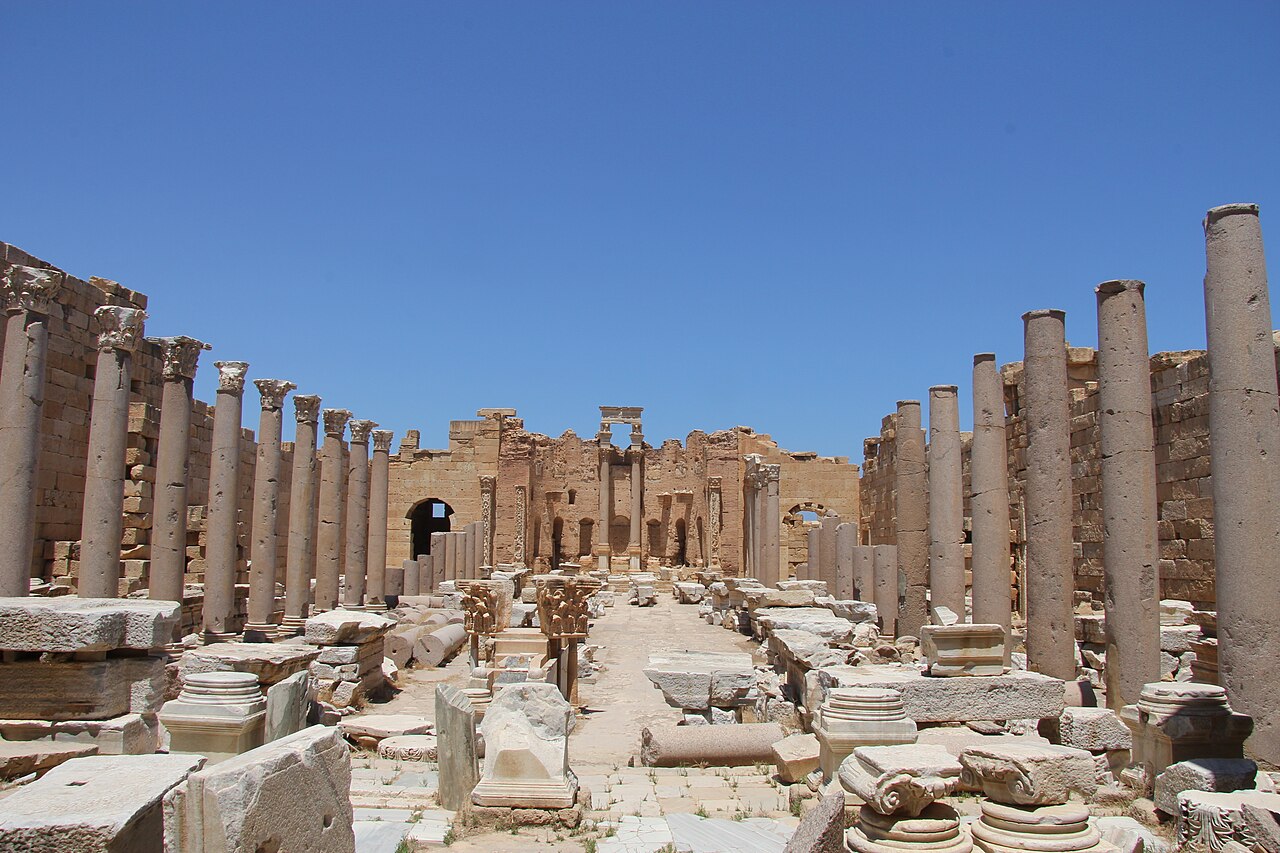
Leptis Magna, near Khoms, preserves monumental Roman streets and public buildings in a city with earlier Phoenician roots. Sabratha, west of Tripoli, developed from a trading settlement and is especially known for its Roman theatre. Cyrene lies in the eastern uplands near Shahat, with sanctuaries, tombs and public buildings from Greek and Roman periods. Each is a separate UNESCO World Heritage property, rather than three parts of one inscription.
Ghadames adds an oasis town with shaded passages and houses organised across several levels. Tadrart Acacus adds rock paintings and engravings that record changing environments and ways of life. These five properties introduce only part of Libya’s heritage. Tripoli’s Red Castle, Nalut’s granary, the old settlement of Germa and the architecture of the Nafusa Mountains tell other stories. Photographs and map pins describe places; their dates and present conditions may differ.
People and communities of Libya
Coastal neighbourhoods, oasis towns and cross-border family networks carry many forms of belonging.
- Where are many Libyan cities concentrated?
- Along the Mediterranean coastal belt. Oasis towns in the interior remain important centres with their own communities, economies and histories.
- Which communities are associated with the southwest?
- Tuareg communities are among those with strong connections to Ghat and the southwestern Sahara. The region contains several communities and identities.
- What does a Libyan diaspora mean?
- It refers to Libyans and their descendants living abroad, connected through family ties, cultural work and other relationships with Libya.
More about Libya: people & society
Many Libyans live in the coastal urban belt, where Tripoli, Misrata, Benghazi and other cities concentrate services and employment. Desert settlements have their own histories of farming, transport and trade. Arab, Amazigh, Tuareg and Tebu identities belong to a wider social landscape with overlapping family, local and national connections. Community names do not define fixed political views, and neither district boundaries nor broad historical regions map neatly onto people’s identities.
Migration connects Libya with neighbouring countries and communities farther away. Libyans abroad maintain family, professional and cultural ties, while migrants and refugees within Libya have varied experiences and backgrounds. Writers and artists also carry these histories across borders. Ibrahim al-Koni’s fiction draws on Saharan and Tuareg worlds; Hisham Matar writes about family, exile and memory. Omar Mukhtar’s resistance remains a prominent reference in national remembrance, across very different generations and life experiences.