Facts about Zimbabwe
Explore Zimbabwe from Harare and Bulawayo to Great Zimbabwe, Victoria Falls and the Eastern Highlands. Sixteen city and town locations, twelve sights and ten illustrated topics connect its geography with history, languages and everyday life.
- Capital
- Harare
- Population
- 15,178,979 (2022 census)
- Area
- 390,757 km²
- Recognised languages
- 16 (2013 Constitution)
- Currency
- Zimbabwe Gold (ZiG); US dollars also used
- Independence
- 18 April 1980
Zimbabwe · 0 of 20 rounds passed
Two timed rounds per topic, 20 seconds a question
The central plateau links Harare, Kadoma, Kwekwe and Gweru, with Bulawayo in the southwest. Mutare faces the Eastern Highlands; Masvingo is near the medieval city of Great Zimbabwe. Chinhoyi, Bindura and Marondera introduce the three Mashonaland provincial capitals.
Victoria Falls and Kariba orient the northern Zambezi country, while Beitbridge marks the southern Limpopo crossing. Hwange, Mana Pools and Gonarezhou reveal different lowland habitats. The map marks settlement centres and representative sights, separately from administrative or protected-area boundaries.
Geography of Zimbabwe
A central plateau between the Zambezi, Limpopo and Eastern Highlands.
- Which country forms Zimbabwe’s longest boundary?
- Mozambique, along the eastern side.
- What is the highest mountain?
- Mount Nyangani, 2,592 metres, in the Eastern Highlands.
- Is Lake Kariba a natural lake?
- No. It is a reservoir created by damming the Zambezi, shared with Zambia.
More about Zimbabwe: geography
Zimbabwe is landlocked in southern Africa, bordering Zambia, Mozambique, South Africa and Botswana. Mozambique forms its longest international boundary, along the east. The Zambezi follows much of the northern border, while the Limpopo marks the southern border with South Africa. Harare, the capital and largest city, sits on the central plateau; Bulawayo is a major centre in the southwest. The country covers about 390,757 square kilometres.
The Highveld forms a higher central belt, descending towards hotter lowveld areas. The Eastern Highlands rise along Mozambique, with Mount Nyangani reaching 2,592 metres. The Great Dyke is an elongated geological intrusion rich in chromium and platinum-group metals. Lake Kariba is a reservoir on the Zambezi, shared with Zambia. Summer rainfall, elevation and drought shape farming and water availability; the eastern mountains and dry southeastern lowveld have markedly different environments.
History of Zimbabwe
Stone-built states, colonial rule and independence on 18 April 1980.
- Who built Great Zimbabwe?
- A medieval Shona-speaking society, long before European colonial rule.
- When did Zimbabwe become independent?
- 18 April 1980, following the Lancaster House negotiations.
- Was Mugabe the first president?
- No. Canaan Banana was the first president; Mugabe initially served as prime minister.
More about Zimbabwe: history
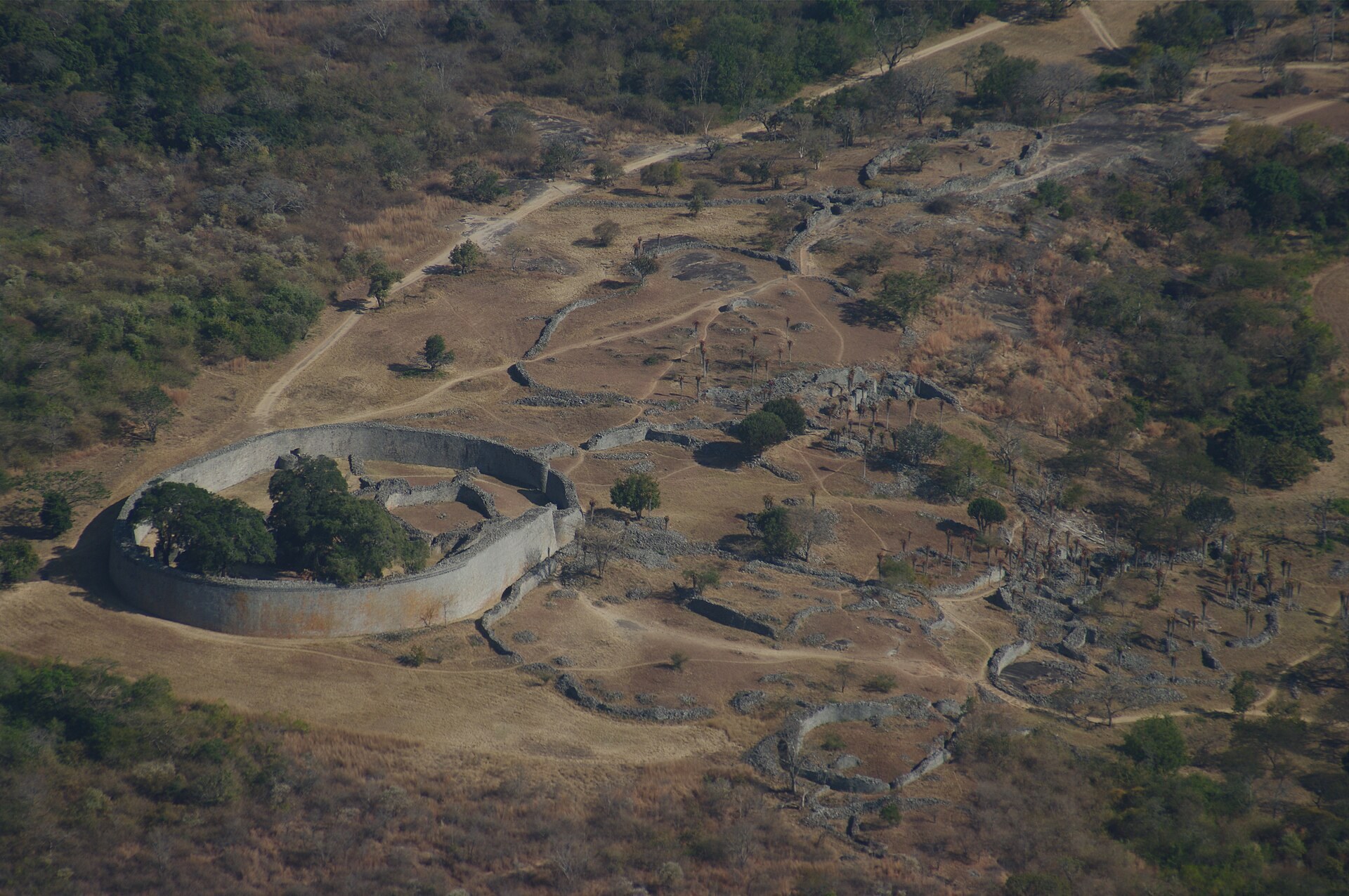
Great Zimbabwe flourished between the eleventh and fifteenth centuries as a major settlement of a Shona-speaking society, connected through trade to the Indian Ocean coast. Its dry-stone walls give the modern country its name. Later regional states included Mutapa, Torwa and Rozvi polities. In the nineteenth century, Mzilikazi established the Ndebele kingdom in the southwest. These histories overlap and should not be reduced to a single uninterrupted kingdom.
The British South Africa Company imposed colonial rule in the 1890s. Southern Rhodesia became a self-governing British colony in 1923 under white minority rule. Ian Smith’s government issued a unilateral declaration of independence in 1965, without international recognition. The liberation war and negotiations led to the Lancaster House Agreement in 1979 and recognised independence on 18 April 1980. Canaan Banana became president and Robert Mugabe prime minister. Mugabe became executive president in 1987 and resigned in November 2017 after military intervention.
Shona, Ndebele and Zimbabwe’s languages
Sixteen constitutionally recognised languages and a place to begin Shona.
- How many languages does the Constitution recognise?
- Sixteen, including sign language.
- Where is Ndebele especially important?
- In Matabeleland and Bulawayo, as well as communities elsewhere.
- How can you say thank you in Shona?
- Tatenda or mazvita; wording depends on context.
More about Zimbabwe: language
Section 6 of Zimbabwe’s 2013 Constitution recognises sixteen languages: Chewa, Chibarwe, English, Kalanga, Koisan, Nambya, Ndau, Ndebele, Shangani, Shona, sign language, Sotho, Tonga, Tswana, Venda and Xhosa. This is the constitutional wording, including its broad labels. Shona varieties are widely spoken; Ndebele is particularly important in Matabeleland and Bulawayo. English has a prominent role in government, business and education, without replacing people’s home languages.
Shona and Ndebele are Bantu languages within the Niger–Congo family. Shona itself encompasses varieties with different regional histories; the constitutional list separately recognises Ndau. Mhoro is a Shona greeting, and makadii is a respectful way to ask how someone is. Tatenda and mazvita express thanks. In Ndebele, ngiyabonga means “I thank you”, while siyabonga means “we thank you”. The linked Shona lessons offer one starting point; they do not stand for all of Zimbabwe’s languages.
Culture of Zimbabwe
Mbira, stone sculpture, literature and changing urban music.
- What kind of instrument is a mbira?
- A lamellophone with metal keys on a wooden soundboard.
- Who is associated with chimurenga music?
- Thomas Mapfumo, who adapted mbira-related patterns for electric ensembles.
- Does one tradition describe all Zimbabweans?
- No. Practices vary between communities, generations and households.
More about Zimbabwe: culture
Mbira instruments have metal keys mounted on a wooden soundboard, often played inside a resonating gourd. Mbira music can accompany ceremonies, storytelling and everyday performance. UNESCO inscribed the art of crafting and playing mbira/sansi in Malawi and Zimbabwe in 2020. Contemporary Zimbabwean stone sculpture became internationally prominent in the twentieth century; artists use different stones and styles rather than one uniform national tradition.
Thomas Mapfumo helped develop chimurenga music, bringing mbira-inspired patterns into electric popular music. Oliver Mtukudzi’s distinctive music reached audiences far beyond Zimbabwe. Sungura, gospel, jazz and Zimdancehall are also part of a changing musical landscape. Totems, family relationships and ancestral traditions matter in many communities, alongside Christianity and other beliefs. Lobola or roora refers to negotiated marriage exchanges between families; practices differ, and neither one faith nor one custom describes every Zimbabwean.
Economy of Zimbabwe
Mining, tobacco, services and the everyday effects of currency change.
- What does ZiG stand for?
- Zimbabwe Gold, introduced in April 2024.
- When was the 100-trillion-dollar note issued?
- In January 2009, after the severe hyperinflation of 2008.
- Which crop is a major agricultural export?
- Tobacco; maize is especially important as a staple food crop.
More about Zimbabwe: economy
Gold, platinum-group metals and other minerals connect Zimbabwe to international markets. Tobacco is a major agricultural export, while maize is an important staple crop. Commercial and smallholder farming, manufacturing, services, informal trade and remittances all contribute to livelihoods. Harare is a major commercial centre, Bulawayo has a long industrial history, and tourism supports places around Victoria Falls and national parks. Drought, power shortages and access to finance can constrain production.
Hyperinflation disrupted the Zimbabwe dollar in 2008; the famous 100-trillion-dollar note was issued in January 2009. Foreign currencies, especially the US dollar, became widely used. The Reserve Bank introduced Zimbabwe Gold, abbreviated ZiG, in April 2024 as a currency backed by reserves including gold and foreign currency. US dollars also circulate. Land redistribution accelerated under the fast-track programme launched in 2000, addressing colonial land inequalities while bringing major disruption, conflict and continuing debate over tenure, production and compensation.
Politics of Zimbabwe
A presidency, two parliamentary chambers and a contested political history.
- What are Parliament’s two chambers?
- The National Assembly and the Senate.
- Who became president in November 2017?
- Emmerson Mnangagwa, following Robert Mugabe’s resignation.
- When did the power-sharing government begin?
- In 2009, after the disputed 2008 elections and negotiations.
More about Zimbabwe: politics
Zimbabwe is a republic with a president who serves as head of state and government. Parliament consists of the National Assembly and Senate. The 2013 Constitution sets out institutions, rights and devolved government. The country has ten provinces for administrative purposes, including the metropolitan provinces of Harare and Bulawayo. ZANU-PF has roots in the liberation movement and has dominated national government. The 1987 Unity Accord brought ZANU and PF-ZAPU together.
Emmerson Mnangagwa became president in November 2017 after Robert Mugabe resigned. Morgan Tsvangirai led the Movement for Democratic Change and served as prime minister in the power-sharing government formed in 2009 after the disputed 2008 elections. Gukurahundi refers to state violence in the 1980s in Matabeleland and the Midlands, in which many thousands of civilians were killed; Ndebele-speaking communities were particularly affected. Elections, accountability, public services and constitutional rights remain subjects of debate. These dated events should be distinguished from claims about future officeholders or election outcomes.
Nature & Wildlife of Zimbabwe
Hwange’s woodlands, Zambezi floodplains and Eastern Highland habitats.
- Which national park is Zimbabwe’s largest?
- Hwange National Park, in the west.
- Which river runs beside Mana Pools?
- The Zambezi.
- Are the Eastern Highlands like the lowveld?
- No. Elevation brings cooler conditions and distinct grassland and forest habitats.
More about Zimbabwe: nature & wildlife
Hwange, the largest national park in Zimbabwe, protects woodlands and grasslands in the west and is well known for elephants. Mana Pools lies beside the Zambezi, where floodplains, river channels and pools support rich wildlife. The World Heritage property also includes Sapi and Chewore safari areas. Gonarezhou in the southeast forms part of a wider transfrontier conservation landscape with Mozambique and South Africa.
Matobo’s granite hills support raptors and protected rhinoceros populations. In the Eastern Highlands, montane grasslands and forests shelter species absent from the hotter lowveld. Miombo and mopane woodlands form extensive habitats elsewhere. African wild dogs occur in landscapes including Hwange and the Zambezi Valley. Conservation involves habitat connectivity, anti-poaching work, tourism, water availability and the costs borne by neighbouring communities. Floods, fire and seasonal drought change the landscape; a map pin marks a learning location rather than an animal sighting or park boundary.
Food & Cuisine of Zimbabwe
Sadza, leafy vegetables, peanut sauces and meals shaped by home and season.
- What is sadza?
- A thick grain porridge, commonly made from maize meal.
- What is dovi?
- Peanut butter, used in sauces, vegetables and other dishes.
- Are macimbi worms?
- No. They are edible mopane moth caterpillars.
More about Zimbabwe: food & cuisine
Sadza is a thick cooked porridge, commonly made from maize meal, though millet and sorghum also have important food traditions. It is served with accompaniments such as leafy greens, beans, meat or fish. In Ndebele it is commonly called isitshwala. Bota is a thinner porridge often eaten for breakfast. Peanut butter, dovi in Shona, adds flavour and richness to vegetables, porridges and sauces.
Mopane caterpillars, called madora or macimbi, are harvested, dried and cooked in some regions; they are insects rather than worms. Kapenta are small fish associated with Lake Kariba fisheries. Roasted or boiled maize, chibage, is a familiar snack, while maputi are popped maize. Mutakura combines boiled grains and pulses. Food varies with community, season, income and household preference: urban restaurants, markets and home kitchens are as much part of Zimbabwean food as the dishes presented as national staples.
Landmarks of Zimbabwe
Five World Heritage properties, stone cities and the spray of Victoria Falls.
- How many World Heritage properties does Zimbabwe have?
- Five, including Victoria Falls shared with Zambia.
- What is distinctive about Great Zimbabwe?
- Its dry-stone architecture, including the Great Enclosure and conical tower.
- Is Victoria Falls entirely in Zimbabwe?
- No. The waterfall lies on the Zambezi boundary with Zambia.
More about Zimbabwe: landmarks
Zimbabwe has five UNESCO World Heritage properties: Great Zimbabwe, Khami, Matobo Hills, Mana Pools with Sapi and Chewore, and Mosi-oa-Tunya / Victoria Falls, shared with Zambia. Great Zimbabwe’s Great Enclosure and conical tower are part of a much larger medieval settlement. The soapstone Zimbabwe Birds found at the site inspired the national emblem. Khami, west of Bulawayo, developed as a Torwa capital after Great Zimbabwe declined.
Victoria Falls carries the Zambezi into a deep gorge along the Zambia border. The Victoria Falls Bridge crosses below the falls, linking the two countries. Matobo is both a dramatic granite landscape and a place of rock art, sacred associations and layered histories. Kariba Dam, completed in 1959, supplies hydropower and created a reservoir whose construction displaced communities, including Tonga people. The Eastern Highlands offer a different landscape around Nyanga and Chimanimani. Broad landscapes use representative pins; these do not define protected-area boundaries.
People & Society of Zimbabwe
A dated census, diverse communities, writers, musicians and sporting achievements.
- What did the 2022 census count?
- 15,178,979 people; it is not a current estimate.
- Who wrote Nervous Conditions?
- Tsitsi Dangarembga.
- How many Olympic medals did Kirsty Coventry win?
- Seven in swimming, across Athens 2004 and Beijing 2008.
More about Zimbabwe: people & society
Zimbabwe’s 2022 census counted 15,178,979 people. This is a dated census count, not a current population estimate. Harare and Bulawayo are major urban centres, while towns, farming districts and cross-border connections shape settlement and mobility. Shona-speaking and Ndebele-speaking populations are prominent, alongside Tonga, Kalanga, Venda, Shangani, Nambya, Chewa and other communities. Citizenship, language and ancestry are related in varied ways rather than interchangeable labels.
Writers include Tsitsi Dangarembga, author of Nervous Conditions, Dambudzo Marechera, author of The House of Hunger, and NoViolet Bulawayo, author of We Need New Names. Oliver Mtukudzi and Thomas Mapfumo helped bring Zimbabwean music to international audiences. Kirsty Coventry won seven Olympic swimming medals across the 2004 and 2008 Games. Nick Price held golf’s world number one ranking for a total of 43 weeks. Sporting and cultural achievements form one part of wider lives shaped by work, education, family, migration and community.