Facts about Uganda
Uganda connects the Great Lakes and the Nile with highland farms, forest habitats and growing cities. Explore sixteen cities and towns, twelve heritage and landscape locations and ten illustrated topics, from Kampala and Buganda’s royal heritage to the Rwenzori Mountains and the northeastern savannas.
- Capital
- Kampala
- Region
- East Africa
- Neighbours
- 5 countries
- Official languages
- English and Swahili
- Currency
- Ugandan shilling (UGX)
- Independence
- 9 October 1962
Uganda · 0 of 20 rounds passed
Two timed rounds per topic, 20 seconds a question
Kampala stands near Lake Victoria, with Entebbe on a peninsula to the southwest and Jinja at the Victoria Nile’s outlet to the east. Mbale faces Mount Elgon, Soroti serves Teso and Moroto orients the northeastern Karamoja region. Gulu, Lira, Kitgum and Arua introduce different parts of northern Uganda.
Hoima and Masindi connect with Bunyoro and Lake Albert country. Fort Portal and Kasese sit near the western mountains, while Mbarara and Kabale anchor southwestern routes. Bwindi, the Rwenzori, Murchison Falls and Kidepo reveal contrasting habitats. City pins mark approximate settlement centres; large parks use representative sight locations.
Geography of Uganda
Great Lakes, the Nile and highlands on both sides of the equator.
- Which countries border Uganda?
- South Sudan, Kenya, Tanzania, Rwanda and the Democratic Republic of the Congo.
- Is Uganda on the coast?
- No. It is landlocked, although it has extensive shores on large inland lakes.
- What makes Jinja important to the Nile?
- The Victoria Nile flows out of Lake Victoria near Jinja; more distant Nile headwaters lie beyond Uganda.
More about Uganda: geography
Uganda is a landlocked East African country bordering South Sudan, Kenya, Tanzania, Rwanda and the Democratic Republic of the Congo. Kampala, the capital, lies near Lake Victoria’s northern shore. Much of the country is an elevated plateau, with the Rwenzori Mountains on the western frontier and Mount Elgon on the Kenyan border. Altitude moderates temperatures, but rainfall and growing conditions differ between the lake basin, mountains and drier northeastern Karamoja.
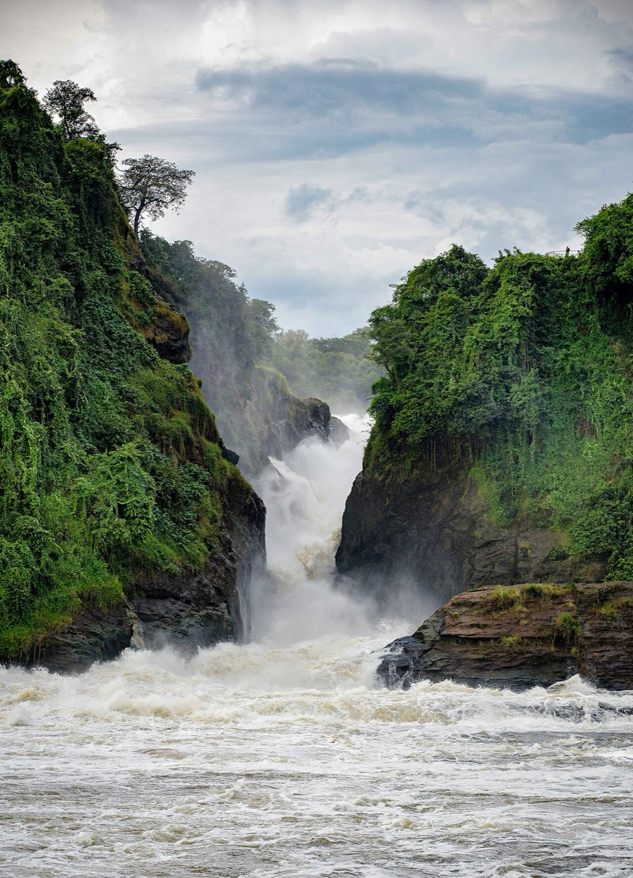
Lake Victoria is shared with Kenya and Tanzania; Lake Albert and Lake Edward straddle the DRC frontier. The Victoria Nile leaves Lake Victoria near Jinja, passes through Lake Kyoga and plunges over Murchison Falls before entering Lake Albert. The river continues north towards South Sudan as the Albert Nile. Jinja marks a major lake outlet in the Nile system, while the river’s more distant headwaters extend beyond Uganda. Lake George, western crater lakes and extensive wetlands add other freshwater environments.
History of Uganda
Regional kingdoms, colonial boundaries and independence on 9 October 1962.
- When did Uganda become independent?
- On 9 October 1962, from Britain.
- Are Uganda and Buganda the same thing?
- No. Buganda is a historic kingdom within Uganda, whose communities have many different political histories.
- What happened in 1972?
- Idi Amin ordered the expulsion of many Asian Ugandans, uprooting families and disrupting commerce.
More about Uganda: history
Long before the modern state, farming, herding, ironworking and trade sustained different societies across this region. Bunyoro, Buganda, Ankole and Toro developed royal institutions, while other communities organised political life in different ways. Buganda grew in influence during the nineteenth century. Traders and religious missions connected the interior with wider Indian Ocean networks. Britain declared the Uganda Protectorate in 1894 and extended colonial control through treaties, military force and alliances that changed landholding and political authority.
Uganda became independent on 9 October 1962 with Milton Obote as prime minister. Edward Mutesa II, the Kabaka of Buganda, became president in 1963. The 1966 political crisis and the 1967 constitution ended the earlier constitutional arrangement and abolished kingdoms. Idi Amin seized power in 1971; his rule brought mass killing and the expulsion of many Asian Ugandans in 1972. His government fell in 1979. Further conflict preceded the National Resistance Movement’s takeover in 1986. Traditional institutions were restored in 1993 with cultural roles, distinct from national government.
English, Swahili and Uganda’s languages
English and Swahili alongside Luganda and many regional languages.
- What are Uganda’s official languages?
- English and Swahili; Swahili is constitutionally recognised as the second official language.
- Which language is associated with Buganda?
- Luganda, widely used around Kampala and beyond the kingdom.
- Do the linked Swahili lessons cover all Ugandan languages?
- No. They introduce Swahili, one part of a much wider multilingual landscape.
More about Uganda: language
English is Uganda’s official language, and the Constitution recognises Swahili as the second official language. English is prominent in law, government and formal education. Luganda, a Bantu language associated with Buganda, is widely used around Kampala and in trade and broadcasting beyond it. Official status does not mean every resident speaks a language, and Swahili’s everyday use differs between communities, generations and occupations.
Runyankole, Rukiga, Runyoro, Rutooro, Lusoga and Lugisu are among the country’s Bantu languages. Acholi, Lango, Ateso and related languages belong to Nilotic groupings, while Lugbara belongs to the Central Sudanic family. People may use several languages across home, school and work. In Luganda, oli otya? asks one person how they are, and webale means thank you. Worldly’s linked Swahili lessons introduce a regional language shared across East Africa; they are one beginning rather than a substitute for Uganda’s local languages.
Culture of Uganda
Barkcloth, royal performance and contemporary urban arts.
- How is barkcloth made?
- Bark from the mutuba tree is repeatedly beaten and worked into fabric.
- When did UNESCO recognise barkcloth making?
- It was proclaimed in 2005 and inscribed on the Representative List in 2008.
- Is there one Ugandan dance tradition?
- No. Different communities maintain distinct musical and dance traditions, alongside contemporary forms.
More about Uganda: culture
Barkcloth making is a longstanding craft of the Baganda. Artisans harvest bark from the mutuba tree, then beat and work it into a soft fabric; the tree can regenerate its bark when carefully protected. UNESCO proclaimed the tradition in 2005 and inscribed it on the Representative List of the Intangible Cultural Heritage of Humanity in 2008. Barkcloth is connected with ceremonial life and contemporary design, rather than being the everyday clothing of all Ugandans.
Music and dance differ across communities. Buganda’s royal drumming traditions, Acholi dances and Ankole performances have their own histories. Ensembles such as the Ndere Troupe bring several traditions to public stages. Gomesi dresses and kanzu tunics are associated especially with Buganda and formal occasions, alongside many other styles of dress. Kampala’s recording studios, visual arts, theatre and independent film production add contemporary voices. Football is widely followed, while running, boxing and other sports also shape public culture.
Economy of Uganda
Coffee farms, urban services and trade through East Africa.
- What is Uganda’s currency?
- The Ugandan shilling, with international code UGX.
- Which coffee types grow in Uganda?
- Both robusta and arabica, suited to different elevations and conditions.
- Why do neighbouring seaports matter?
- Uganda is landlocked, so overseas trade relies on transport corridors through neighbouring countries.
More about Uganda: economy
Agriculture supports many Ugandan households, through food crops, livestock and commercial production. Cooking bananas, cassava, maize, beans and other crops reflect different regional environments. Coffee is a major export: robusta is important in many lower and middle elevation areas, while arabica grows in highland districts including the Mount Elgon slopes. Tea, fish and horticultural products also reach markets. Rainfall, access to land, transport and changing prices affect farm incomes.
Kampala concentrates government, finance, trade and other services. Jinja has an industrial history linked to the Nile and hydroelectric power, while regional cities serve surrounding farms and cross-border commerce. Tourism draws on heritage and protected landscapes. The Ugandan shilling, code UGX, is the currency; mobile money is part of everyday payments. Petroleum development around Lake Albert raises questions about revenue, land, livelihoods and ecosystems. Uganda’s landlocked position makes road and rail connections through Kenya and Tanzania important for access to seaports.
Politics of Uganda
A republic with elected institutions, local government and cultural kingdoms.
- Which constitution underpins the republic?
- The 1995 Constitution, with later amendments.
- Does the Kabaka govern Uganda?
- No. The Kabaka is Buganda’s traditional cultural leader; national governmental authority belongs to the republic’s institutions.
- When was multiparty politics restored?
- Following a referendum in 2005.
More about Uganda: politics
Uganda is a republic governed under the 1995 Constitution, as amended. The president is head of state and government, and Parliament is the national legislature. The judiciary interprets the law. Local government includes districts and urban authorities; Kampala has a distinct capital-city administration. The number and boundaries of local units have changed over time, so the city map uses settlement centres rather than presenting a fixed district map.
The National Resistance Movement has dominated national politics since taking power in 1986. A 2005 referendum restored multiparty politics after the Movement system. Constitutional changes removed presidential term limits in 2005 and the presidential age limit in 2017. Elections, civic freedoms, accountability and relations between central and local government remain contested. Traditional leaders such as Buganda’s Kabaka have constitutionally recognised cultural roles; they are not the national executive and may not exercise governmental administrative or legislative powers as traditional leaders.
Nature & Wildlife of Uganda
Mountain gorillas, savanna wildlife and bird-rich wetlands.
- Where are mountain gorillas protected in Uganda?
- In Bwindi Impenetrable and Mgahinga Gorilla national parks.
- Is the shoebill a true stork?
- No. It belongs to its own family, Balaenicipitidae.
- Which park protects a dry northeastern landscape?
- Kidepo Valley National Park, near the South Sudan and Kenyan frontiers.
More about Uganda: nature & wildlife
Uganda’s habitats range from western forests and mountain slopes to savannas, lakes and wetlands. Bwindi Impenetrable and Mgahinga Gorilla national parks protect mountain gorilla habitat. Kibale is known for chimpanzees and other primates. Queen Elizabeth National Park includes savanna, crater lakes and the Kazinga Channel between Lake Edward and Lake George. Murchison Falls National Park combines Nile river habitats with woodland and grassland.
Kidepo Valley protects a drier northeastern landscape, while the Rwenzori rise through montane forest, bamboo and high-elevation vegetation. Wetlands such as Mabamba support shoebills and other waterbirds. The shoebill is not a true stork, despite that familiar nickname. Conservation involves neighbouring communities, land use and livelihoods as well as wildlife protection. Guided gorilla visits require permits and health precautions; a photograph or map pin does not promise access or a wildlife sighting.
Food & Cuisine of Uganda
Steamed cooking bananas, groundnut sauces and rolex street food.
- What is matooke?
- A preparation of green cooking bananas, often steamed and mashed.
- What is a Ugandan rolex?
- An omelette rolled inside a chapati, often with vegetables.
- Must luwombo contain groundnut sauce?
- No. Banana-leaf parcels can contain different ingredients and sauces.
More about Uganda: food & cuisine
Matooke, also spelled matoke, uses green cooking bananas, often steamed in banana leaves and softened or mashed. It is particularly important in the central and western country. Groundnut sauces, beans, greens, fish and meat provide different accompaniments. Posho is a firm maize-flour porridge; millet, sorghum, cassava, sweet potatoes and rice are also important in different regions. No single staple describes every Ugandan household.
Luwombo is associated with Buganda: ingredients such as chicken, meat, mushrooms or groundnut sauce are steamed in banana-leaf parcels. A rolex wraps an omelette in chapati, often with vegetables, and is a familiar street food. Muchomo means roasted meat, commonly sold on skewers. Nsenene, seasonal edible bush crickets, are enjoyed in some communities. Lake fish, dairy foods and local vegetables add regional variety. Religious observance, income and personal preferences influence what people cook and share.
Landmarks of Uganda
Kasubi’s royal heritage, the Nile and forested mountain landscapes.
- Which kingdom is associated with Kasubi?
- Buganda; Kasubi is a royal burial place and centre of living heritage.
- Which Ugandan natural sites have World Heritage status?
- Bwindi Impenetrable National Park and Rwenzori Mountains National Park.
- Are Nyero’s paintings dated precisely?
- No. Their chronology and attribution remain subjects of research.
More about Uganda: landmarks
The Tombs of Buganda Kings at Kasubi in Kampala are a UNESCO World Heritage property and a living centre of royal heritage. A major fire in 2010 led to a long reconstruction programme; the site was removed from the List of World Heritage in Danger in 2023. Namugongo’s shrines commemorate Christian martyrs killed in the nineteenth century, and Uganda National Mosque overlooks Kampala from Old Kampala hill. Nyero’s rock shelters near Kumi preserve geometric paintings whose chronology remains a subject of research.
Bwindi Impenetrable National Park and Rwenzori Mountains National Park are Uganda’s two natural World Heritage properties. Murchison Falls narrows the Victoria Nile into a dramatic gorge, and Jinja marks its outlet from Lake Victoria. Sipi Falls lies on Mount Elgon’s western slopes. Lake Bunyonyi’s islands, the Semuliki lowlands and the Kazinga Channel reveal further landscapes. The selected sight pins identify representative locations; large parks extend beyond a single point, and the map is not a guide to entrances or routes.
People & Society of Uganda
Overlapping identities, regional cities and connections across borders.
- Does one ethnic label describe all Ugandans?
- No. Many communities and overlapping personal identities contribute to national life.
- Which neighbours are important countries of origin for refugees?
- South Sudan and the Democratic Republic of the Congo, among others.
- Who wrote Song of Lawino?
- Okot p’Bitek, whose work draws on Acholi language and cultural experience.
More about Uganda: people & society
Uganda’s population includes Baganda, Banyankole, Basoga, Bakiga, Iteso, Langi, Acholi, Lugbara, Bagisu and many other communities. These names connect with languages, histories and places, but do not determine an individual’s occupation or beliefs. Kampala draws people from across the country, while Gulu, Arua, Lira, Mbarara, Mbale and other cities connect regional economies with rural homes. Families often maintain strong ties between town and countryside.
Christianity and Islam are major religious traditions, alongside varied other beliefs and practices. Uganda has a large young population, making education, employment and public services central concerns. It also hosts refugees from neighbouring countries, including South Sudan and the DRC, whose circumstances vary between settlements and urban communities. Asian Ugandan families have histories of trade, expulsion and return. Writers such as Okot p’Bitek and athletes such as Joshua Cheptegei offer different examples of Uganda’s contributions to world culture and sport.