Facts about Tajikistan
Explore Tajikistan from Dushanbe’s parks and Khujand’s riverside markets to Sogdian ruins, the Fann Mountains and the high Pamirs. Learn its administrative areas, cities, waters and sixteen sights, discover ten illustrated topics and begin speaking Tajik.
- Capital
- Dushanbe
- Population
- 10.8 million, 2025 estimate
- Highest peak
- Ismoil Somoni, 7,495 m
- Currency
- Somoni (TJS)
- State language
- Tajik
- Administrative areas
- 5, with different statuses
Tajikistan · 0 of 20 rounds passed
Two timed rounds per topic, 20 seconds a question
Tajikistan is a landlocked Central Asian country bordering Afghanistan, Uzbekistan, Kyrgyzstan and China. Mountains shape most of its territory, but everyday life also follows cultivated valleys: the Hisor valley around Dushanbe, the northern Fergana Valley around Khujand, the Zarafshan valley and the warmer lowlands of Khatlon. The Pamirs occupy much of the east, where high plateaux contrast with deeply cut river valleys.
The country’s five top-level administrative areas have different statuses: Sughd and Khatlon regions, autonomous Gorno-Badakhshan, the Districts of Republican Subordination and separate Dushanbe. The World Bank’s 2025 population estimate is about 10.8 million. Persian literary traditions, Sogdian archaeology, hydropower, migration and the lives of many language communities connect these landscapes with a much wider world.
Geography of Tajikistan
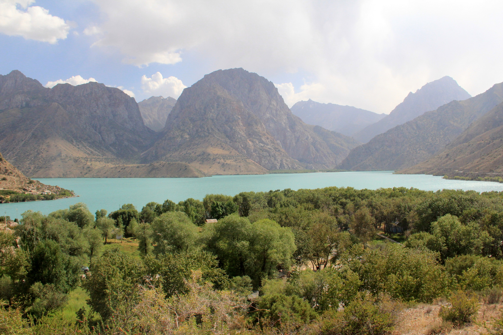
Pamir heights, Fann Mountain lakes and cultivated valleys in landlocked Central Asia.
- Which countries border Tajikistan?
- Afghanistan, Uzbekistan, Kyrgyzstan and China. Tajikistan is landlocked, with the Pamirs in the east and important inhabited valleys farther west and north.
- Are Karakul and Sarez the same lake?
- No. Karakul is the largest natural lake by surface area. Sarez formed after a landslide blocked the Bartang river system during an earthquake in 1911.
- Which river separates Tajikistan from Afghanistan?
- The Panj follows much of the frontier. It meets the Vakhsh to form the Amu Darya. The northern Syr Darya is a different river system.
More about Tajikistan: geography
Mountains cover roughly 93 percent of Tajikistan. The Pamirs dominate the east; the Fann Mountains and other western ranges separate inhabited valleys. Ismoil Somoni Peak rises to 7,495 metres. Khujand sits in the Tajik portion of the Fergana Valley, which is shared with Uzbekistan and Kyrgyzstan. Dushanbe lies farther south in the Hisor valley.
The Panj marks much of the Afghan frontier and joins the Vakhsh to form the Amu Darya. The Syr Darya crosses the north, while the Zarafshan flows west towards Uzbekistan. Karakul is the largest natural lake by surface area. Sarez formed behind an earthquake-triggered landslide in 1911; it is a different lake. Iskanderkul lies in the Fann Mountains. Elevation and difficult terrain make map distance a poor guide to journey time.
History of Tajikistan
Sogdian towns, Persian literary worlds, Soviet transformation and independence in 1991.
- When did Tajikistan become independent?
- On 9 September 1991, as the Soviet Union was breaking up. The country had become a separate Soviet republic in 1929, after an earlier autonomous period within the Uzbek republic.
- What happened during the 1990s?
- Civil war from 1992 to 1997 caused widespread loss of life and displacement. A peace agreement in 1997 ended the principal conflict, with lasting effects on politics and society.
- Why are the Samanids important to Tajik history?
- Their ninth- and tenth-century state supported Persian-language culture and literature. It is central to Tajik historical memory, although its cities and territory crossed modern national borders.
More about Tajikistan: history
Sarazm preserves evidence of settlement and exchange from the fourth and third millennia BCE. Ancient Panjakent offers a later view of Sogdian urban life, linked to the Silk Roads. Persian-language literature flourished under the Samanids in the ninth and tenth centuries, with Rudaki among its foundational poets. These cultural worlds crossed today’s national borders; Samanid Bukhara is now in Uzbekistan.
Russian imperial expansion and Soviet rule reshaped the region. A Tajik autonomous republic was established within the Uzbek Soviet republic in 1924, followed by a separate Tajik Soviet republic in 1929. Independence came on 9 September 1991. Civil war from 1992 to 1997 caused extensive suffering and displacement. The 1997 peace agreement ended the principal conflict, although its consequences continued to shape institutions and family histories.
Language of Tajikistan
A Persian variety written in Cyrillic, alongside Uzbek, Russian, Yaghnobi and Pamiri languages.
- Is Tajik a Turkic language?
- No. Tajik is a variety of Persian in the Iranian branch of the Indo-European family. Uzbek and Kyrgyz, also spoken in Tajikistan, are Turkic languages.
- Which alphabet does Tajik use?
- The standard written language in Tajikistan uses Cyrillic. This distinguishes its writing system from the Persian-based scripts commonly used for Persian in Iran and Afghanistan.
- Does everyone in the Pamirs speak Tajik at home?
- No. Several distinct Pamiri languages are used, alongside Tajik, Kyrgyz and other languages. The linked course teaches Tajik and does not represent a Pamiri language course.
More about Tajikistan: language
Tajik is an Iranian language in the Indo-European family and a variety of Persian. Its standard written form uses Cyrillic, unlike the Persian-based scripts used in Iran and Afghanistan. Tajik is the state language. The constitution gives Russian a role as the language of interethnic communication; that is a different designation from state language.
Uzbek is widely spoken in some communities. Yaghnobi and several Pamiri languages belong to the Eastern Iranian group and are distinct from Tajik. Kyrgyz is also used, particularly in the eastern Pamirs. Salom is a common hello, and tashakkur means thank you. The linked lessons introduce Tajik with Cyrillic spelling and pronunciation guidance; they do not teach all the country’s languages.
Culture of Tajikistan
Navruz, Chakan embroidery and music shared across Central Asian cultural worlds.
- What is Chakan embroidery?
- A tradition of sewing colourful floral and symbolic designs onto clothing and household textiles. UNESCO inscribed Chakan embroidery from Tajikistan in 2018.
- What is Shashmaqom?
- A classical vocal and instrumental musical tradition combining music and poetry, shared by Tajikistan and Uzbekistan. It is distinct from the Falak tradition also associated with Tajikistan.
- What does Navruz celebrate?
- Spring renewal around the March equinox. Visits, shared food and performances are common, with traditions that extend across several countries and vary among communities.
More about Tajikistan: culture
Navruz celebrates spring renewal through visits, performances and shared meals. Chakan embroidery uses colourful floral and symbolic patterns on clothing and household textiles. Its knowledge passes through families, communities and workshops. Suzani embroidery and regional forms of dress add other traditions; no single outfit represents every community or occasion.
Shashmaqom combines poetry with vocal and instrumental music and is a shared heritage of Tajikistan and Uzbekistan. Falak is another important musical tradition, associated with expressive singing. A choykhona is a teahouse and a place to meet. Theatre, cinema, popular music and contemporary literature sit alongside these older forms. Hospitality is valued, while the details of welcoming guests vary among households and regions.
Economy of Tajikistan
Hydropower, aluminium, farming and migrant earnings connect mountains with households.
- What currency does Tajikistan use?
- The somoni, abbreviated TJS. It is named after the Samanid ruler Ismoil Somoni. Exchange rates change and are not fixed by this guide.
- Are Rogun and Nurek the same dam?
- No. They are separate hydropower projects on the Vakhsh. Nurek is the older operating complex; Rogun is a major project farther upstream with continuing construction and associated social and environmental responsibilities.
- Why do remittances matter?
- Money sent home by people working abroad supports many households. Russia is a major destination for Tajik labour migration, making changes there important for family incomes in Tajikistan.
More about Tajikistan: economy
Hydropower is central to Tajikistan’s electricity system. Nurek and the Rogun project are on the Vakhsh, but are separate dams. Rogun’s construction involves financing, resettlement and environmental questions as well as generating capacity. Aluminium production at Tursunzoda is an important industrial activity. Mining, cotton, horticulture, livestock and services also contribute to livelihoods.
The currency is the somoni, abbreviated TJS. Many households receive remittances from relatives working abroad, particularly in Russia. These transfers support spending but expose families to changes in migration rules, employment and exchange rates. Mountain terrain complicates transport and access to services. Tourism creates opportunities around heritage sites and mountain landscapes, although seasonal access and local infrastructure vary greatly.
Politics of Tajikistan
A presidential republic whose formal institutions coexist with concentrated executive power.
- Does Tajikistan have five provinces?
- Its five top-level areas have different statuses: two regions, autonomous Gorno-Badakhshan, the Districts of Republican Subordination and Dushanbe. Calling them five ordinary provinces would hide these differences.
- What is the Majlisi Oli?
- The national parliament. Its two chambers are the Majlisi Milli and Majlisi Namoyandagon. The latter is the lower house; Majlisi Oli names the whole parliament.
- Did the OSCE observe the 2025 parliamentary election?
- ODIHR cancelled its planned observation because the Tajik authorities had not assured accreditation for international observers. Its February 2025 statement explains why the mission could not continue.
More about Tajikistan: politics
Tajikistan’s constitution defines a presidential republic. The president is head of state; the prime minister heads the government. The Majlisi Oli has two chambers: the Majlisi Milli and the Majlisi Namoyandagon. Constitutional descriptions explain the formal structure, while political power is strongly concentrated in the presidency. Emomali Rahmon first became president in 1994 after leading the Supreme Council from 1992.
The five-area administrative map combines two ordinary regions, an autonomous region, centrally administered districts and the capital city. These are not five equivalent provinces. The OSCE’s ODIHR cancelled its planned observation of the March 2025 parliamentary election because the authorities had not assured accreditation for observers. Understanding the country requires attention to how institutions operate as well as their official names.
Nature & Wildlife of Tajikistan
Glaciers and snow-leopard habitat contrast with the lowland tugay forests of Tigrovaya Balka.
- What does Tajik National Park protect?
- A large Pamir landscape with high peaks, glaciers, lakes, valleys and plateaux. UNESCO inscribed it in 2013 for its outstanding mountain scenery and geological significance.
- What are tugay forests?
- River-fed floodplain woodlands in otherwise dry Central Asian landscapes. Tigrovaya Balka in southwestern Tajikistan protects an important example and became a World Heritage property in 2023.
- Why does glacier retreat matter beyond the mountains?
- Snow and ice help regulate water flowing into rivers used by downstream communities, farms and hydropower. Changing glaciers also affect hazards and the timing of water supply.
More about Tajikistan: nature & wildlife
Tajik National Park protects a vast Pamir landscape of peaks, glaciers, lakes and high plateaux. Snow leopards inhabit mountain ecosystems, alongside wild sheep and other species. Markhor, wild goats with spiral horns, occur in parts of southern Tajikistan. The dry eastern Pamirs differ sharply from the greener western mountain valleys.
In the southwest, Tigrovaya Balka protects tugay floodplain woodland near the Vakhsh and Panj. Its World Heritage inscription recognises an ecosystem distinct from the high mountains. Glacial retreat, changing water availability and natural hazards affect communities downstream as well as mountain habitats. Earthquakes and landslides are part of this active landscape; Sarez’s natural dam is an especially significant example.
Food & Cuisine of Tajikistan
Qurutob, oshi palav, flatbread and the social life of a shared meal.
- What is qurutob?
- A dish of bread with a sauce made from qurut, a dried fermented dairy product, commonly topped with onions and other ingredients. Some versions include meat; recipes differ.
- What is oshi palav?
- A rice dish commonly made with meat, carrots and oil, also called osh or plov. Its preparation and sharing have social importance recognised by UNESCO.
- What is a dastarkhan?
- The cloth and, by extension, the spread of food arranged for a meal. Tea and bread are widely offered, but household and regional customs differ.
More about Tajikistan: food & cuisine
Qurutob combines pieces of fatir bread with a sauce made from qurut, a dried fermented dairy product, often topped with onions and other ingredients. Recipes vary, and some versions include meat. Oshi palav, also called osh or plov, is a rice dish commonly prepared with meat, carrots and oil. UNESCO recognises its preparation and sharing as a social tradition.
Non is a common word for bread; sambusa are savoury pastries, while manti are steamed dumplings. Soups, noodles, vegetables, fruit and dairy foods reflect regional and household differences. A dastarkhan can mean the cloth and the food spread arranged on it. Tea is widely offered. Following a host’s lead is more useful than assuming that every family observes identical dining rules.
Landmarks of Tajikistan
Sarazm and ancient Panjakent, Hisor’s fortress, Dushanbe museums and mountain lakes.
- How are Sarazm and ancient Panjakent different?
- Sarazm is a much earlier settlement dating to the fourth and third millennia BCE. Ancient Panjakent preserves a later Sogdian city and forms part of the Zarafshan-Karakum Silk Roads property.
- Where is the reclining Buddha from Ajina Tepe?
- The celebrated statue is displayed in the National Museum of Antiquities in Dushanbe. Ajina Tepe itself is the archaeological monastery site in Khatlon where it was found.
- Do I need a separate permit for Gorno-Badakhshan?
- Official travel advice says a separate GBAO permit is required. Rules, issuance and local access can change, so check current official entry requirements and regional advice before planning a journey.
More about Tajikistan: landmarks
Sarazm and ancient Panjakent reveal different periods of settlement in the Zarafshan valley. Panjakent is part of the transnational Silk Roads: Zarafshan-Karakum Corridor, inscribed in 2023. Hisor’s fortress complex near Dushanbe brings together surviving structures and modern restoration. Hulbuk and the Buddhist monastery of Ajina Tepe belong to the Cultural Heritage Sites of Ancient Khuttal, inscribed in 2025.
Dushanbe’s National Museum of Antiquities houses the celebrated reclining Buddha from Ajina Tepe. Rudaki Park and the Ismoil Somoni monument connect the capital with national commemorations. Khujand’s Panjshanbe Bazaar and Sheikh Muslihiddin complex offer a different urban setting. Iskanderkul, the Seven Lakes, Karakul and the Wakhan valley extend the learning map into the mountains. Sight pins are geographic references; opening, permits and safe access require current checks.
People & Society of Tajikistan
Tajik, Uzbek, Pamiri, Kyrgyz and other communities, with strong connections through migration.
- What is Tajikistan’s population?
- The World Bank estimates 10,786,734 people in 2025, rounded here to about 10.8 million. This is a dated estimate rather than a live population count.
- Who was Rudaki?
- A poet of the ninth and tenth centuries celebrated as a foundational figure in Persian literature. Tajikistan honours him through monuments, institutions and literary study.
- Who won Tajikistan’s first Olympic gold medal?
- Dilshod Nazarov won the men’s hammer throw at Rio 2016. It was the country’s first Olympic gold medal, rather than its first Olympic medal of any kind.
More about Tajikistan: people & society
The World Bank estimates Tajikistan’s 2025 population at about 10.8 million. Tajiks form the majority, alongside Uzbeks, Kyrgyz, Russians and other communities. Pamiri identities encompass several language communities rather than one uniform group. Sunni Islam is the majority religious tradition; many Pamiri communities follow Ismaili Shia Islam. Neither language nor religion alone determines a person’s identity.
Rudaki is celebrated for early Persian poetry. Sadriddin Ayni helped shape modern Tajik literature, and Mirzo Tursunzoda is another major literary figure. Historian Bobojon Gafurov wrote influential work on Tajik history. In sport, Dilshod Nazarov won the men’s hammer throw at the 2016 Olympics, Tajikistan’s first Olympic gold. Education, family networks and labour migration connect people across the country and beyond its borders.