Facts about Palestine
Explore Palestine through the olive terraces of the West Bank, the streets of Nablus and Ramallah, ancient Jericho, Bethlehem and Gaza’s Mediterranean coast. Discover Arabic literature, embroidery, shared meals and layered sacred places, with a two-state perspective that recognises Palestinian and Israeli self-determination.
- Capital
- Ramallah
- Capital sought
- East Jerusalem; status unresolved
- Administrative centre
- Ramallah
- Official language
- Arabic
- Currency widely used
- Israeli shekel (ILS)
- Governorates
- 16: 11 West Bank, 5 Gaza
- UN status
- Non-member observer State since 2012
Palestine · 0 of 20 rounds passed
Two timed rounds per topic, 20 seconds a question
This guide covers the West Bank, including East Jerusalem, and the Gaza Strip, which are geographically separate. The West Bank rises from the Jordan Valley and Dead Sea into limestone highlands, farming villages and cities. Gaza is a narrow Mediterranean coastal territory bordering Israel and Egypt. Ramallah is a Palestinian administrative centre; Palestinians seek East Jerusalem as their capital. Gaza City is a historic coastal centre, while Hebron, Nablus, Bethlehem and Jericho have distinct urban and cultural histories.
The two-state framework envisages an independent Palestinian state alongside Israel, with both peoples living in peace and security. The 1967 lines are a reference for negotiations, with changes requiring agreement; final borders, security arrangements, refugees and Jerusalem remain unresolved. The UN treats the West Bank, including East Jerusalem, and Gaza as occupied Palestinian territory. These maps distinguish Palestine from Israel and show dated reference areas, rather than present control, a negotiated settlement or routes between the two territories. War, displacement and restrictions have profoundly affected communities and heritage; older photographs do not establish present conditions.
Geography of Palestine
Two separate territories connect Mediterranean shores, limestone hills and a deep rift valley.
- Are the West Bank and Gaza geographically connected?
- No. They are separate territories. Gaza has a Mediterranean coast; the West Bank lies inland beside the Jordan Valley. Movement between them is heavily constrained.
- How do East Jerusalem and Ramallah differ in this guide?
- Palestinians seek East Jerusalem as their capital, with Jerusalem’s status unresolved. Ramallah is a Palestinian administrative centre. The map’s Jerusalem city pin is in East Jerusalem.
- How many Palestinian governorates are there?
- Sixteen: eleven in the West Bank, including Jerusalem Governorate, and five in Gaza. They are administrative areas rather than a map of current control.
More about Palestine: geography
The West Bank lies west of the Jordan River, beside Jordan and Israel. Its hills contain cities such as Nablus, Ramallah, Bethlehem and Hebron, with olive groves and stone terraces between settlements. Land falls steeply eastwards to the Jordan Valley, Jericho and the Dead Sea. The Dead Sea is a hypersaline inland lake shared with Jordan and Israel, rather than an arm of the Mediterranean. Its changing shoreline makes a dated outline different from a current map of the water’s edge.
The Gaza Strip lies on the Mediterranean, southwest of the West Bank, and borders Israel and Egypt. Gaza City, Deir al-Balah, Khan Yunis and Rafah belong to a coastal landscape that differs from the West Bank highlands. The sixteen governorates comprise eleven in the West Bank, including Jerusalem Governorate, and five in Gaza. Governorates are administrative reference areas: their boundaries do not describe Areas A, B and C, the separation barrier, crossing arrangements or present military control.
History of Palestine
Ancient settlements and imperial histories lead to the Mandate, the Nakba, occupation and statehood efforts.
- What does the Nakba refer to?
- The mass displacement and dispossession of Palestinians around the 1948 war. The Arabic word means catastrophe, and its memory remains important in Palestinian family and public life.
- When did Israel occupy the West Bank and Gaza?
- In the 1967 war, including East Jerusalem. The UN treats the two territories as occupied Palestinian territory.
- Did the Oslo agreements settle Palestinian statehood?
- No. They established an interim framework and limited Palestinian self-government during the 1990s. Final borders, Jerusalem, refugees and other central issues remained unresolved.
More about Palestine: history
Tell es-Sultan near Jericho preserves evidence of early settled life, including a Neolithic tower and walls. Later periods brought Canaanite cities, Israelite and Judean kingdoms, and successive empires. Jewish, Christian and Muslim histories overlap across the region. Roman and Byzantine remains, early Islamic buildings, Crusader churches, Mamluk institutions and Ottoman towns survive in different forms. Ancient cultural connections and religious traditions should be understood in their own contexts rather than treated as ready-made modern borders.
British rule followed the Ottoman period, within a Mandate that lasted until 1948. The UN recommended partition in 1947. Israel’s establishment and the 1948 war brought mass Palestinian displacement, remembered as the Nakba. Jordan subsequently controlled the West Bank, including East Jerusalem, while Egypt administered Gaza. Israel occupied both territories in 1967. The Oslo agreements of the 1990s established limited Palestinian self-government without resolving statehood. Hamas-led attacks on Israel on 7 October 2023 included the killing of civilians and hostage-taking; the ensuing war in Gaza caused devastating destruction and mass displacement. These events belong alongside the longer histories of ordinary communities.
Language of Palestine
Palestinian spoken Arabic and the formal written standard serve different parts of everyday life.
- Is Palestinian Arabic identical to Modern Standard Arabic?
- No. Palestinian spoken varieties are used in daily conversation; Modern Standard Arabic is used in formal writing, education and news. They are related registers with different features.
- Which Arabic do Worldly’s linked lessons teach?
- Modern Standard Arabic. They are not a dedicated course in Palestinian spoken dialects.
- What do Al-Quds, Al-Khalil and Ariha refer to?
- Jerusalem, Hebron and Jericho respectively. Arabic place names can have several accepted Latin spellings.
More about Palestine: language
Arabic is the official language. Everyday conversation uses Palestinian varieties within the wider Levantine Arabic continuum, with urban, village and Bedouin speech traditions. Pronunciation and vocabulary vary between places and generations. Modern Standard Arabic is used in formal writing, news and education. Both use Arabic script, written from right to left, but learning one register does not automatically give a learner every feature of the other.
English is used in international work, education and parts of public life, while Hebrew is understood by some people through work and other contact. Diaspora families may also speak the languages of their countries of residence. Names have several Latin spellings: Al-Quds refers to Jerusalem, Al-Khalil to Hebron and Ariha to Jericho. Worldly’s linked Arabic lessons introduce Modern Standard Arabic, rather than a dedicated Palestinian spoken-dialect course.
Culture of Palestine
Tatreez, dabke, poetry and olive harvest traditions carry local histories into contemporary life.
- What is tatreez?
- Palestinian embroidery, often associated with patterned garments such as the thobe. Motifs and garment forms carry local histories and continue to evolve.
- What is dabke?
- A communal dance performed in lines or circles at celebrations, with related traditions across the Levant.
- Who was Mahmoud Darwish?
- An influential Palestinian poet whose work addresses place, love, identity and exile, among other themes. Palestinian literature includes many other voices and experiences.
More about Palestine: culture
Tatreez embroidery uses stitched patterns on garments such as the thobe and on other textiles. Motifs, colours and garment forms have local histories, while makers also adapt them for contemporary work. UNESCO recognises the art of embroidery in Palestine as intangible cultural heritage. A garment can preserve a connection to a village or family, including places outside this guide’s territorial scope; cultural memory does not define a proposed state’s borders.
Dabke brings dancers together in lines or circles at celebrations and has related forms across the Levant. Palestinian poetry, storytelling, theatre, cinema and visual art draw on daily life, love, place, exile and political experience. The poet Mahmoud Darwish and the writer Ghassan Kanafani are influential figures, alongside many different contemporary voices. Olive harvests, religious festivals and family gatherings connect cultural life with seasons and community ties. Practices differ across Muslim, Christian, secular and other households.
Economy of Palestine
Olive farming, services, crafts and trade depend on access to land, water, work and markets.
- Does Palestine issue its own circulating currency?
- No. The Israeli shekel is widely used, and other currencies also appear in some transactions.
- Why are olives important to Palestinian livelihoods?
- Olive cultivation supports farming, olive-oil production and related crafts. Harvests also have strong family and cultural meanings.
- Can one economic figure describe both territories?
- Only with care. Conditions in Gaza and the West Bank differ greatly, and war and restrictions affect them differently. Figures need dates and geographical definitions.
More about Palestine: economy
Services, trade, agriculture and manufacturing support Palestinian livelihoods. Olive cultivation and olive-oil production connect many West Bank communities; Nablus is known for olive-oil soap, Hebron for glass and ceramics, and Bethlehem for craft traditions linked to pilgrimage. The Israeli shekel is widely used, alongside other currencies in some transactions. Palestine does not issue a circulating national currency. A country’s economic activity includes small workshops and family farms as well as larger businesses.
Occupation, restrictions on movement and access, fiscal uncertainty and conflict constrain production and employment. The West Bank and Gaza have very different economic conditions, so a single average can hide large differences. The war in Gaza has devastated homes, infrastructure and livelihoods, while closures and disrupted work also affect the West Bank. Aid and remittances help some households but cannot substitute for reliable access to basic services and economic opportunity. Economic figures need a date, geographical coverage and a clear source.
Statehood and the two-state framework
Statehood, the PLO, limited self-government and a negotiated two-state settlement are distinct questions.
- What does a two-state solution envisage?
- An independent Palestinian state alongside Israel, with both peoples living in peace and security. The 1967 lines are a negotiating reference, with changes agreed by the parties; the outcome has not been achieved.
- What status does Palestine hold at the United Nations?
- Non-member observer State status, granted in 2012. This is different from full UN membership.
- Are the PLO and Palestinian Authority the same institution?
- No. The Palestine Liberation Organization represents Palestinians internationally. The Palestinian Authority was established under the Oslo process for limited self-government. Their roles are related but distinct.
More about Palestine: politics
The State of Palestine was proclaimed by the Palestine National Council in 1988 and has held UN non-member observer State status since 2012. This differs from full UN membership. The Palestine Liberation Organization represents Palestinians internationally; the Palestinian Authority was established through the Oslo process to exercise limited self-government. They are related but distinct institutions. Political life has also been shaped by the Fatah–Hamas division since 2007, interrupted democratic processes and the effects of occupation and war.
A two-state solution envisages Palestine and Israel living side by side in peace and security. UN Security Council resolution 2334 refers to the 4 June 1967 lines and changes agreed by the parties, and states that Israeli settlements in the territory occupied since 1967, including East Jerusalem, have no legal validity. Final borders, security, refugees and Jerusalem require a negotiated resolution. Palestinians seek East Jerusalem as their capital; Israel designates Jerusalem as its capital, and the UN does not recognise its annexation of East Jerusalem. Recognition, effective control and a final peace agreement are different matters. This guide does not present the two-state outcome as already achieved.
Nature & Wildlife of Palestine
Mediterranean hills, spring-fed valleys and coastal wetlands face pressures on water and habitat.
- Is the Dead Sea connected to the ocean?
- No. It is a hypersaline inland lake without an ocean outlet. Its shoreline changes as water levels fall.
- Why is the Jordan Rift Valley important for birds?
- It lies along a major migration route linking Eurasia and Africa, with habitats and stopover places used by many species.
- Does a landscape pin establish safe access?
- No. Restrictions, war damage, unexploded ordnance, heat and flash floods can affect access. Check current official advice and local conditions.
More about Palestine: nature & wildlife
The West Bank’s elevation changes support a variety of habitats, from Mediterranean hill vegetation to dry slopes above the Jordan Valley. Olive groves and terraces are cultivated landscapes, while rocky wadis, springs and remnant woodlands have their own ecological communities. The wider Jordan Rift Valley lies on an important bird migration route between Eurasia and Africa. Wadi Qelt and the hills around it illustrate how water, geology and settlement interact in a dry environment.
Gaza’s coast, dunes and Wadi Gaza wetland have ecological importance. Sewage, water scarcity, development and damage from war place severe pressure on habitats and public health. Groundwater quality and access to freshwater are central environmental issues in both territories, though local conditions differ. A historic nature photograph is not a report on today’s habitat, water quality or access. Heat, flash floods, unexploded ordnance and restrictions also make a landscape pin unsuitable as a walking recommendation.
Food & Cuisine of Palestine
Musakhan, maqluba, Nabulsi knafeh and Gaza’s spicy dishes connect kitchens with local ingredients.
- What is musakhan?
- Chicken, onions, sumac and olive oil, traditionally served on taboon bread. Family and local versions vary.
- What distinguishes maqluba?
- Rice, vegetables and often meat are layered in a pot and turned over for serving. Its name is associated with that upside-down presentation.
- Which sweet is closely associated with Nablus?
- Knafeh, especially versions made with cheese and syrup. Related sweets and different recipes are found across the region.
More about Palestine: food & cuisine
Musakhan combines chicken, onions, sumac and olive oil, traditionally served on taboon bread. Maqluba layers rice with vegetables and often meat in a pot that is turned over for serving. Freekeh is young wheat that is roasted and used in soups and other dishes. Olive oil, seasonal vegetables, pulses and preserved foods link household cooking with farming. Recipes vary by family and locality rather than following one official national version.
Nablus is closely associated with knafeh made with cheese and syrup, while Gaza has distinctive traditions using chilli, dill, seafood and other local ingredients. Sumagiyya is a sumac-based stew associated with Gaza. Hummus, falafel, za’atar and flatbreads connect Palestinian kitchens with wider Levantine food cultures; popularity in several countries does not give any one an exclusive origin claim. Food heritage also continues in diaspora communities. Describing that heritage does not imply that ingredients or meals remain readily available amid destruction, displacement and hunger.
Landmarks of Palestine
Bethlehem, Battir, Hebron, ancient Jericho and Gaza’s Tell Umm Amer reveal different kinds of heritage.
- Are Tell es-Sultan and Hisham’s Palace the same site?
- No. Tell es-Sultan is the ancient settlement mound near Jericho. Hisham’s Palace is a much later early Islamic palace complex nearby, known for its mosaics.
- What does Battir’s heritage landscape preserve?
- Stone terraces and traditional irrigation systems in a cultivated valley landscape. Its heritage includes living farming practices as well as physical structures.
- How is Jerusalem’s Old City listed by UNESCO?
- As the separate Old City of Jerusalem and its Walls property, proposed by Jordan. It lies in occupied East Jerusalem and should not be added to either country’s UNESCO-list total.
More about Palestine: landmarks
UNESCO-listed places in Palestine include Bethlehem’s Church of the Nativity and pilgrimage route, Battir’s terraces and irrigation landscape, Hebron’s Old Town, Ancient Jericho/Tell es-Sultan and Saint Hilarion Monastery/Tell Umm Amer in Gaza. These represent living religious traditions, farming systems, urban history and archaeological remains. Hisham’s Palace near Jericho is an early Islamic palace complex known for mosaics. It is a separate site from the much earlier settlement at Tell es-Sultan.
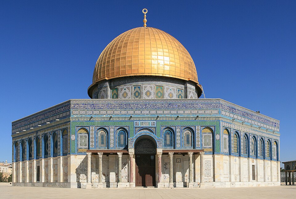
The Old City of Jerusalem and its Walls form a separate UNESCO property proposed by Jordan, rather than an item to add to Palestine’s country-list total. The Old City lies in occupied East Jerusalem and contains places sacred to Jews, Christians and Muslims. The Dome of the Rock is a shrine on the Haram al-Sharif/Temple Mount; it is distinct from the Al-Aqsa congregational mosque. The Church of the Holy Sepulchre is associated with Christian traditions of Jesus’s crucifixion and burial. Heritage pins locate places for learning and do not confirm a building’s present condition, opening or safe access.
People & Society of Palestine
Cities, villages, refugee communities and a worldwide diaspora sustain diverse Palestinian identities.
- Do all Palestinians live in the West Bank and Gaza?
- No. There are Palestinian citizens of Israel and large diaspora communities across the Middle East and elsewhere, alongside residents of the territories.
- Does Palestinian identity imply a single religion?
- No. Palestinian communities include Muslims, Christians, secular people and other traditions. Religion, national identity, citizenship and residency are distinct.
- Is a UNRWA refugee total the same as the Palestinian population?
- No. Refugee registration, territorial residency and worldwide Palestinian population measure different groups. Their totals should not be used interchangeably.
More about Palestine: people & society
Palestinians include Muslim and Christian communities, secular people and other traditions, with varied urban, village and Bedouin family histories. The small Samaritan community around Mount Gerizim has its own ancient religious tradition and distinct identity. Palestinian citizens of Israel and Palestinians abroad also belong to the wider account of Palestinian life, while their places of residence fall outside this guide’s map of the West Bank and Gaza. National identity, faith, citizenship and residency are different things.
Displacement in 1948, in 1967 and during later conflicts has shaped family histories across several generations. Refugee camps are also long-established communities, and being a registered refugee does not describe every Palestinian’s circumstances. The diaspora includes communities across the Middle East, the Americas, Europe and elsewhere. Education, literature, craft, sport and professional work connect people across borders. Population estimates must distinguish residents of the territories, refugees registered with UNRWA and Palestinians worldwide; those are different populations.