Facts about Namibia
Namibia runs from the fog-bound Atlantic coast to the Kalahari and the river wetlands of the northeast. Red dunes, granite mountains and a vast salt pan make its landscapes distinctive, but its towns, languages and community histories are equally varied. Windhoek is the inland capital; independence from South Africa came on 21 March 1990.
- Capital
- Windhoek
- Population
- 3,022,401 (2023 census)
- Area
- 824,292 km²
- Official language
- English
- Currency
- Namibian dollar (NAD)
- Regions
- 14
Namibia · 0 of 20 rounds passed
Two timed rounds per topic, 20 seconds a question
The Namib Desert follows the coast, cooled by the Benguela Current. The central highlands hold Windhoek, while the Kalahari Basin extends across the east. In the far northeast, the narrow extension commonly called the Caprivi Strip reaches towards the Zambezi. Namibia borders Angola, Zambia, Botswana and South Africa.
Water connects these regions to a wider southern Africa. The Kunene rises in Angola and reaches the Atlantic along the northern border. The Okavango begins in Angola, passes Namibia and spreads into Botswana’s inland delta. The Orange rises in Lesotho and flows through South Africa to the Atlantic; Namibia’s Fish River joins it. The Zambezi briefly touches Namibia before continuing through southern Africa to the Indian Ocean.
Geography of Namibia
A coastal desert, central highlands and rivers connecting four neighbours.
- Which countries border Namibia?
- Namibia borders Angola, Zambia, Botswana and South Africa. The Atlantic lies to the west, while its narrow northeastern extension reaches the Zambezi.
- Why is Namibia’s coast dry and foggy?
- The cold Benguela Current and regional atmospheric circulation limit rainfall. Coastal fog nevertheless supplies moisture to specialised plants and animals in the Namib.
- Does the Okavango reach the ocean?
- The Okavango flows from Angola past Namibia into Botswana’s inland delta. It spreads into wetlands and channels rather than reaching the sea.
More about Namibia: geography
Namibia lies on Africa’s southwestern Atlantic coast. The Namib is a coastal desert with dunes, gravel plains and rocky mountains; the Kalahari farther east is a sandy basin that also includes savanna and woodland. Much of the interior lies on a plateau. Brandberg contains Königstein, the country’s highest point at roughly 2,573 metres. The Fish River cuts a major canyon through the south.
The cold Benguela Current and the region’s atmospheric circulation help keep the coast dry. Fog nevertheless supplies moisture to desert organisms. Rainfall generally increases towards the northeast, where the Kavango and Zambezi regions contain floodplains and perennial rivers. Most rivers within the dry interior flow only after rain. A riverbed drawn on a map does not imply year-round surface water.
History of Namibia
Long community histories, colonial violence and the road to 1990.
- When did Namibia become independent?
- Namibia became independent on 21 March 1990 after a UN-supervised transition. Sam Nujoma became its first president; Walvis Bay was transferred in 1994.
- Who ruled Namibia before independence?
- German colonial rule was followed by South African administration after 1915. South Africa continued to rule after the United Nations terminated its mandate.
- What was the Herero and Nama genocide?
- German colonial forces targeted Herero and Nama peoples from 1904 to 1908 through warfare, expulsion, detention and forced labour, causing catastrophic loss of life.
More about Namibia: history
San, Nama, Damara, Herero, Ovambo, Kavango and other communities have histories that predate Namibia’s present borders. Trade, pastoral movement and farming linked the region to its neighbours. Germany declared a protectorate in 1884. German colonial forces carried out genocide against Herero and Nama peoples between 1904 and 1908, through warfare, expulsion, forced labour and detention.
South African forces defeated German rule in 1915. South Africa later administered the territory under a League of Nations mandate and continued its rule after the United Nations ended that mandate. Apartheid policies and the struggle led by SWAPO shaped the following decades. A UN-supervised transition brought independence on 21 March 1990, with Sam Nujoma as president. Walvis Bay remained under South African administration until its transfer to Namibia in 1994.
Language of Namibia
English in government, alongside a much broader multilingual society.
- What is Namibia’s official language?
- English is the sole official language. Most residents speak other home languages, including Oshiwambo varieties, Khoekhoegowab, Otjiherero, Afrikaans and Rukwangali.
- Is Oshiwambo one uniform language?
- Oshiwambo groups closely related languages and varieties, including Oshikwanyama and Oshindonga. It should not be treated as one identical form of speech everywhere.
- Which language do many Nama and Damara people share?
- Many Nama and Damara speakers use Khoekhoegowab, a Khoe language with click consonants. Shared language does not imply a single community identity or ancestry.
More about Namibia: language
English is Namibia’s sole official language. That administrative role does not make it the first language of most residents. Oshiwambo is a grouping of closely related languages, including Oshikwanyama and Oshindonga, rather than a single uniform variety. Other languages include Khoekhoegowab, Otjiherero, Rukwangali and Silozi. Afrikaans is used across communities, and German retains a historical presence.
Khoekhoegowab, spoken by many Nama and Damara people, belongs to the Khoe language family and uses click consonants. The older umbrella term Khoisan should not be presented as one established language family. Otjiherero and the Oshiwambo languages belong to the Bantu branch of Niger–Congo. Languages and community identities overlap in complex ways; language alone does not establish ancestry.
Culture of Namibia
Distinct traditions in dress, music, craft and contemporary urban life.
- What is otjize?
- Otjize is a mixture of butterfat and red ochre used on skin and hair among Himba communities. Its use has cultural and personal meanings.
- What is the Herero otjikaiva?
- The otjikaiva is a distinctive headdress whose shape evokes cattle horns. It accompanies long dresses influenced by Victorian clothing and adapted through Herero history.
- When is Namibia’s Heroes’ Day?
- Heroes’ Day falls on 26 August. It commemorates the beginning of the armed independence struggle in 1966, distinct from Independence Day in March.
More about Namibia: culture
Namibian cultural life reflects many communities and regions. Herero women’s long dresses draw on Victorian clothing but have acquired their own meanings, accompanied by the horn-shaped otjikaiva headdress. Among Himba communities, otjize combines butterfat and red ochre for use on skin and hair. These are living practices with local and personal variation, rather than costumes worn by every member of a group.
Basketry is associated with communities in Kavango and Zambezi, while music, dance and oral histories connect family and public life across the country. San knowledge traditions include detailed understanding of wildlife tracks and local plants. Contemporary artists and musicians work in Windhoek and other towns. Heroes’ Day, on 26 August, commemorates the beginning of the armed independence struggle in 1966.
Economy of Namibia
Minerals, fisheries, livestock and tourism across long distances.
- What is Namibia’s currency?
- Namibia uses the Namibian dollar, coded NAD and pegged at parity to the South African rand. The rand is also legal tender in Namibia.
- Which minerals does Namibia export?
- Diamonds and uranium are major mineral exports. Diamond recovery includes offshore operations, while uranium mines such as Rössing operate in the country’s western interior.
- Why is Walvis Bay economically important?
- Walvis Bay is a major port and fisheries centre. Road corridors also connect its Atlantic shipping facilities with Namibia’s interior and neighbouring landlocked countries.
More about Namibia: economy
Diamonds and uranium are major mineral exports. Diamonds are recovered both on land and offshore; uranium mines include Rössing in the Erongo Region. Namdeb is a partnership between Namibia’s government and De Beers. The Benguela system supports productive fisheries, while Walvis Bay serves as a port and transport gateway for Namibia and inland neighbours.
Livestock farming uses extensive dry rangelands, with crop cultivation more important in the wetter north. Tourism supports guiding, accommodation and businesses around desert and wildlife destinations. Long distances, limited water and uneven access to jobs and services shape economic opportunities. The Namibian dollar is pegged at parity to the South African rand, which is also legal tender in Namibia; the two currencies are not interchangeable everywhere outside the country.
Politics of Namibia
A constitutional republic with fourteen regions and two parliamentary chambers.
- How many regions does Namibia have?
- Namibia has fourteen administrative regions. Kavango East and Kavango West became separate regions in 2013, and Caprivi Region was renamed Zambezi.
- What are the chambers of Namibia’s Parliament?
- The National Assembly and National Council form Parliament. Assembly members are elected nationally, while regional councils select representatives for the National Council.
- Who was Namibia’s first woman president?
- Netumbo Nandi-Ndaitwah took office on 21 March 2025 as Namibia’s first woman president, following the election held in November 2024.
More about Namibia: politics
Namibia is a constitutional republic with an elected president and a prime minister. Parliament consists of the National Assembly and the National Council. The Assembly is elected nationally, while regional councils elect members to the National Council. The country has fourteen administrative regions, including Kavango East and Kavango West, created when the former Kavango Region was divided in 2013.
SWAPO has held the presidency since independence. Netumbo Nandi-Ndaitwah took office on 21 March 2025 as Namibia’s first woman president. The Constitution protects fundamental rights and, in Article 95(l), includes environmental protection among its principles of state policy. Land ownership, inequality, employment and the use of resource income remain significant political questions.
Nature & Wildlife of Namibia
Fog-fed desert life, Etosha’s waterholes and community conservancies.
- What is special about Welwitschia?
- Welwitschia grows two persistent foliage leaves that split and weather as it ages. It occurs in the Namib Desert of both Namibia and Angola.
- What are communal conservancies?
- Registered communal conservancies connect local institutions with wildlife management rights and responsibilities. They can link conservation with tourism and other community livelihoods.
- Is Etosha Pan always a lake?
- Etosha Pan is a large saline depression that is usually dry. Rain can produce shallow water, while nearby waterholes sustain wildlife through dry periods.
More about Namibia: nature & wildlife
Etosha National Park surrounds a large saline pan that can hold shallow water after good rains. Its waterholes attract animals including elephants, lions, giraffes and rhinos. In the northwest, desert-adapted elephants and black rhinos use arid landscapes and river corridors. Namibia is an important stronghold for cheetahs, including animals living beyond national parks.
Welwitschia mirabilis grows two persistent foliage leaves that become split and weathered over its long life. It occurs in the Namib of both Namibia and Angola. Cape Cross supports large Cape fur seal colonies, while offshore upwelling sustains marine food webs. Communal conservancies give registered communities rights and responsibilities in wildlife management, linking conservation to local institutions and livelihoods.
Food & Cuisine of Namibia
Mahangu, grilled kapana, sour milk and food shaped by place.
- What is mahangu?
- Mahangu is pearl millet, an important northern crop. It can be prepared as thick porridge and used in fermented grain drinks such as oshikundu.
- What is kapana?
- Kapana is grilled meat sold as street food, especially familiar in Windhoek. Vendors serve portions with seasonings and accompaniments that vary by place.
- Are omaere and oshikundu the same drink?
- Omaere is a fermented milk product, whereas oshikundu is made from grain, typically mahangu. Their ingredients and cultural associations differ even when served in similar settings.
More about Namibia: food & cuisine
Mahangu is pearl millet, an important crop in northern Namibia. It can be made into thick porridge, often called oshifima, and used in oshikundu, a fermented grain drink. Omaere is a fermented milk product associated especially with Herero food traditions. Mopane caterpillars, sometimes called mopane worms, are eaten in parts of the country and the wider region.
Kapana is grilled meat sold as street food, particularly familiar in Windhoek. Biltong is cured, dried meat, while potjiekos is slow-cooked in an iron pot over a fire. Fish and seafood feature along the coast. German-influenced baking and lager brewing form another part of a varied food landscape. No single dish describes the everyday meals of every Namibian household.
Landmarks of Namibia
The Namib Sand Sea, rock engravings and the landscapes beyond.
- What are Namibia’s World Heritage properties?
- Namibia has two inscribed properties: Twyfelfontein or /Ui-//aes, known for rock engravings, and the Namib Sand Sea, which includes the Sossusvlei dune landscape.
- What makes Deadvlei distinctive?
- Deadvlei combines pale clay, dark dead camel thorn trees and surrounding orange dunes. It lies near Sossusvlei within the Namib Sand Sea landscape.
- What is Kolmanskop?
- Kolmanskop is an abandoned diamond-mining settlement near Lüderitz. Desert sand has entered its buildings, making its industrial and colonial history visible in a striking landscape.
More about Namibia: landmarks
The dunes around Sossusvlei and the pale clay of nearby Deadvlei lie within the UNESCO-listed Namib Sand Sea. Deadvlei’s dark dead camel thorn trees stand against bright sand. Twyfelfontein, also called /Ui-//aes, is Namibia’s other World Heritage property, inscribed for its rock engravings and associated cultural landscape. Neither place should be confused with a ruin of a built city.
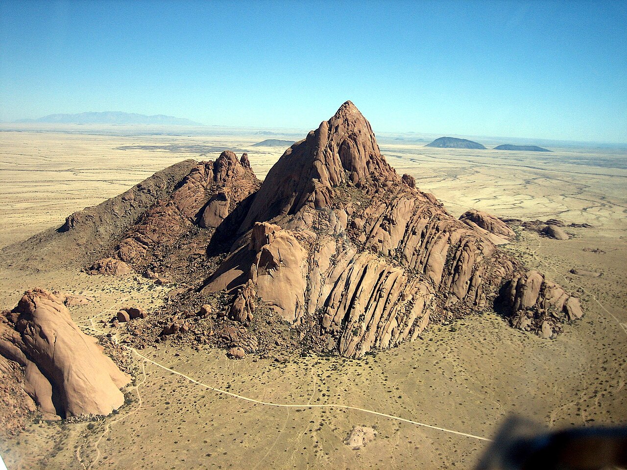
Fish River Canyon cuts through southern Namibia, while Spitzkoppe’s granite peaks rise from the western interior. Etosha and Waterberg offer contrasting wildlife landscapes. Swakopmund retains German-era buildings; near Lüderitz, Kolmanskop is a former diamond settlement partly overtaken by sand. Windhoek’s Christuskirche and Heroes’ Acre reflect different periods of the country’s history.
People & Society of Namibia
A small population spread unevenly across a large country.
- How many people live in Namibia?
- The 2023 census counted 3,022,401 residents. This dated census count differs from later population estimates and should always be presented with its reference year.
- Where is Namibia’s population concentrated?
- Settlement is concentrated in northern areas and urban centres such as Windhoek. Low national density masks considerable differences between regions, towns and rural districts.
- What is Frankie Fredericks known for?
- Frankie Fredericks is a Namibian sprinter who won four Olympic silver medals across the 100 metres and 200 metres at the 1992 and 1996 Games.
More about Namibia: people & society
Namibia’s 2023 census counted 3,022,401 residents. The country has low average population density, but settlement is concentrated in particular northern areas and urban centres such as Windhoek. A census count should be distinguished from a later population estimate. Internal migration connects rural households with jobs, education and relatives in towns.
Ovambo, Kavango, Herero, Nama, Damara, San, Baster and other identities carry varied histories and languages. Rehoboth is an important historic centre for Baster communities. Public figures include liberation leaders Sam Nujoma and Hendrik Witbooi, sprinter Frankie Fredericks and 1992 Miss Universe winner Michelle McLean. Communities and individuals should not be reduced to a single appearance, occupation or supposed ancestry.