Facts about Mali
Explore Mali from Bamako and the Niger’s inland delta to Djenné, Timbuktu, Gao and the Sahara. Twelve city and town pins, ten heritage and landscape locations and ten illustrated topics connect geography with histories, music, languages and everyday life.
- Capital
- Bamako
- Area
- About 1.24 million km²
- Currency
- West African CFA franc (XOF)
- Official languages
- National languages (2023 constitution)
- Working language
- French (2023 constitution)
- National day
- 22 September
Mali · 0 of 20 rounds passed
Two timed rounds per topic, 20 seconds a question
Bamako lies in the southwest on the Niger River. Kayes and Kita connect the west with the Senegal River basin, while Sikasso and Bougouni orient the southern farming country. Ségou, San and Mopti lead toward the inland delta. These are settlement locations, separate from Mali’s changing administrative divisions.
Djenné and Bandiagara introduce earthen urban heritage and the escarpment landscape. Farther north, Timbuktu recalls Saharan trade and manuscript learning; Gao sits beside the Niger’s eastern reach, and Kidal lies in the northeast near the Adrar des Ifoghas. Learning about these places does not imply that travel is safe or access is available.
Geography of Mali
The Niger’s inland delta, southern savannas and a Saharan north.
- Does Mali have a coastline?
- No. Mali is landlocked and relies on routes through other countries to reach seaports.
- What is the Inner Niger Delta?
- A seasonal network of channels, lakes and floodplains in central Mali, rather than a river mouth on the coast.
- Are the Niger River and the country Niger the same thing?
- No. The river crosses several countries, including Mali and neighbouring Niger.
More about Mali: geography
Mali is a landlocked country in West Africa, covering about 1.24 million square kilometres. It borders Mauritania, Algeria, Niger, Burkina Faso, Côte d’Ivoire, Guinea and Senegal. Bamako, the capital, stands on the Niger River in the southwest. The wetter southern savannas support farming, while the Sahel forms a drier belt farther north and the Sahara occupies much of the northern territory.
The Niger rises in Guinea, flows northeast through Bamako and Ségou, and spreads into the Inner Niger Delta around Mopti and Lake Débo. Seasonal floods create channels, lakes and grazing lands before the river turns toward Gao and neighbouring Niger. This inland delta is distinct from the Niger’s coastal delta in Nigeria. In western Mali, the Bafing and Bakoy meet near Bafoulabé to form the Senegal River.
History of Mali
Sahelian empires, manuscript learning and independence in 1960.
- Who is associated with founding the Mali Empire?
- Sundiata Keita, in the thirteenth century; his story is also preserved in an important oral epic.
- Why is Timbuktu associated with learning?
- Its scholars, mosques and manuscript libraries connected Islamic learning with Saharan trade.
- What does Mali commemorate on 22 September?
- The proclamation of the Republic of Mali in 1960, following the breakup of the Mali Federation.
More about Mali: history
The empires of Ghana, Mali and Songhai connected different parts of the western Sahel through trade and political power. They did not share the borders of today’s countries; the medieval Ghana Empire was not the modern Republic of Ghana. Sundiata Keita is associated with the foundation of the Mali Empire in the thirteenth century. Mansa Musa’s pilgrimage to Mecca in 1324–1325 became famous for its display of wealth, but a precise ranking of his fortune against modern individuals cannot be established.
Timbuktu and Djenné developed as centres of commerce and Islamic learning, while Gao became a major Songhai capital. Manuscripts preserve scholarship in religion, law, astronomy and other fields. French conquest incorporated much of today’s Mali into French Sudan. After a brief federation with Senegal, the Republic of Mali was proclaimed on 22 September 1960 under Modibo Keïta. Later military coups, democratic movements, rebellions and conflict form further chapters of its history.
Mali’s languages
Bamanankan, Fulfulde, Songhay and Tamasheq within a multilingual country.
- Is French still Mali’s sole official language?
- No. The 2023 constitution makes national languages official and calls French a working language.
- What is Bamanankan?
- The language commonly called Bambara, a Mande language widely used in Mali.
- What is N’Ko?
- A writing system created in 1949 for Manding languages, including Bambara.
More about Mali: language
Article 31 of Mali’s 2023 constitution gives official status to national languages and designates French as a working language. Bamanankan, commonly called Bambara, is widely used for communication across communities, especially in the south. It belongs to the Mande language group. Fulfulde, Songhay languages, Tamasheq, Soninké and other languages carry their own oral traditions, education and everyday conversations. No single language describes every Malian household.
Writing traditions include Latin-based alphabets, Arabic and adapted Arabic writing, the N’Ko script used for Manding languages, and Tifinagh associated with Tuareg languages. N’Ko was created by Solomana Kanté in 1949; it is not a form of Arabic. The classroom photograph depicts Tireli in 2008, rather than establishing which language any pupil speaks. Worldly links to its existing general French course; it does not currently offer a dedicated Bambara course.
Culture of Mali
Jeli storytelling, regional music, cloth and photography.
- What does a jeli do?
- Performs music and oral history, often preserving genealogies, praise and social memory.
- How do the kora and balafon differ?
- The kora has strings; the balafon has wooden keys struck with beaters.
- What did Seydou Keïta become known for?
- Studio portraits of people in Bamako, especially from the mid-twentieth century.
More about Mali: culture
Jeliw, often called griots in English, preserve oral histories through praise, performance and accounts of family and political life. The kora is a stringed harp-lute, the ngoni a plucked lute, and the balafon a wooden-key instrument related to the xylophone. These traditions extend across West African borders. Ali Farka Touré’s guitar music, Oumou Sangaré’s Wassoulou singing and Toumani Diabaté’s kora playing illustrate different strands of Malian musical life.
Tuareg guitar groups including Tinariwen have reached international audiences, but “desert blues” is a broad international label rather than a description of every local genre. Bògòlanfini cloth uses processes involving plant dyes and fermented mud. Photographers Seydou Keïta and Malick Sidibé documented portraits, fashion and social life in Bamako. The pictured Dogon mask performance represents a particular tradition; ceremonial practices and permissions vary between communities.
Economy of Mali
Gold, cotton, river farming and regional trading networks.
- Which two exports are especially associated with Mali?
- Gold and cotton.
- Which currency does Mali use?
- The West African CFA franc, currency code XOF.
- Why do river levels matter to the economy?
- They influence irrigation, fisheries, seasonal grazing and transport in river communities.
More about Mali: economy
Gold is a major export, and cotton is an important agricultural cash crop. Industrial mines and smaller artisanal operations have different working conditions and environmental effects. Farmers also grow millet, sorghum, maize and rice for domestic use. Irrigated agriculture around the Niger River complements rain-fed fields; livestock keeping, fishing, craftwork and markets support many households. Export earnings and the work people do are different measures of an economy.
Mali uses the West African CFA franc, with currency code XOF, issued by the BCEAO and shared with other members of the West African monetary union. Being landlocked makes transport links to coastal neighbours important. Rainfall, flood levels, world commodity prices, electricity supply and insecurity affect livelihoods. Cotton preparation near Mpessoba is shown in the photograph; it is one part of a wider rural economy, rather than a picture of gold production.
Politics of Mali
A military-led transition, regional ties and changing institutions.
- Which events began the present military-led transition?
- Coups in August 2020 and May 2021 interrupted civilian government.
- What was MINUSMA?
- A United Nations peacekeeping mission in Mali whose withdrawal was completed in December 2023.
- Which countries formed the Alliance of Sahel States?
- Mali, Burkina Faso and Niger.
More about Mali: politics
Military coups in August 2020 and May 2021 interrupted civilian government. Assimi Goïta became transition president in 2021. A new constitution was promulgated in July 2023, but a constitutional description must be distinguished from how a military-led transition operates. The United Nations peacekeeping mission MINUSMA completed its withdrawal in December 2023. Rebellions, armed-group violence and displacement have affected northern, central and other parts of Mali; conflict cannot be reduced to one community or one desert region.
Mali, Burkina Faso and Niger established the Alliance of Sahel States in 2023 and a confederation in 2024. Their withdrawal from ECOWAS took effect in January 2025; this is distinct from membership of the West African monetary union. Institutions and security conditions continue to change. Official UK advice, checked on 26 October 2026, advises against all travel to Mali. The guide’s pins introduce places for learning and do not establish safe routes, opening hours or permission to visit.
Nature & Wildlife of Mali
Floodplain birds, fisheries and the elephants of the Gourma.
- Why does the Inner Niger Delta change shape?
- Floodwater rises and falls with seasonal river flows and rainfall across the basin.
- Are Mali’s “desert elephants” a separate species?
- No. The name describes African elephants living in a dry environment.
- Why do the Gourma elephants move over long distances?
- To reach seasonal water and feeding areas across their range.
More about Mali: nature & wildlife
The Inner Niger Delta is a large seasonal wetland supporting fish, grazing and waterbirds, including migrants arriving from Europe. Its flood pulse depends on rainfall and river flows across a wider basin, so its extent changes between seasons and years. Lake Débo, pictured from a satellite, is part of this wetland system. River habitats contrast with southern woodland and savanna and the much drier environments farther north.
The Gourma landscape supports a population of elephants known for long seasonal movements between water and grazing resources. They are African elephants adapted to a dry landscape, rather than a separate species of “desert elephant”. Their survival depends on connected habitats, community conservation and protection from poaching. Drought, armed conflict and competing land uses create pressures for wildlife and people alike. The Boucle du Baoulé landscape in western Mali preserves another savanna and river environment.
Food & Cuisine of Mali
Millet, sorghum, rice, sauces and the Niger’s fisheries.
- What is tô?
- A firm preparation made from cereal flour and water, commonly served with sauces.
- Which river helps support Mali’s fisheries?
- The Niger River and its connected channels, lakes and floodplains.
- Is Malian cuisine the same in every region?
- No. Crops, livelihoods, household preferences and cross-border traditions all contribute to variety.
More about Mali: food & cuisine
Malian cooking varies with region, household and season. Millet and sorghum are important grains, while rice is central to many river and irrigated farming areas. Tô is a firm cereal preparation served with sauces; ingredients differ, and it is not one fixed national recipe. Groundnut sauces, leafy vegetables and okra accompany staples in many meals. Fonio, a small-grained cereal, also belongs to regional food traditions.
Fresh, smoked and dried fish connect meals with the Niger’s fisheries. Meat, dairy products and different ways of preparing grain reflect pastoral and farming histories across the country. Sweetened tea is associated with hospitality and social time in many settings. Food traditions extend into neighbouring countries, so a familiar dish need not have a single national origin. The photograph shows a food sales stand in Bamako, rather than an identified plate of a specific recipe.
Landmarks of Mali
Earthen Djenné, Timbuktu’s libraries, Bandiagara and Gao.
- How many inscribed World Heritage properties does Mali have?
- Four: Timbuktu, the Old Towns of Djenné, the Cliff of Bandiagara and the Tomb of Askia.
- What material is associated with Djenné’s Great Mosque?
- Earth, maintained through recurring replastering and repairs.
- Where is the Tomb of Askia?
- In Gao, in eastern Mali.
More about Mali: landmarks
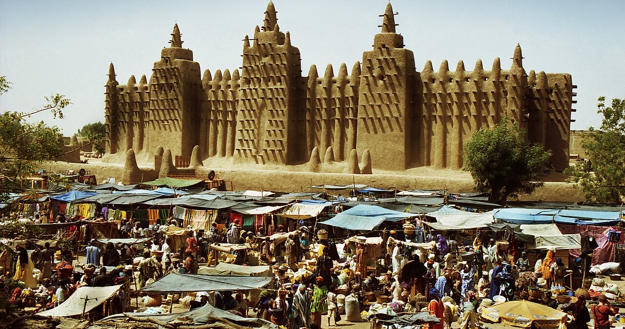
The Old Towns of Djenné, Timbuktu, the Cliff of Bandiagara and the Tomb of Askia are Mali’s four inscribed UNESCO World Heritage properties. Djenné’s Great Mosque is a monumental earthen building; the present mosque dates from the early twentieth century and stands within a much older townscape. Maintaining earthen buildings requires recurring work and local knowledge. The annual replastering of the mosque is both building care and a community event.
Timbuktu’s mosques and manuscript collections connect its urban history with Saharan trade and Islamic scholarship. The Bandiagara escarpment is a lived cultural landscape with villages, farming and different historical layers, rather than an uninhabited monument. At Gao, the Tomb of Askia recalls the Songhai ruler Askia Muhammad and fifteenth-century imperial power. Damage, restoration and changing security have affected heritage sites; UNESCO recognition does not imply that access is currently possible.
People & Society of Mali
Urban life, river communities and identities that cross borders.
- Does a community name tell you someone’s occupation?
- No. Labels may have historical associations, but individuals have varied livelihoods and identities.
- How are Bamako and rural Mali connected?
- Through migration, family ties, markets, education and the movement of goods and money.
- Do Mali’s cultural and language networks stop at its borders?
- No. Many connect families and communities across neighbouring West African countries.
More about Mali: people & society
Bambara, Fulani, Soninké, Songhay, Tuareg, Dogon, Bozo, Senufo and other communities contribute to Mali’s social life. These broad names contain internal differences and overlapping identities. Language, occupation, religion, place and family history do not line up in one simple pattern. Many Malians are Muslim, while Christian communities and local religious traditions also form part of the country. A community label does not establish a person’s beliefs or political views.
Bamako draws residents from across Mali, linking markets, universities, cultural work and families with rural areas and the diaspora. River trade, fishing, farming and pastoral movement create other networks between towns and countryside. Conflict has displaced people within Mali and across borders, adding pressures to households and host communities. The people photographed in a street scene or classroom are individuals in a particular place and time, rather than representatives of a single national way of life.