Facts about Ethiopia
Explore Ethiopia through Lalibela’s rock-hewn churches, Harar’s walled streets, coffee-growing highlands and the Rift Valley. Discover ancient kingdoms, living cultural landscapes and mountain wildlife alongside the languages and everyday life of a diverse country in the Horn of Africa.
- Capital
- Addis Ababa
- Currency
- Ethiopian birr (ETB)
- Regional states
- 12
- City administrations
- Addis Ababa and Dire Dawa
- UNESCO World Heritage (Oct 2026)
- 12 properties
- Coastline
- Landlocked
Ethiopia · 0 of 20 rounds passed
Two timed rounds per topic, 20 seconds a question
Addis Ababa stands in the central highlands and hosts the African Union’s headquarters. To the north lie Lake Tana, Gondar, Lalibela and Aksum; to the east are Afar’s lowlands, Dire Dawa and Harar. The southern Rift leads towards Hawassa, the lakes beside Arba Minch and the Konso landscape. Southwestern forests connect coffee-growing areas with a different climate and ecology.
Use the maps to learn twelve regional states, two city administrations and a separately marked contested area, then place twenty-four cities, eight waters and sixteen sights. The source preserves recent southern regional changes. Heritage and landscape pins support geographical learning; they do not establish current opening or safe access.
Geography of Ethiopia
High plateaus, the Rift Valley and rivers that flow towards different basins.
- Is Ethiopia landlocked?
- Yes. Ethiopia has no coastline. Eritrea, Djibouti and Somalia separate much of its northern and eastern territory from the Red Sea and Gulf of Aden.
- Where does the Blue Nile leave Lake Tana?
- Near Bahir Dar in northwestern Ethiopia. Known as the Abay in Ethiopia, the river later joins the White Nile at Khartoum in Sudan.
- Do all Ethiopian rivers flow to the Nile?
- No. The Awash ends in an inland basin, and the Omo flows into Lake Turkana. Other rivers drain towards Somalia.
More about Ethiopia: geography
Ethiopia lies in the Horn of Africa, bordered by Eritrea, Djibouti, Somalia, Kenya, South Sudan and Sudan. The Main Ethiopian Rift separates highland blocks and continues northeast towards Afar. Elevation changes the climate sharply: Addis Ababa stands in cool uplands, while parts of the Danakil Depression lie below sea level. Ras Dashen in the Simien Mountains is the highest peak.
Lake Tana drains into the Abay, or Blue Nile, which continues into Sudan. The Awash flows towards the Afar lowlands and the Lake Abbe basin rather than reaching the sea. The Omo feeds Lake Turkana, shared with Kenya. Ethiopia has been landlocked since Eritrean independence in 1993. Its overseas trade depends heavily on routes through Djibouti.
History of Ethiopia
Aksum, medieval kingdoms, Adwa, Italian occupation and revolution.
- Why does the Battle of Adwa matter?
- Ethiopia defeated an Italian invasion in 1896. The victory became an influential example of African resistance to colonial conquest.
- Was Ethiopia ever occupied by Italy?
- Yes, from 1936 to 1941. Adwa’s earlier victory and the later occupation belong to different periods.
- What was the Derg?
- The military government that ruled from 1974 to 1991 after the overthrow of Emperor Haile Selassie.
More about Ethiopia: history
The kingdom of Aksum linked the northern highlands with Red Sea trade. Its monumental stelae, inscriptions and coinage preserve evidence of a powerful ancient state; Christianity became a royal religion in the fourth century. Later centres included Lalibela and Gondar. Muslim sultanates, Oromo histories and southern kingdoms also shaped the territory that became modern Ethiopia.
Ethiopian forces defeated Italy at Adwa on 1 March 1896, defending the state’s independence during the colonial partition of Africa. Italy later occupied Ethiopia from 1936 to 1941. The monarchy ended with the overthrow of Haile Selassie in 1974, followed by Derg military rule until 1991. Eritrea became independent in 1993. The federal constitution came into force in 1995.
Languages of Ethiopia
Amharic, Afaan Oromo, Somali, Tigrinya, Afar and many other languages.
- Is Amharic Ethiopia’s only language?
- No. Ethiopia is multilingual. Amharic is named in the constitution as the federal working language, while many languages serve regional and everyday life.
- Do Amharic and Afaan Oromo use the same script?
- Usually no. Amharic uses the Ethiopic script; contemporary Afaan Oromo commonly uses the Latin-based Qubee alphabet.
- Which language lessons are linked here?
- Amharic, Somali and Tigrinya. They do not represent every language spoken in Ethiopia.
More about Ethiopia: language
Amharic and Tigrinya are Semitic languages written in forms of the Ethiopic script. Afaan Oromo, Somali and Afar belong to the Cushitic branch of the wider Afroasiatic family and commonly use Latin-based writing systems. Other languages include Sidama, Wolaytta, Gurage varieties, Harari, Nuer and Anuak. A regional label does not imply that everyone there speaks one language.
The constitution gives all Ethiopian languages equal state recognition and names Amharic as the federal working language; regional states choose their own working languages. Worldly links to existing Amharic, Somali and Tigrinya lessons. These are starting points within a much wider language landscape. Geʽez remains important in liturgy and manuscripts and is distinct from modern Amharic and Tigrinya.
Culture of Ethiopia
Coffee, music, religious festivals and community traditions.
- What is a jebena?
- A clay coffee pot used in Ethiopian and Eritrean coffee traditions. Ceremonies vary between households and communities.
- How many months are in the Ethiopian calendar?
- Thirteen: twelve months of thirty days and a final month of five days, or six in a leap year.
- What is Gada?
- An Oromo system of governance and social organisation transmitted through generations. UNESCO recognises it as intangible cultural heritage.
More about Ethiopia: culture
A coffee ceremony can bring roasting, grinding and brewing together in a social occasion, often using a clay jebena. Music includes the krar lyre, masenqo fiddle, regional vocal traditions and the jazz associated with musicians such as Mulatu Astatke. Eskista emphasises shoulder movement, but it is one dance tradition among many. Contemporary artists also work across languages and diaspora communities.
Timkat and Meskel belong to Ethiopian Orthodox Christian traditions. Muslim communities celebrate Islamic festivals, while Fichee-Chambalaalla marks the Sidama new year. The Oromo Gada system carries knowledge about governance and social responsibility. The Ethiopian calendar has twelve thirty-day months and a short thirteenth month. Calendars, festivals, faith and language overlap differently in each community.
Economy of Ethiopia
Coffee farming, transport, services and hydroelectric power.
- What is Ethiopia’s currency?
- The Ethiopian birr, abbreviated ETB. Exchange rates change, so the guide does not give a fixed conversion.
- Why is Djibouti important to Ethiopian trade?
- Its ports connect Ethiopia with overseas shipping, supported by road and rail links across the border.
- On which river is the Grand Ethiopian Renaissance Dam?
- The Blue Nile, known in Ethiopia as the Abay. Its main purpose is generating electricity.
More about Ethiopia: economy
Farming and livestock support many livelihoods. Coffee links highland growers and processors with international markets; cereals such as teff, maize, wheat and sorghum supply food markets. Horticulture, manufacturing and services provide other kinds of work. Addis Ababa connects aviation, finance, administration and trade, while road and rail routes to Djibouti serve the landlocked country.
The Ethiopian birr, ETB, is the national currency. Hydroelectric schemes include the Grand Ethiopian Renaissance Dam on the Blue Nile. Water management has implications for downstream Sudan and Egypt as well as Ethiopia. Economic reforms begun in 2024 changed foreign-exchange arrangements. Conflict, inflation, drought and unequal access to services continue to affect households, so growth figures alone give an incomplete picture.
Politics of Ethiopia
Federal institutions, twelve regional states and two city administrations.
- How many regions does Ethiopia have?
- Twelve regional states, alongside the separate city administrations of Addis Ababa and Dire Dawa. The map also preserves OCHA’s separately designated contested area.
- Why does the map contain fifteen learning areas?
- It preserves twelve regions, two city administrations and one contested reference area from the OCHA dataset. The contested area is not an additional regional state.
- Who heads Ethiopia’s government?
- The prime minister. The president is head of state under the federal constitutional system.
More about Ethiopia: politics
Ethiopia’s constitutional system is a federal parliamentary republic. The prime minister heads the government, while the president is head of state. The federal legislature comprises the House of Peoples’ Representatives and the House of Federation. The constitution connects regional self-government with the rights of nations, nationalities and peoples; actual political life also involves disputes over representation, power and territory.
There are twelve regional states and two city administrations, Addis Ababa and Dire Dawa. Sidama, South West Ethiopia, Central Ethiopia and South Ethiopia emerged through recent reorganisations of the former Southern Nations, Nationalities and Peoples’ Region. The OCHA reference map additionally marks a contested area separately; it is not a thirteenth regional state. The northern war began in 2020, and a cessation-of-hostilities agreement was signed in Pretoria in November 2022. Later conflict and displacement mean that this agreement should not be read as proof of present safety.
Nature & Wildlife of Ethiopia
Mountain grasslands, cloud forests, Rift lakes and dry lowlands.
- Where are Walia ibex found?
- In the Simien Mountains of northern Ethiopia. Their very limited range makes habitat protection important.
- Which animals are associated with Bale?
- The Ethiopian wolf and mountain nyala are notable examples, alongside many birds and other species across highland and forest habitats.
- Are Bale and Simien the same mountain range?
- No. Simien lies in the northern highlands; Bale lies southeast of the main Rift in Oromia.
More about Ethiopia: nature & wildlife
The Simien Mountains have steep escarpments and high grasslands associated with Walia ibex and geladas. Farther southeast, Bale combines the Sanetti Plateau’s Afroalpine habitats with the Harenna Forest. Ethiopian wolves depend on highland ecosystems, while mountain nyala are associated with the Bale area. Simien and Bale are both natural World Heritage properties.
Rift lakes provide habitats for fish and waterbirds. Southwestern forests include areas important to wild Arabica coffee, while the Afar lowlands contain salt landscapes and active volcanic systems. Habitat loss, livestock pressure, disease and changing climate affect conservation in different ways. Protected status does not establish present access, wildlife abundance or safe conditions for a visit.
Food & Cuisine of Ethiopia
Injera, grain and pulse dishes, regional staples and coffee.
- What is injera made from?
- Traditionally fermented teff batter, although other grains and mixtures are also used. It is a soft, sour flatbread.
- What is shiro?
- A preparation using ground pulses, often chickpeas or other legumes, with seasonings that vary by recipe.
- What is enset used for?
- Enset is a major food plant in parts of southern Ethiopia. Its processed tissues provide foods including fermented kocho.
More about Ethiopia: food & cuisine
Injera is a fermented flatbread often made with teff, sometimes mixed with other grains. Pieces are used to scoop stews, vegetables and pulses. Wat, also written wot, covers a family of stews: doro wat uses chicken, while misir wat uses lentils. Berbere is a spice mixture with recipes that vary, and shiro commonly uses ground pulses.
Regional food traditions extend beyond an injera platter. Enset supports important food systems in parts of the south; kocho is one of its fermented products. Fish is eaten around lakes, including Tana. Orthodox fasting traditions contribute to a wide range of plant-based dishes, while Muslim dietary practices and household preferences also shape meals. Coffee has both agricultural and social importance. Food descriptions introduce culinary knowledge without assuming equal access to ingredients.
Landmarks of Ethiopia
Rock-hewn churches, Islamic urban heritage, working landscapes and early human sites.
- How many World Heritage properties does Ethiopia have?
- Twelve, as checked in October 2026: ten cultural and two natural properties. A property can contain more than one component.
- Are all eleven Lalibela churches separate UNESCO inscriptions?
- No. They form one World Heritage property, the Rock-Hewn Churches of Lalibela.
- What do Gedeo and Konso add to the heritage map?
- They recognise landscapes shaped by living farming and settlement traditions, including Gedeo agroforestry and Konso terraces.
More about Ethiopia: landmarks
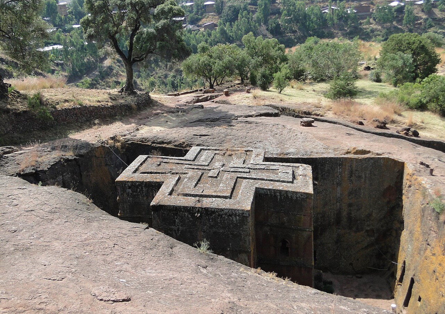
Lalibela’s eleven medieval churches were cut into rock, with Saint George’s cross-shaped church among the best known. Aksum preserves stelae, tombs and archaeological remains of the ancient kingdom. Gondar’s Fasil Ghebbi connects royal buildings with the city’s later history. Harar Jugol’s walls, houses and mosques record a different urban tradition shaped by Islamic scholarship and trade.
Ethiopia has twelve World Heritage properties as checked in October 2026. They include Konso’s terraced cultural landscape, Gedeo’s agroforestry landscape, Tiya’s stelae, the Lower Awash and Lower Omo fossil landscapes, and Melka Kunture and Balchit, inscribed in 2024. Bale and Simien supply the two natural properties. Lake Tana’s monasteries and Sof Omar’s caves are on the Tentative List; they should not be counted as additional inscriptions.
People & Society of Ethiopia
Many languages, faiths and livelihoods, connected across regions and borders.
- Does one language or religion define every Ethiopian?
- No. Ethiopian identities include many languages, faiths, regional ties and family histories.
- Are regional borders maps of ethnicity?
- No. Regions contain mixed communities, and people live and work across boundaries. Reference maps cannot define an individual’s identity.
- Why does displacement matter when describing society?
- It changes where people live and their access to homes, schools, livelihoods and services. Older descriptions can miss those changes.
More about Ethiopia: people & society
Ethiopia includes Oromo, Amhara, Somali, Tigrayan, Sidama, Afar, Gurage, Wolaytta and many other communities. Language, religion, regional ties and personal history combine in different ways. Ethiopian Orthodox, Muslim, Protestant and other religious communities contribute to national life. Community names are broad labels and cannot describe every person’s beliefs, occupation or political views.
Urban centres connect schools, workplaces and markets with rural households. Farming and pastoral livelihoods vary with rainfall, altitude and access to land, while diaspora communities maintain family and cultural links across borders. War and other crises have displaced people within Ethiopia and into neighbouring countries. Historical photographs and regional boundaries do not show where every community lives today or the conditions displaced families face.