Facts about Cyprus
Explore Cyprus from Paphos and the Troodos villages to Nicosia, Kyrenia and the long Karpas Peninsula. Explore six districts, settlements and waters, then discover the island’s archaeology, mountain castles, shared foods and distinct communities through ten illustrated topics, twenty sights and Greek and Turkish lessons.
- Location
- Eastern Mediterranean
- Capital
- Nicosia (Lefkosia / Lefkoşa)
- Republic’s official languages
- Greek and Turkish
- Currencies in use
- Euro; Turkish lira in the north
- Highest point
- Mount Olympus, 1,952 m
- Republic’s EU accession
- 1 May 2004
Cyprus · 0 of 20 rounds passed
Two timed rounds per topic, 20 seconds a question
Cyprus lies in the eastern Mediterranean, south of Türkiye and west of Syria and Lebanon. The Troodos Mountains occupy the centre and southwest, the Kyrenia range follows the northern coast, and the Mesaoria plain lies between them. Nicosia is inland; Limassol, Larnaca and Paphos face the southern and western coasts. Kyrenia, also called Girne, and Famagusta, also called Gazimağusa, are in the Turkish Cypriot-administered north.
This guide explores the whole island. The internationally recognised Republic of Cyprus does not exercise effective control in the north, where the self-declared state is recognised only by Türkiye. A UN buffer zone separates the sides, including within Nicosia. Akrotiri and Dhekelia are UK Sovereign Base Areas. The districts map follows Republic of Cyprus boundaries across the island. It does not show effective control, present access or crossing routes.
Geography of Cyprus
Mountains, coastlines and settlement centres across the whole island.
- Where is Cyprus?
- In the eastern Mediterranean, south of Türkiye and west of Syria and Lebanon. It is a separate island state, not part of Greece.
- What is the highest point?
- Mount Olympus in the Troodos range, at 1,952 metres. It is different from Mount Olympus in Greece.
- Does the map cover northern Cyprus?
- Yes. The city and sights maps cover the whole physical island, including northern Cyprus and the UK Sovereign Base Areas, without drawing administrative borders.
More about Cyprus: geography
Cyprus is the Mediterranean’s third-largest island after Sicily and Sardinia. It lies south of Türkiye and west of the Levant, much closer to those coasts than to mainland Greece. The Troodos massif rises in the centre and southwest, reaching 1,952 metres at Mount Olympus. The narrower Kyrenia range, also known as Pentadaktylos or Beşparmak, runs along the north. Between the ranges, the Mesaoria plain holds farmland and the divided capital, Nicosia.
The coast changes from Akamas in the northwest to Paphos in the southwest, Limassol on the south coast and Larnaca farther east. Cape Greco lies near the southeastern resorts of Ayia Napa and Protaras. In the north, Kyrenia faces Türkiye across the sea, while Famagusta stands on the eastern shore. The long Karpas, or Karpaz, Peninsula extends northeast beyond the town of Rizokarpaso, also called Dipkarpaz.
The Republic’s six districts, the northern administration’s districts, the UN buffer zone and the UK Sovereign Base Areas describe different administrative or political arrangements. The districts map shows the Republic’s districts, not the other arrangements. The city map uses sixteen settlement centres across the island, with a single Nicosia pin representing the capital’s location. Its physical coastline includes northern Cyprus and the base areas without suggesting that one government administers the entire island.
History of Cyprus
From Neolithic houses and copper trade to independence and division.
- When did Cyprus become independent?
- In 1960, after British rule. Britain retained the Sovereign Base Areas of Akrotiri and Dhekelia.
- What happened in 1974?
- A coup backed by Greece’s military junta sought union with Greece, followed by Türkiye’s invasion. Conflict and displacement consolidated the division that continues today.
- What is Choirokoitia?
- A Neolithic settlement with the remains of round houses, separately inscribed as a UNESCO World Heritage property.
More about Cyprus: history
People settled Cyprus long before its classical city-kingdoms. Choirokoitia preserves a Neolithic settlement whose round buildings help explain an early farming community. Copper linked the island with Bronze Age trading networks; the Latin expression aes cyprium, metal of Cyprus, is part of the history of the English word copper. Greek-speaking and Phoenician communities later shared an island that came under Assyrian, Egyptian, Persian and Hellenistic powers before Roman rule.
Christian traditions connect Cyprus with the first-century journeys of Paul and Barnabas. Byzantine churches, Lusignan castles and Venetian walls reveal later periods. The Lusignan kingdom began in 1192, after Richard I’s conquest during the Third Crusade. Venice took control in 1489, and the Ottomans conquered the island in 1570–1571. Britain began administering Cyprus in 1878, annexed it in 1914 and made it a Crown colony in 1925.
The Republic of Cyprus became independent in 1960, with Greek Cypriot and Turkish Cypriot power-sharing provisions. Constitutional breakdown and intercommunal violence preceded the UN peacekeeping mission established in 1964. In July 1974 a coup backed by Greece’s military junta sought union with Greece; Türkiye invaded, and the ensuing conflict and displacement consolidated the island’s division. The northern declaration of a separate state followed in 1983. Independence, division and EU accession in 2004 are separate milestones.
Languages of Cyprus
Two official languages, local varieties and several names for the same places.
- Which languages are official?
- Greek and Turkish are the official languages of the Republic of Cyprus. English is widely used but does not have that status.
- Do the lessons teach Cypriot dialects?
- The linked lessons teach Modern Greek and Turkish, rather than dedicated Cypriot Greek or Cypriot Turkish courses.
- Are Girne and Kyrenia different towns?
- No. They are Turkish and commonly used English names for the same northern coastal town. Lefkosia and Lefkoşa similarly refer to Nicosia.
More about Cyprus: language
Greek and Turkish are the official languages of the Republic of Cyprus. Cypriot Greek and Cypriot Turkish have distinctive pronunciation and vocabulary, and everyday local speech differs from the standard forms used in many classrooms and publications. Greek predominates in the Republic-controlled area, while Turkish predominates in the north. English is widely used in tourism and business, influenced by both British rule and international connections; it is not one of the Republic’s two official languages.
The linked courses introduce Modern Greek and Turkish, rather than dedicated Cypriot dialect courses. Greek uses its own alphabet; modern Turkish uses a Latin-based alphabet. Yassas is a polite Greek greeting, and merhaba is a Turkish hello. Place names may have several forms: Lefkosia and Lefkoşa refer to Nicosia, while Girne is Kyrenia and Gazimağusa is Famagusta. Seeing two names does not mean there are two different towns.
Armenian and Cypriot Maronite Arabic also belong to the island’s linguistic heritage, alongside languages brought by newer residents. Ancient writing has a different history: the Cypriot syllabary was used for Greek and for the still poorly understood Eteocypriot language. It belongs to a wider Aegean and Cypriot writing tradition, but should not be described simply as the modern Greek alphabet or as identical to Linear B.
Culture of Cyprus
Lace, courtyards, music and the different traditions of island communities.
- What is lefkaritika?
- Lefkara’s lace and embroidery tradition, recognised by UNESCO as intangible cultural heritage.
- What is Büyük Han?
- A sixteenth-century Ottoman caravanserai in North Nicosia, with a central courtyard now used by workshops and cafés.
- What is Kataklysmos?
- A festival associated with Pentecost, with water festivities and waterfront celebrations, especially in Larnaca.
More about Cyprus: culture
Cypriot cultural life combines shared island experiences with distinct Greek Cypriot, Turkish Cypriot and other traditions. Coffee, hospitality, music and family celebrations connect many households, but customs differ between communities and generations. Orthodox Easter is prominent in Greek Cypriot life; Muslim religious holidays have their place in Turkish Cypriot life. These traditions describe histories and practices rather than every resident’s personal beliefs.
Lefkara’s lace and embroidery tradition, known as lefkaritika, is UNESCO-listed intangible cultural heritage. Its patterns and techniques are passed between makers and are different from the painted churches’ World Heritage designation. Kataklysmos, associated with Pentecost, brings waterfront celebrations and water festivities, especially in Larnaca. Folk dances, contemporary theatre and musicians working across styles show a culture that continues to change.
Büyük Han in North Nicosia is a sixteenth-century Ottoman caravanserai arranged around a courtyard. Today it connects the history of travellers and commerce with craft workshops and cafés. Nearby streets preserve Lusignan, Venetian and Ottoman layers within the same city. Across the island, festivals and community projects can create opportunities for contact across division, while displacement and the loss of access to ancestral places remain part of many families’ cultural memory.
Economy of Cyprus
Tourism, ports, farming and different economic arrangements across division.
- Which currency should I expect?
- The Republic-controlled area uses the euro. The Turkish lira is the main currency in the north; payment arrangements depend on where you are.
- When did Cyprus adopt the euro?
- The Republic joined the euro area on 1 January 2008, after joining the EU in 2004.
- What activities support the economy?
- Tourism, shipping, professional and financial services, farming and food production are important. In the north, higher education and support from Türkiye also have significant roles.
More about Cyprus: economy
Services account for much of the economy in the Republic-controlled area. Tourism supports hotels, restaurants, transport and small businesses, while shipping, professional services and finance connect Cyprus with international markets. Limassol is a major port and maritime centre. Farming includes potatoes, citrus, grapes and olives; food production and wine connect coastal markets with inland villages. Tourism is important without being the island’s only economic activity.
The Republic adopted the euro on 1 January 2008, four years after EU accession. A severe banking crisis in 2013 led to an international assistance programme, bank restructuring and losses for some depositors. The Turkish lira is the main currency used in the north, whose economy includes tourism, higher education, services and financial support from Türkiye. An island-wide guide therefore needs to distinguish payment systems, institutions and the geographical scope of economic statistics.
Copper mining shaped ancient trade, but modern economic questions also involve energy, water and transport. Offshore natural-gas discoveries in the 2010s opened new possibilities alongside disputes over maritime rights and development. Discovery does not mean that every field is producing or that export plans are complete. Seasonal visitor demand and drought place pressure on water supplies, connecting economic choices with the island’s environment.
Politics of Cyprus
The Republic, the northern administration and the Green Line.
- Is northern Cyprus internationally recognised as a state?
- Its self-declared state is recognised only by Türkiye. The Republic of Cyprus remains the internationally recognised state and does not exercise effective control in the north.
- Does EU law apply uniformly across the island?
- No. EU law is suspended in areas where the Republic’s government does not exercise effective control. The Green Line has special rules and is not the EU’s external border.
- Can visitors cross the Green Line?
- Designated crossings exist. Entry through northern airports or ports can affect admission to the Republic. Check current official entry requirements, travel documents, rental terms and insurance; the learning map does not show approved routes.
More about Cyprus: politics
The internationally recognised Republic of Cyprus is a presidential republic: the president is head of state and government, and the House of Representatives is the legislature. The 1960 constitutional framework provided for Greek Cypriot and Turkish Cypriot participation, but its power-sharing arrangements broke down in the 1960s. Describing the constitutional design is therefore different from describing how institutions currently operate.
The Republic’s government does not exercise effective control over the northern part of the island. The self-declared Turkish Republic of Northern Cyprus has its own administration and is recognised as a state only by Türkiye. UNFICYP monitors a buffer zone between the sides, including in Nicosia. Akrotiri and Dhekelia are UK Sovereign Base Areas retained at independence, separate from both the Republic’s government-controlled area and the northern administration.
The Republic joined the European Union on 1 May 2004. EU law is suspended in the areas where its government does not exercise effective control, under the accession arrangements. The Green Line is not the EU’s external border. UN efforts seek a negotiated settlement; in the separate 2004 referendums, most Turkish Cypriot voters supported the Annan Plan and most Greek Cypriot voters rejected it. Designated crossings exist, but travel documents, entry rules and vehicle insurance require current official checks.
Nature of Cyprus
Mountain forests, seasonal salt lakes and nesting beaches.
- Where do turtles nest?
- On several Cypriot beaches in both the south and north, including Lara Bay and Alagadi. Loggerhead and green turtles are protected from disturbance.
- Why are the salt lakes important?
- Larnaca’s salt lakes and the Akrotiri wetlands support seasonal migratory birds, including flamingos. Water and bird numbers vary through the year.
- Are Karpas donkeys a native wild species?
- No. They are free-roaming descendants of domestic donkeys. The peninsula also supports coastal, agricultural and scrub habitats.
More about Cyprus: nature & wildlife
Cyprus has a Mediterranean climate, with hot, dry summers and wetter winters, while the higher Troodos Mountains can receive snow. Pine forests, scrub, farmland and coastal wetlands support different habitats. The Cyprus mouflon is a wild sheep associated especially with Paphos Forest. The Cyprus cedar, often treated as Cedrus brevifolia or a variety of the Lebanon cedar, is associated with the Cedar Valley and nearby mountains; its taxonomic treatment varies.
The island lies on bird migration routes between Europe, Asia and Africa. Larnaca Salt Lake and the Akrotiri wetlands are important seasonal habitats, including for flamingos. Their changing water levels are part of their ecology. Akamas preserves coastal and inland habitats in the west, while the Karpas Peninsula supports beaches, farmland and open landscapes in the northeast. The free-roaming Karpas donkeys are feral domestic animals, rather than a native wild species.
Loggerhead and green turtles nest on Cypriot beaches, with conservation work in both the south and north. Lara Bay and Alagadi are well-known nesting areas. Lights, vehicles and disturbance can harm nesting turtles and hatchlings, so local protection rules matter. Drought, water demand, wildfire and development affect habitats across the island; desalination helps supply water while creating its own energy and environmental challenges.
Food of Cyprus
Cheese, shared dishes and the wines of the southern mountains.
- Are halloumi and hellim the same cheese?
- They are Greek and Turkish names for the Cypriot cheese. Halloumi/Hellim has EU Protected Designation of Origin status with production requirements.
- What is kolokasi?
- Taro, often cooked in a stew. It is not merely a similar-looking substitute for taro.
- What is Commandaria?
- A sweet wine from a defined group of villages on the southern Troodos slopes. Zivania is a separate grape-based spirit.
More about Cyprus: food & cuisine
Halloumi, called hellim in Turkish, is a cheese closely associated with Cyprus. Its firm texture allows it to brown when grilled while keeping its shape. The Halloumi/Hellim name has EU Protected Designation of Origin protection, with production requirements; the everyday food tradition is shared across communities. Meze is a sequence of small dishes for sharing, with the contents varying between a fish restaurant, a village tavern and a family table.
Grilled souvlaki or şiş kebab, vegetables, pulses, olives and herbs connect Cypriot meals with a wider eastern Mediterranean food landscape. Şeftali kebab or sheftalia consists of seasoned meat wrapped in caul fat. Kolokasi is taro, commonly cooked in a stew, rather than simply a vegetable resembling taro. Loukoumades or lokma are fried dough sweets served with syrup or honey; recipes and names vary between households and communities.
Commandaria is a sweet wine associated with a defined group of villages on the southern slopes of Troodos. Its long documented history differs from a claim that every modern bottle follows an unchanged ancient recipe. Zivania is a grape-based spirit made using wine and grape pomace. Coffee is prepared in a small pot and served with grounds left to settle, often alongside water. Similar foods and methods elsewhere in the region do not diminish their place in Cypriot life.
Landmarks of Cyprus
Ancient cities, painted churches and eight northern sights.
- Which northern sights are included?
- Kyrenia Harbour and Castle, Bellapais Abbey, Saint Hilarion Castle, Famagusta walled city, Salamis, Büyük Han, Kantara Castle and Apostolos Andreas Monastery.
- Which places are World Heritage properties?
- Paphos, the Painted Churches in the Troodos Region and Choirokoitia are three separate properties. The Troodos property groups ten churches.
- Were kings buried in the Tombs of the Kings?
- The name describes the monumental scale of the Paphos tombs. They were used by elite officials and families, rather than known kings.
More about Cyprus: landmarks
Paphos is a UNESCO World Heritage property including Kato Paphos and Palaipafos at Kouklia. Roman-period mosaic floors depict mythological scenes, while the Tombs of the Kings preserve rock-cut elite burials rather than the graves of known kings. Choirokoitia is a separate inscribed Neolithic settlement. A third property groups ten painted churches in the Troodos region, recognised for their Byzantine and post-Byzantine wall paintings.
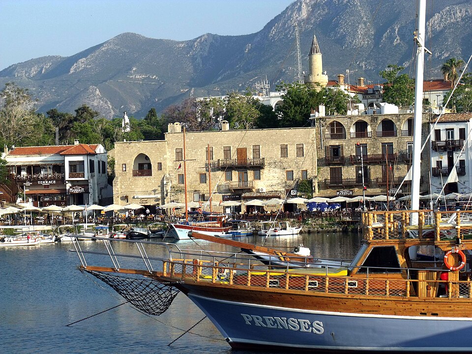
Northern Cyprus adds major layers of the same island’s history. Kyrenia Harbour curves beside a castle with Byzantine, Lusignan and Venetian phases. Saint Hilarion Castle climbs the mountains above the coast, and Bellapais Abbey preserves Gothic monastic architecture in the foothills. Famagusta’s walled city contains the former Cathedral of Saint Nicholas, now Lala Mustafa Pasha Mosque. Salamis, north of Famagusta, preserves a large ancient city with a theatre, baths and colonnaded spaces.
Büyük Han brings Ottoman urban history into North Nicosia, while Apostolos Andreas Monastery stands near the end of the Karpas Peninsula. Elsewhere, Kourion’s theatre overlooks the south coast, Kolossi Castle recalls the Knights Hospitaller, and Cape Greco shows a different coastal landscape. A sight’s historical importance does not automatically give it UNESCO inscription. The twenty pins identify places to learn about; current access, worship arrangements and crossing requirements should be checked separately.
People of Cyprus
Local communities, displacement, diaspora and public figures.
- Who designed the Republic’s flag?
- Turkish Cypriot artist İsmet Güney designed its copper-coloured island and olive branches.
- Who was Zeno of Citium?
- A philosopher born near present-day Larnaca in the fourth century BCE who founded Stoicism in Athens.
- Why do population figures differ?
- Statistics for the Republic-controlled area, estimates for the whole island and counts by citizenship or residence describe different populations. They should always be labelled by scope and date.
More about Cyprus: people & society
Greek Cypriots and Turkish Cypriots are the island’s two principal communities. Armenian, Maronite and Latin communities also have long histories, alongside people who have moved to Cyprus for work, study, family or refuge. A person’s citizenship, language, religion and sense of identity are related in different ways and should not be treated as interchangeable. Whole-island population estimates and statistics for the Republic-controlled area describe different geographical scopes.
Intercommunal violence and the events of 1974 displaced people from homes across the island. Many Greek Cypriots moved south and many Turkish Cypriots moved north; missing persons, property and access to places of worship remain significant issues. The UN-backed Committee on Missing Persons works to identify and return remains to families from both communities. Diaspora communities in Britain, Australia and elsewhere maintain family and cultural connections with Cyprus.
Zeno of Citium, born in the fourth century BCE at a city near present-day Larnaca, founded Stoicism in Athens. Makarios III combined leadership of the Church of Cyprus with the role of the Republic’s first president, although those offices are not constitutionally the same. Turkish Cypriot artist İsmet Güney designed the Republic’s flag, whose copper-coloured island and olive branches express a different kind of public legacy. Contemporary writers, artists and athletes add to an identity broader than political division.