Facts about Armenia
Explore Armenia from Yerevan and the Ararat plain to Lake Sevan, the forests of Tavush and the mountains of Syunik. Place ten provinces and the capital, twenty cities and sixteen sights, discover ten illustrated topics and begin Armenian.
- Capital
- Yerevan
- Currency
- Armenian dram (AMD)
- State language
- Armenian
- Administrative areas
- 10 provinces + Yerevan
- Highest peak
- Aragats, about 4,090 m
- UNESCO World Heritage
- 3 properties
Armenia · 0 of 20 rounds passed
Two timed rounds per topic, 20 seconds a question
Armenia is a landlocked South Caucasus country bordered by Georgia, Azerbaijan, Iran and Türkiye. Yerevan stands on the Hrazdan; Gyumri anchors the northwestern Shirak plateau, and Vanadzor lies in northern Lori. The high basin of Lake Sevan occupies much of Gegharkunik, while southern Syunik reaches the Iranian border.
The guide uses administrative reference boundaries, including the Armenian exclave of Artsvashen. It distinguishes recognised territory from present control. Nagorno-Karabakh is within internationally recognised Azerbaijan, not an Armenian province. The maps are for geographic learning; border arrangements and access need current official checks.
Geography of Armenia
A landlocked highland country, ten provinces and a capital on the Hrazdan.
- Where is Armenia?
- In the South Caucasus, bordered by Georgia, Azerbaijan, Iran and Türkiye. It is landlocked.
- Is Mount Ararat in Armenia?
- No. It is in Türkiye. Mount Aragats, at about 4,090 metres, is the highest peak within Armenia.
- How many provinces does Armenia have?
- Ten provinces, or marzes. Yerevan is a separate community with capital status, not an eleventh province.
More about Armenia: geography
Armenia lies in the South Caucasus, in the northeastern part of the Armenian Highland. Georgia is to the north, Azerbaijan to the east, Iran to the south and Türkiye to the west. Azerbaijan’s Nakhchivan exclave is southwest of Armenia. The country has no coastline. Mountain ridges, volcanic plateaus and deeply cut valleys make short distances on a map feel much longer on the ground.
Mount Aragats, a volcanic massif northwest of Yerevan, reaches about 4,090 metres and is the country’s highest peak. Mount Ararat is a powerful Armenian cultural symbol and can be seen from the Yerevan area, but it stands in Türkiye. Lake Sevan occupies a high basin in the east at roughly 1,900 metres. Its drainage basin covers a much larger area than the lake’s water surface.
The administrative map has ten provinces, called marzes, and separate Yerevan. The Hrazdan flows from Lake Sevan through the capital to the Aras, also called the Arax. The Aras follows stretches of Armenia’s borders before joining the Kura in Azerbaijan. These river systems connect a landlocked country to the Caspian drainage basin.
History of Armenia
Urartian inscriptions, medieval kingdoms and two modern republics.
- When did Armenia adopt Christianity?
- In the early fourth century, traditionally dated to 301. The traditional date should be distinguished from the broader historical chronology.
- When did modern Armenia become independent?
- The first modern republic was established in 1918. The present republic became independent from the Soviet Union in 1991.
- What happened at Erebuni?
- An Urartian inscription records the foundation of a fortress there in 782 BCE. The site is within modern Yerevan.
More about Armenia: history
Urartu was an Iron Age kingdom centred around Lake Van, now in Türkiye. Its presence extended into the territory of modern Armenia: an inscription records the foundation of Erebuni in 782 BCE, in today’s Yerevan. Later Armenian kingdoms occupied different territories at different times. Tigranes II, known as Tigranes the Great, ruled an expansive kingdom in the first century BCE; that realm was far larger than the present republic.
Armenia adopted Christianity as a state religion in the early fourth century, traditionally dated to 301. Medieval monasteries became centres of worship, manuscript production and learning. Political authority shifted between Armenian kingdoms and larger empires. The Armenian Kingdom of Cilicia developed much farther southwest, near the Mediterranean, and should not be confused with the territory of the modern state.
The Armenian Genocide took place in the Ottoman Empire during the First World War and destroyed communities across a wide region. A first modern Republic of Armenia was established in 1918; Soviet rule followed in 1920. The present republic became independent in 1991. The 1988 earthquake, the Karabakh wars and the arrival of more than 100,000 refugees from Karabakh in 2023 have all shaped recent Armenian society.
Armenian language
An independent Indo-European branch with its own alphabet and two modern standards.
- What language family does Armenian belong to?
- Indo-European. Armenian forms its own branch, distinct from Georgian’s Kartvelian family and Azerbaijani’s Turkic family.
- Who created the Armenian alphabet?
- Mesrop Mashtots is credited with its creation in the early fifth century, conventionally 405. The original alphabet had 36 letters.
- Which Armenian do the lessons teach?
- Eastern Armenian, the main standard used in the republic. Western Armenian is an important standard in many diaspora communities.
More about Armenia: language
Armenian, called hayeren, forms its own branch of the Indo-European language family. Its position in the Caucasus does not make it part of the Kartvelian family of Georgian or the Turkic family of Azerbaijani. Armenian is the state language of the republic. Eastern Armenian is the principal modern standard used there; Western Armenian is especially important in many diaspora communities.
Mesrop Mashtots is credited with creating the Armenian alphabet in the early fifth century, conventionally dated to 405. The original alphabet had 36 letters; later additions and different spelling conventions mean that modern counts need a stated context. Classical Armenian, or Grabar, remains important in church and historical texts. Manuscripts in the Matenadaran show the long relationship between writing, scholarship and art.
Բարև, barev, is an everyday hello. Շնորհակալություն, shnorhakalutyun, means thank you. The linked lessons introduce Eastern Armenian with Armenian script and pronunciation guidance. A colon-shaped mark, ։, is the Armenian full stop. Armenian communities also use other languages, and knowledge of Russian or English varies with the person and setting.
Culture of Armenia
Duduk music, carved cross-stones, circle dances and the life of the written word.
- What is a duduk?
- A double-reed woodwind instrument traditionally made from apricot wood. UNESCO recognises duduk music as living heritage.
- What are khachkars?
- Carved memorial cross-stones combining a cross with ornamental patterns. Their symbolism and craftsmanship are UNESCO-listed intangible heritage.
- What is Kochari?
- A traditional group dance performed at celebrations and gatherings. UNESCO inscribed the practice in 2017.
More about Armenia: culture
The duduk is a double-reed woodwind instrument traditionally made from apricot wood. Its warm sound accompanies different kinds of songs and ceremonies. UNESCO recognises duduk music as intangible cultural heritage. Komitas collected and arranged folk music, while Aram Khachaturian is known internationally for orchestral and ballet works, including the Sabre Dance from Gayane.
Khachkars are carved memorial cross-stones with crosses and intricate ornamental designs. Their craftsmanship and symbolism form another UNESCO-listed living tradition. Monasteries preserve many examples, but khachkars also appear in cemeteries and public spaces. Kochari is a group dance performed at celebrations, linking participants through a shared rhythm and repeated steps.
Armenian cultural life extends from manuscript illumination and carpet weaving to cinema, contemporary art and a wide literary diaspora. Vardavar is associated with summer water festivities; Trndez has bonfire customs. Religious meaning, seasonal celebration and family practice overlap in different ways. Regional and diaspora experiences give these traditions many forms rather than one fixed national script.
Economy of Armenia
Technology, services, mining and farming in a mountain economy.
- What currency does Armenia use?
- The Armenian dram, abbreviated AMD. It was introduced in November 1993.
- What does Armenia produce?
- Its economy includes software and other services, copper and molybdenum mining, farming, wine and brandy production, and tourism.
- Why are transport links important?
- Armenia is landlocked and has a small domestic market. Connections through Georgia and Iran are important for external trade; current crossing arrangements need separate checks.
More about Armenia: economy
Yerevan is the main centre for administration, finance, education and many services. Armenia also has a substantial technology sector, including software and engineering businesses. Tourism links the capital with monasteries, archaeological sites, vineyards, mountain towns and Lake Sevan. The benefits and pressures of these activities are unevenly distributed between urban and rural areas.
Copper and molybdenum mining are significant, particularly in Syunik. Farming includes grapes, apricots, vegetables and livestock, with growing conditions changing sharply by elevation. Wine and brandy have important commercial and cultural roles. Energy comes from several sources, including the Armenian nuclear power plant near Metsamor, hydropower, thermal generation and expanding solar installations.
The currency is the Armenian dram, abbreviated AMD, introduced in November 1993. Armenia’s small domestic market makes external trade, transport links and investment important. Georgia and Iran provide key land connections. Border arrangements and trade conditions can change, so a learning map should not be treated as a guide to which crossing is open. Mining, water use and energy decisions also affect habitats and local livelihoods.
Politics of Armenia
Parliamentary government, a separate capital and regional relationships.
- Is Armenia a parliamentary republic?
- Yes. The prime minister leads the government, the president is head of state, and the National Assembly is the unicameral legislature.
- Is Armenia in the European Union?
- No. It has a Comprehensive and Enhanced Partnership Agreement with the EU and is a member of the Eurasian Economic Union.
- Is Nagorno-Karabakh an Armenian province?
- No. It lies within internationally recognised Azerbaijan. More than 100,000 ethnic Armenians fled to Armenia after Azerbaijan’s September 2023 takeover.
More about Armenia: politics
Armenia’s constitutional system is a parliamentary republic. The National Assembly is the unicameral legislature. The prime minister leads the government, while the president is head of state. The constitutional changes approved in 2015 brought a transition to this parliamentary system, completed in 2018. Yerevan is the capital and a separate community; it is not one of the ten provinces.
The protest movement commonly called the Velvet Revolution brought a change of government in 2018. Institutions, elections, civil society and the rule of law remain important subjects in the country’s public life. Armenia belongs to the Eurasian Economic Union and has a Comprehensive and Enhanced Partnership Agreement with the European Union. A partnership agreement is distinct from EU membership.
This guide maps Armenia’s administrative reference areas. Nagorno-Karabakh lies within internationally recognised Azerbaijan and is not an Armenian province. Azerbaijan took control of the remaining Armenian-controlled territory there in September 2023, followed by the departure of more than 100,000 ethnic Armenians to Armenia. The reference map includes Artsvashen, an Armenian exclave outside Armenian government control, and does not show current military positions or border demarcation.
Nature of Armenia
High lakes, northern forests, dry valleys and the mountains of the south.
- Why is Lake Sevan environmentally important?
- It is a major high-altitude freshwater ecosystem. Water diversion lowered its level during the Soviet period, making water management and ecological recovery continuing concerns.
- Does Armenia have forests?
- Yes. Forested areas include parts of the north and northeast, such as Dilijan, and parts of southern Syunik. Other areas are much drier or above the tree line.
- Are all protected areas national parks?
- No. Dilijan and Arevik are national parks; Khosrov Forest and Shikahogh are state reserves. The categories have different purposes and rules.
More about Armenia: nature & wildlife
Armenia’s habitats range from dry lowland and mountain steppe to broadleaf forest, alpine meadows and high rocky terrain. Forests are especially associated with parts of the north and northeast, including Dilijan National Park. Southern Syunik holds a different mosaic of wooded valleys, dry slopes and high mountains. These differences reflect elevation, exposure and rainfall rather than a single climate across the whole country.
Lake Sevan is an important freshwater ecosystem and a central environmental concern. Soviet-era diversion lowered its level substantially, and later management has sought to restore and protect the lake. Water quality, shoreline development and fish populations are connected issues. The endemic Sevan trout is culturally well known, but the lake’s ecosystem cannot be understood through one species alone.
The southern mountains support rare wildlife including the Persian, or Caucasian, leopard. Bezoar goats, Armenian mouflon and many birds use other parts of the highland landscape. Khosrov Forest and Shikahogh are state reserves; Dilijan and Arevik are national parks. These designations are not interchangeable. Protected-area rules, conservation work and habitat connections matter as much as the location of a park on a map.
Food of Armenia
Lavash, grilled dishes, slow-cooked wheat and recipes shared across a wider region.
- What is lavash?
- A thin flatbread traditionally baked in a tonir oven. UNESCO recognises the preparation and cultural meaning of lavash in Armenia.
- What is Armenian harissa?
- A thick dish of wheat and meat, commonly chicken, cooked slowly. It is different from the North African chilli paste of the same name.
- What is tan?
- A drink made with yoghurt, water and often salt. Spas is a yoghurt-based soup, while gata is a family of sweet pastries.
More about Armenia: food & cuisine
Lavash is a thin flatbread traditionally baked against the hot wall of a tonir oven. UNESCO recognises its preparation, meaning and appearance as an expression of culture in Armenia. Making, sharing and storing the bread connect cooking with household and community life. Related breads and techniques also belong to neighbouring food cultures; recognition does not imply exclusive ownership.
Khorovats refers to grilled food, often meat cooked on skewers with vegetables alongside. Tolma includes stuffed leaves and vegetables, with meat-based and meat-free preparations. Harissa is a thick, slow-cooked dish combining wheat and meat, commonly chicken. It is different from the North African chilli paste with the same English spelling. Recipes and serving customs vary between families and communities.
Spas is a yoghurt-based soup, while tan is a drink made with yoghurt, water and often salt. Gata is a family of sweet pastries, with regional variations in shape and filling. Apricots, walnuts, herbs and preserved fruits appear widely. Grape wine and brandy have long associations with Armenia; pomegranate wines are also made. Markets and home cooking reveal a wider range than a short list of national dishes can capture.
Landmarks of Armenia
Rock-cut churches, ancient temples, manuscript collections and a lake peninsula.
- How many World Heritage properties does Armenia have?
- Three: Haghpat and Sanahin; Echmiatsin’s cathedral and churches with Zvartnots; and Geghard with the Upper Azat Valley. Each property can include several monuments.
- Are Tatev and Noravank World Heritage properties?
- Neither is part of Armenia’s three inscribed properties. Both are important monasteries, but cultural importance and UNESCO inscription are different things.
- What can you learn at the Matenadaran?
- About Armenian manuscripts, writing, art and scholarship. The institute and museum in Yerevan preserve a major historical manuscript collection.
More about Armenia: landmarks
Armenia’s three World Heritage properties bring several monuments together: Haghpat and Sanahin monasteries; the Cathedral and Churches of Echmiatsin and the Archaeological Site of Zvartnots; and the Monastery of Geghard and the Upper Azat Valley. Three properties do not mean only three buildings. Geghard combines built structures with churches and tombs cut into the rock.
Garni’s reconstructed colonnaded temple represents a different layer of the region’s past. Khor Virap stands on the Ararat plain with the mountain across the Turkish border beyond it. Noravank occupies a red-rock canyon in Vayots Dzor, while Tatev stands above the Vorotan gorge in Syunik. Neither Noravank nor Tatev is one of the three inscribed World Heritage properties.
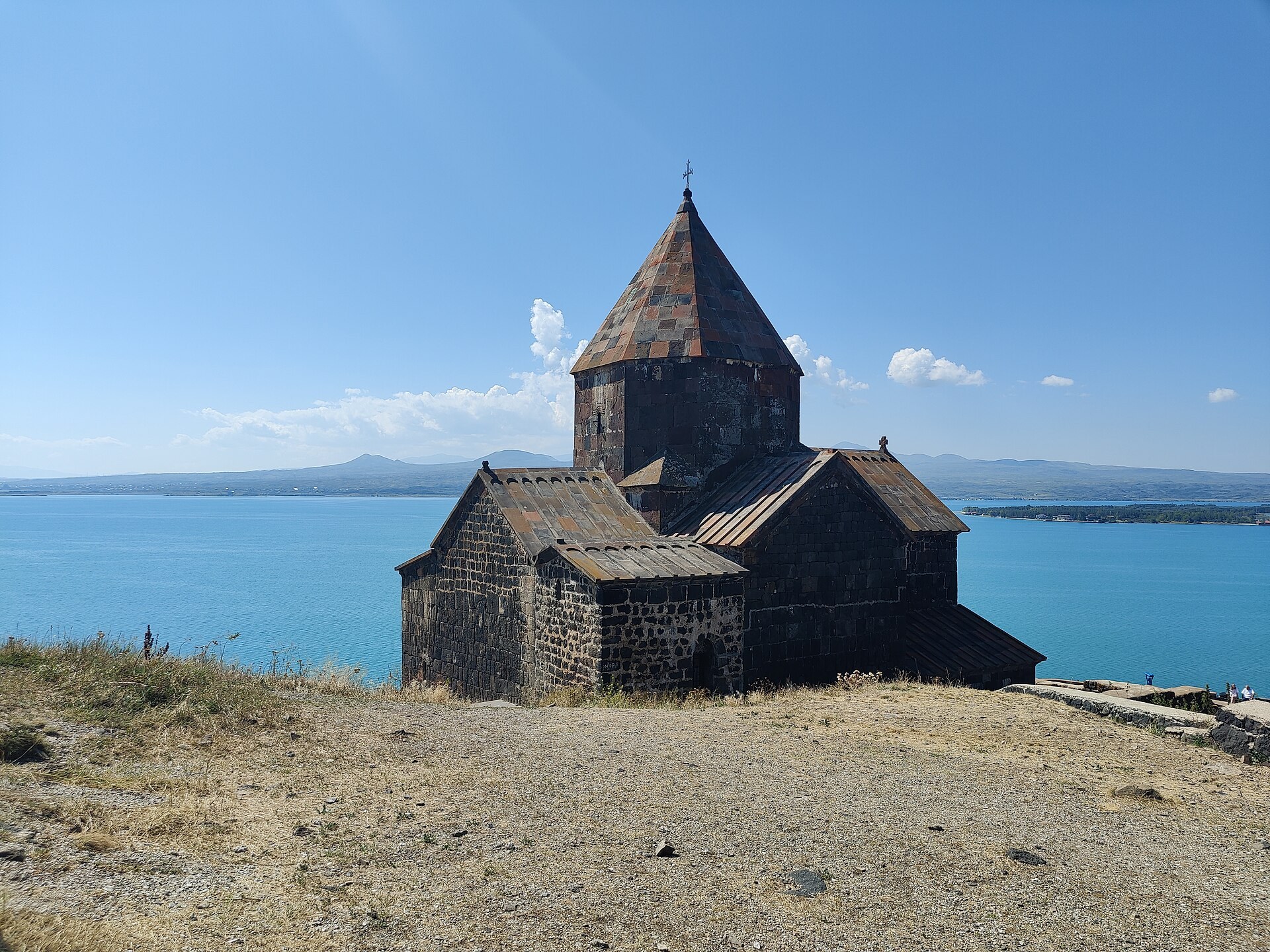
In Yerevan, the Matenadaran preserves and displays manuscripts, and the Cascade links a monumental stairway with modern art spaces. Tsitsernakaberd commemorates the Armenian Genocide. Beyond the capital, Sevanavank stands on a peninsula that was formerly an island. The sights map locates sixteen places across the country; pins identify monuments or representative landscape points rather than complete site boundaries.
People of Armenia
Hayastan, local communities and a diaspora connected across many countries.
- What do Armenians call their country?
- Hayastan, written Հայաստան. The Armenian language is called hayeren.
- Do all Armenians live in Armenia?
- No. Large and diverse diaspora communities live in many countries. Ancestry, citizenship and residence are separate concepts.
- Is Armenia home to other communities?
- Yes. Yezidi, Russian, Assyrian, Kurdish and other communities are part of the republic’s society alongside the Armenian majority.
More about Armenia: people & society
Armenians call their country Hayastan and themselves hay. The republic and the Armenian diaspora are related but different communities: Armenian ancestry does not automatically imply residence or citizenship in Armenia. Diaspora histories include long-established trading and religious communities, the consequences of the Armenian Genocide and later migration. Family connections extend across Russia, the United States, France, the Middle East and many other places.
Most residents identify as ethnic Armenian, but Armenia is also home to Yezidi, Russian, Assyrian, Kurdish and other communities. Religion, ethnicity, language and nationality describe different parts of identity. The Armenian Apostolic Church has a major historical role, while other Christian communities and other faiths are also present. No individual’s beliefs should be inferred from a national or family label.
Gyumri’s artistic traditions, Vanadzor’s industrial past, rural farming and life in Yerevan give different perspectives on the country. The 1988 earthquake and displacement connected with the Karabakh conflict have affected many families. Writers and musicians such as William Saroyan, Charles Aznavour and Aram Khachaturian illustrate diaspora and regional connections without standing in for every Armenian experience.