Facts about Uzbekistan
Explore Uzbekistan through Samarkand’s tiled squares, Bukhara’s trading streets and Khiva’s walled inner town, then look beyond the monuments to the Fergana Valley, Karakalpakstan and the western Tian Shan. Learn its regions, cities and waters, discover the people and traditions behind the places, and begin speaking Uzbek.
- Capital
- Tashkent
- Population
- 38.2 million, January 2026
- Area
- 448,900 km²
- Currency
- Uzbek sum (UZS)
- State language
- Uzbek
- Administrative areas
- 12 regions + republic + capital
Uzbekistan · 0 of 20 rounds passed
Two timed rounds per topic, 20 seconds a question
Uzbekistan sits in Central Asia between Kazakhstan, Kyrgyzstan, Tajikistan, Afghanistan and Turkmenistan. The Kyzylkum occupies much of the centre and north, while irrigated oases, the Zarafshan valley and the Fergana Valley support many of its settlements. Tashkent is the national capital; Samarkand, Bukhara and Khiva preserve different chapters of the Silk Roads. Nukus anchors Karakalpakstan in the northwest, and Termez faces Afghanistan across the Amu Darya.
The country has twelve regions, the autonomous republic of Karakalpakstan and separately administered Tashkent City. About 38.2 million people lived here on 1 January 2026. Craft workshops, markets, museums and contemporary city life are as much part of the country as its medieval monuments. In the northeast, the western Tian Shan rises above Tashkent’s plain; in the northwest, the retreat of the Aral Sea has transformed livelihoods and landscapes.
Geography of Uzbekistan
Desert, irrigated oases and the Fergana Valley in a country surrounded by landlocked neighbours.
- What does doubly landlocked mean?
- Uzbekistan has no ocean coastline, and all five of its neighbours are also landlocked. Liechtenstein is the other doubly landlocked country.
- Which countries share the Fergana Valley?
- Uzbekistan, Kyrgyzstan and Tajikistan. The valley is a geographical region divided by national borders, rather than a single Uzbek administrative area.
- Is the Aral Sea outline on the map its current shoreline?
- No. It is a historical reference outline from Natural Earth. The South Aral Sea has fragmented and shrunk, and water levels vary. Lake Aydar is a separate inland water body farther southeast.
More about Uzbekistan: geography
Uzbekistan is doubly landlocked: it has no ocean coastline, and neither does any of its five neighbours. The Kyzylkum stretches between the Amu Darya and Syr Darya systems. Mountains rise in the east and southeast, while the Fergana Valley extends across Uzbekistan, Kyrgyzstan and Tajikistan. Irrigation makes the contrast between cultivated oases and dry surrounding land especially visible.
The Amu Darya passes Termez along the Afghan frontier and continues towards Khorezm and Karakalpakstan. The Syr Darya crosses the Fergana Valley and later runs beside the Gulistan area before reaching Kazakhstan. The Zarafshan supports the Samarkand oasis. Lake Aydar lies north of the Nuratau mountains, while Charvak is a mountain reservoir northeast of Tashkent. The South Aral Sea outline on the learning map is a historical reference, not a measure of today’s water extent.
History of Uzbekistan
Sogdian trading cities, Timurid architecture, khanates and independence in 1991.
- When did Uzbekistan become independent?
- Independence was declared on 31 August 1991. The national holiday is celebrated on 1 September.
- Who were Timur and Ulugh Beg?
- Timur established an empire with Samarkand as its capital in the late fourteenth century. His grandson Ulugh Beg was a fifteenth-century ruler and astronomer associated with Samarkand’s observatory.
- Was the Silk Road one road?
- It was a network of routes connecting many regions. Merchants, ideas, religions and technologies moved along different branches; Samarkand, Bukhara and Khiva had distinct roles over time.
More about Uzbekistan: history
The places within modern Uzbekistan have belonged to many political and cultural worlds. Sogdian merchants helped connect Central Asian towns with routes extending into China and farther west. Islamic rule and scholarship added new layers from the eighth century. Bukhara became a major centre under the Samanids, and Samarkand flourished under Timur in the late fourteenth century. His grandson Ulugh Beg combined rule with astronomical research in the fifteenth century.
Later Uzbek dynasties and the khanates of Bukhara, Khiva and Kokand shaped the region. Russian imperial expansion in the nineteenth century brought conquest and protectorates. The Uzbek Soviet Socialist Republic was established during Soviet territorial reorganisation in 1924. Uzbekistan declared independence on 31 August 1991, with Independence Day celebrated on 1 September. Modern national borders should not be projected backwards onto scholars, traders and empires whose lives crossed a much wider region.
Language of Uzbekistan
A Turkic state language written in Latin, with Cyrillic still visible in everyday life.
- Is Uzbek related to Turkish or Persian?
- Uzbek is Turkic, in the Karluk branch. Turkish is in another Turkic branch. Persian and Tajik are Iranian languages, although Persian has contributed many words to Uzbek.
- Does Uzbek use Latin or Cyrillic?
- Uzbekistan adopted a Latin-based alphabet in 1993, with later changes. Cyrillic remains common in everyday use, so both scripts are visible.
- How do you say hello and thank you?
- Salom is a common informal hello, and rahmat means thank you. Assalomu alaykum is another widely used greeting. The Uzbek lessons include native spelling and pronunciation guidance.
More about Uzbekistan: language
Uzbek belongs to the Karluk branch of the Turkic language family, alongside Uyghur. Suffixes do much of its grammatical work, and verbs commonly come near the end of a sentence. Chagatai was an important earlier literary language, used by Alisher Navoi and other writers. Persian and Arabic have also contributed vocabulary. Uzbek is the state language, but Tajik, Karakalpak, Russian and other languages are part of the country’s daily life.
A Latin-based alphabet was adopted in 1993, with later adjustments. Cyrillic remains common, so visitors may encounter the same place in several spellings. Karakalpak is a distinct Turkic language, and Tajik is an Iranian language particularly important in cities including Bukhara and Samarkand. Salom is a useful informal hello; assalomu alaykum is another widely used greeting. Rahmat means thank you. The linked Uzbek lessons use Latin spelling and pronunciation guidance.
Culture of Uzbekistan
Ikat textiles, blue ceramics, Shashmaqom music and Khorezm’s Lazgi dance.
- What is ikat?
- A technique in which threads are resist-dyed before weaving to create patterned cloth. Margilan is an important centre for atlas and adras silk and mixed-fibre textiles.
- What are Shashmaqom and Lazgi?
- Shashmaqom is a classical vocal and instrumental music tradition shared with Tajikistan. Lazgi is an expressive dance associated with Khorezm. Both are recognised by UNESCO.
- Why is Rishtan known for ceramics?
- Its workshops maintain distinctive pottery traditions, especially glazed blue and turquoise decoration. The town lies in Fergana Region, between Kokand and Fergana city.
More about Uzbekistan: culture
Uzbekistan’s craft traditions are strongly regional. Margilan is associated with atlas and adras textiles, whose patterns are created by dyeing threads before weaving. Rishtan is known for glazed ceramics, often in blue and turquoise. Suzani embroidery decorates textiles with floral and other motifs. The embroidered skullcap, often called a doʻppi, takes different forms across the country rather than following a single national pattern.
Shashmaqom combines vocal and instrumental music with poetry and is a shared heritage of Uzbekistan and Tajikistan. Lazgi is associated with Khorezm and uses expressive movements of the hands and body. Navruz marks spring renewal with visits, performances and shared food. Contemporary culture includes cinema, literature, theatre and popular music. Mahallas, neighbourhood communities with social and administrative roles, help connect family life with the wider city or village.
Economy of Uzbekistan
Gold, textiles, farming and manufacturing alongside a growing service economy.
- What currency does Uzbekistan use?
- The Uzbek sum, written soʻm in Uzbek and abbreviated UZS. This guide does not quote exchange rates, which change.
- Is cotton the whole economy?
- No. Cotton and textiles matter, alongside gold and copper mining, manufacturing, other farming and services. Muruntau is a major gold mine, and Asaka is associated with car production.
- What is Afrosiyob?
- The name of Uzbekistan’s high-speed passenger train service, including connections between Tashkent, Samarkand and Bukhara. Check the railway’s current timetable for an actual journey.
More about Uzbekistan: economy
Gold mining, copper, natural gas, agriculture, manufacturing and services all contribute to Uzbekistan’s economy. Muruntau in Navoi Region is a major open-pit gold mine. Asaka in Andijan Region is associated with automobile production. Cotton remains important, with more processing into yarn and textiles at home. Orchards, vegetables and other crops also depend on irrigation, making water management an economic as well as an environmental issue.
The currency is the Uzbek sum, also written soʻm, abbreviated UZS. Economic reforms since 2017 have changed currency exchange, trade and the role of private enterprise, while state-owned businesses remain influential. Energy demand and import needs make older descriptions of the country simply as a major gas exporter misleading. Tourism connects heritage cities with hotels, railways and small businesses; Afrosiyob trains link Tashkent with Samarkand and Bukhara. Employment opportunities and migration also shape household incomes.
Politics of Uzbekistan
A presidential republic, a two-chamber parliament and a distinct autonomous republic.
- How many top-level administrative areas are there?
- Fourteen: twelve regions, the autonomous republic of Karakalpakstan and Tashkent City. Karakalpakstan and the capital are not counted among the twelve regions.
- Is Tashkent the centre of Tashkent Region?
- The national capital is a separately administered city. Nurafshon is the administrative centre of the surrounding Tashkent Region.
- What is the Oliy Majlis?
- Uzbekistan’s parliament, comprising the Legislative Chamber and the Senate. The constitution describes the institutions; OSCE election reports assess how political competition operates in practice.
More about Uzbekistan: politics
Uzbekistan is a presidential republic. Its constitution was revised following a referendum in 2023. The Oliy Majlis has two chambers: the Legislative Chamber and the Senate. The president is head of state, while the prime minister leads the Cabinet of Ministers. National institutions are based in Tashkent. Formal institutions coexist with strong executive power; the OSCE’s assessment of the 2024 parliamentary election described limited political choice.
The administrative map has fourteen top-level areas: twelve regions, Karakalpakstan and Tashkent City. Karakalpakstan has its own constitution and representative institutions within Uzbekistan’s constitutional framework. Tashkent City is separate from Tashkent Region, whose centre is Nurafshon. The country joined the United Nations in 1992 and was a founding member of the Shanghai Cooperation Organisation in 2001. Regional relations involve shared water, energy, trade routes and borders.
Nature & Wildlife of Uzbekistan
Saxaul desert, riverine woodland and western Tian Shan habitats under water pressure.
- Why did the Aral Sea shrink?
- Large-scale diversion of the Amu Darya and Syr Darya for irrigation reduced inflow. Retreating water damaged fisheries and exposed salty seabed, with consequences for health, livelihoods and ecosystems.
- What is the Aralkum?
- The desert formed on the exposed bed of the Aral Sea. Saxaul planting helps stabilise some exposed ground, but does not restore the former sea.
- Does Uzbekistan have mountain habitats?
- Yes. The western Tian Shan and southeastern ranges contrast with its deserts and oases. The Western Tien-Shan World Heritage property is shared with Kazakhstan and Kyrgyzstan.
More about Uzbekistan: nature & wildlife
The country’s habitats range from Kyzylkum desert and the Ustyurt Plateau to mountain forests, grasslands and alpine terrain. Saxaul is adapted to dry landscapes, while tugai woodland grows along river floodplains. The western Tian Shan supports rich plant diversity, including wild fruit and nut trees. Uzbekistan shares the Western Tien-Shan World Heritage property with Kazakhstan and Kyrgyzstan.
The Aral Sea crisis followed large-scale diversion of river water for irrigation, particularly during the Soviet period. Retreating water left the Aralkum on the exposed seabed, while dust, salinity and the collapse of fisheries affected nearby communities. Planting saxaul is one response to the exposed land. Saiga antelopes occur in the wider Ustyurt landscape; their global conservation assessment improved in 2023, but local populations still face pressures. Mountain wildlife and river wetlands have different conservation needs from the desert.
Food & Cuisine of Uzbekistan
Palov, oven-baked samsa, steamed manti and the shared table of a choyxona.
- What is palov?
- A rice dish usually prepared with carrots, meat, oil and seasonings. Also called plov or osh, it has regional variations and important traditions of collective preparation and sharing.
- How are samsa and manti different?
- Samsa are baked savoury pastries, often filled with meat and onions. Manti are steamed dumplings. Fillings and recipes vary.
- What is a choyxona?
- A teahouse, often serving food as well as tea. Green and black tea are both common, and local customs vary by household, place and occasion.
More about Uzbekistan: food & cuisine
Palov, also called plov or osh, combines rice with carrots, meat, oil and seasonings, with ingredients and methods varying by place and occasion. Its preparation and sharing carry social meaning at family gatherings and celebrations. UNESCO recognises palov culture and tradition. Non is bread often baked in a tandir oven, with regional differences in shape, decoration and texture.
Samsa are savoury pastries, often filled with meat and onion; manti are steamed dumplings. Lagman combines noodles with meat and vegetables, while shurpa is a soup and chalop is a cold dairy-based preparation. Green and black tea are common in homes and choyxonas, or teahouses. Hospitality customs vary, so following a host’s lead is more useful than assuming every meal follows the same ritual. Contemporary menus also reflect the country’s many communities and international connections.
Landmarks of Uzbekistan
Registan, Bukhara’s monuments, Khiva’s inner town and places beyond the classic circuit.
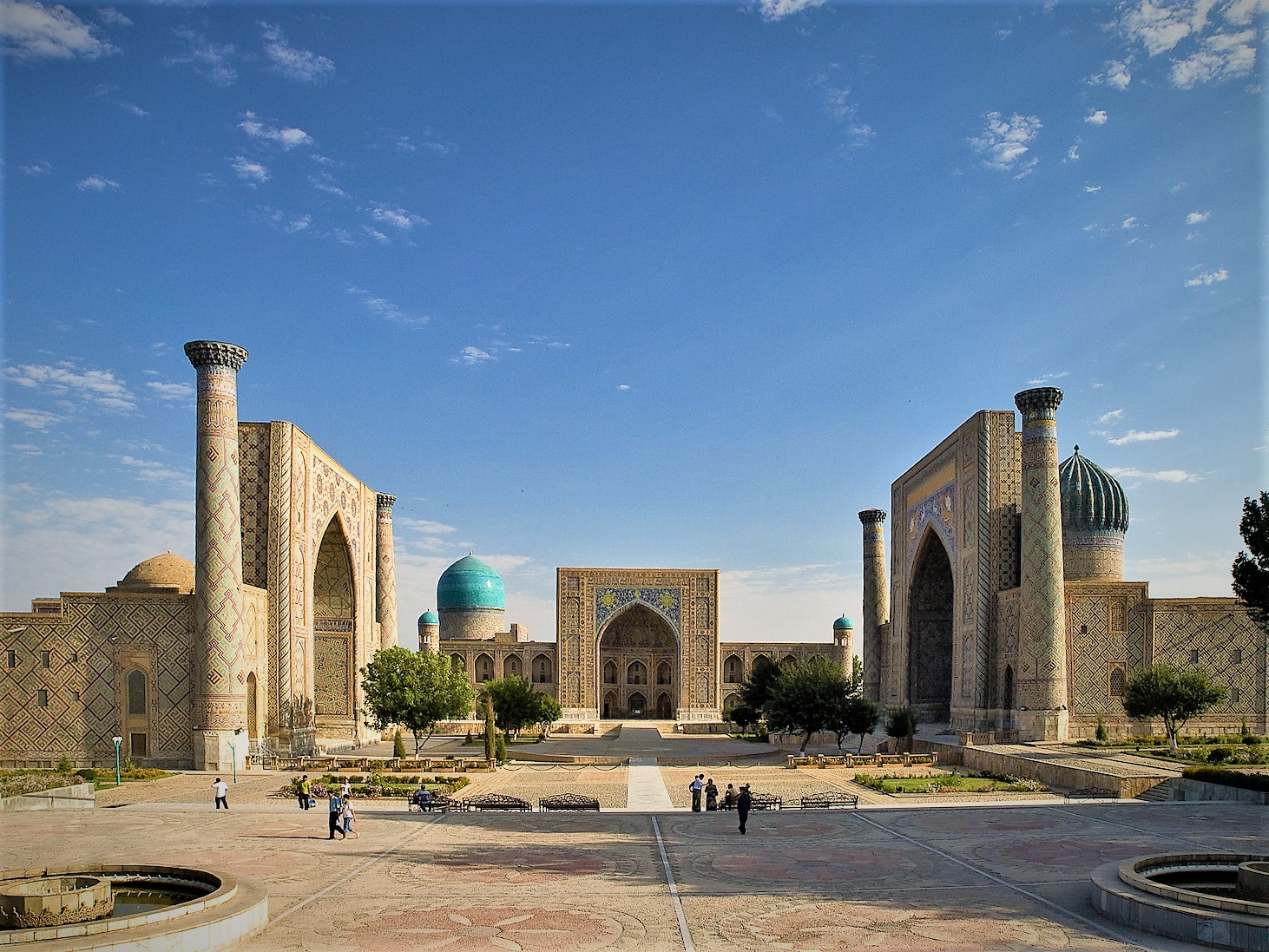
- What is the Registan?
- A square in Samarkand framed by the Ulugh Beg, Sher-Dor and Tilya-Kori madrasas. They were built in different periods rather than as a single construction project.
- Is Itchan Kala all of Khiva?
- Itchan Kala is Khiva’s walled inner town. The modern city extends beyond it. Its UNESCO inscription covers the historic inner area.
- Where is the Savitsky Museum?
- In Nukus, the capital of Karakalpakstan. Its collections include Karakalpak heritage and important twentieth-century art; it is not in the former fishing port of Moynaq.
More about Uzbekistan: landmarks
Samarkand’s Registan is framed by three madrasas built in different periods. Nearby, Gur-e-Amir is the dynastic mausoleum associated with Timur, and Shah-i-Zinda is a layered ensemble of mausoleums. Ulugh Beg’s Observatory connects the city with fifteenth-century astronomy. Bukhara’s historic centre includes the Kalyan ensemble, the Ark and the Samanid Mausoleum. Khiva’s Itchan Kala preserves a walled inner town with mosques, madrasas, palaces and minarets.
Shahrisabz preserves the monumental portal of Ak-Saray, Timur’s palace. Tashkent adds Chorsu Bazaar, the State Museum of History and distinctive metro stations. In Nukus, the Savitsky Museum combines Karakalpak heritage with important art collections. Ayaz-Kala’s ruined fortresses stand farther east in Karakalpakstan, while Fayaz Tepe near Termez recalls the region’s Buddhist history. These sites span centuries and landscapes; they form a countrywide learning selection, not a single-day itinerary.
People & Society of Uzbekistan
Central Asia’s largest population, with many languages, communities and regional identities.
- What is Uzbekistan’s population?
- The National Statistics Committee reported 38,236,704 permanent residents on 1 January 2026, rounded here to about 38.2 million.
- Does everyone in Uzbekistan speak Uzbek at home?
- No. Uzbek is the state language, while Tajik, Karakalpak, Russian and other languages are also used. Language, ethnicity and citizenship describe different aspects of identity.
- Why are Navoi, Ibn Sina and al-Khwarizmi associated with the country?
- Navoi’s Chagatai writing is central to Uzbek literary heritage. Ibn Sina was born near Bukhara, and al-Khwarizmi is associated with historical Khwarazm. Their careers belonged to wider regional intellectual worlds.
More about Uzbekistan: people & society
Uzbekistan’s National Statistics Committee counted about 38.2 million permanent residents on 1 January 2026. Uzbeks form the majority, alongside Tajiks, Karakalpaks, Kazakhs, Russians, Kyrgyz, Turkmens, Koreans and other communities. The Fergana Valley and the Samarkand and Tashkent areas are important population centres. Nukus and the lower Amu Darya have a different settlement history from the densely cultivated eastern valleys.
Most believers identify with Sunni Islam, while other religious communities and secular ways of life also form part of society. Alisher Navoi is celebrated for Chagatai literature. Ibn Sina, known in Europe as Avicenna, was born near Bukhara and wrote the Canon of Medicine. Al-Khwarizmi’s name survives in the word algorithm. These scholars belonged to wider intellectual networks; contemporary citizenship and ethnic labels do not fully describe their historical worlds. Today, education, work, sport and migration connect Uzbekistan with places far beyond Central Asia.