Facts about Turkmenistan
Explore Turkmenistan from Ashgabat’s marble avenues and the Kopet Dag foothills to the Karakum Desert, Caspian coast and ancient oasis cities. Place sixteen cities, follow four waters, discover sixteen sights and learn through ten illustrated topics.
- Capital
- Ashgabat
- Currency
- Turkmen manat (TMT)
- State language
- Turkmen
- Provinces
- 5, plus 2 separate cities
- Independence
- 27 October 1991
- Western coast
- Caspian Sea
Turkmenistan · 0 of 20 rounds passed
Two timed rounds per topic, 20 seconds a question
Turkmenistan lies in southwestern Central Asia, bordering Kazakhstan, Uzbekistan, Afghanistan and Iran, with a Caspian coastline to the west. The Karakum Desert covers most of the country. Settlement follows the Kopet Dag foothills, the Murghab and Tejen oases, the Amu Darya corridor and the northern oasis around Dashoguz. The Caspian is an enclosed inland body of water, so having a coast does not give Turkmenistan a natural maritime outlet to the ocean.
Ashgabat is the capital; Turkmenabat, Dashoguz, Mary, Balkanabat and the port of Turkmenbashi anchor other parts of the country. The five provinces are Ahal, Balkan, Dashoguz, Lebap and Mary. Ashgabat and Arkadag have separate city status. The province game uses explicitly dated 2007 reference footprints, which do not show today’s separate city boundaries. Ancient Merv, Kunya-Urgench and Nisa connect the country with wider Iranian, Turkic and Silk Road histories.
Geography of Turkmenistan
Karakum sands, Kopet Dag foothills, Caspian shores and river-fed oases.
- Which countries border Turkmenistan?
- Kazakhstan, Uzbekistan, Afghanistan and Iran. The Caspian Sea lies to the west, but it is an enclosed inland body of water with no natural ocean outlet.
- What is the difference between the Karakum and the Karakum Canal?
- The Karakum is the desert covering most of the country. The canal is a human-built waterway taking Amu Darya water westwards for irrigation and settlements.
- Does the province map show today’s city boundaries?
- No. It shows five province footprints from a 2007 reference dataset. Ashgabat and Arkadag have separate city status today, and their current boundaries are not represented by those footprints.
More about Turkmenistan: geography
The Karakum occupies roughly four-fifths of Turkmenistan, but the country also contains mountains, wetlands and cultivated oases. The Kopet Dag follows much of the Iranian frontier; Koytendag rises in the southeast. The western Caspian coast includes the port of Turkmenbashi and the highly saline Garabogazkol lagoon. Northern Dashoguz belongs to the lower Amu Darya oasis world.
The Amu Darya follows parts of the Uzbek frontier and supplies the Karakum Canal, which carries water west towards farms and settlements. The Murghab reaches the Mary oasis from Afghanistan. The Hari River, called Tejen downstream, and the Atrek are also shared river systems. Sarygamysh Lake straddles Turkmenistan and Uzbekistan. These waters support life in an arid country, but irrigation, salinity and changing supplies create difficult tradeoffs.
History of Turkmenistan
Bronze Age Margiana, Parthian Nisa, Silk Road Merv and independence in 1991.
- When did Turkmenistan become independent?
- It declared independence on 27 October 1991 during the breakup of the Soviet Union. The Turkmen Soviet Socialist Republic had been established in 1924.
- Are Nisa, Merv and Gonur Depe the same settlement?
- No. Nisa was a Parthian centre near today’s Ashgabat. Merv developed through successive walled cities in the Murghab oasis. Gonur Depe is a much earlier Bronze Age site farther north in that oasis region.
- What happened to Ashgabat in 1948?
- A devastating earthquake struck in October 1948, destroying much of the city and causing enormous loss of life. Later rebuilding helped shape the modern capital.
More about Turkmenistan: history
Gonur Depe preserves a major Bronze Age settlement in the ancient Murghab oasis, associated with the Bactria–Margiana Archaeological Complex. Nisa near Ashgabat was an important centre of the Parthian rulers. Merv developed through several adjacent walled cities and became a major Islamic intellectual and trading centre, especially under the Seljuks. Its population suffered catastrophic destruction during the Mongol conquest in 1221. These histories cross today’s national borders.
Russian imperial expansion brought the region under Russian control in the late nineteenth century. The Turkmen Soviet Socialist Republic was established in 1924. A devastating earthquake struck Ashgabat in October 1948. Turkmenistan declared independence on 27 October 1991, and Saparmurat Niyazov became its first president. The United Nations General Assembly recognised its permanent neutrality in 1995; neutrality describes a foreign-policy status, not a guarantee about domestic political freedoms.
Language of Turkmenistan
An Oghuz Turkic language, a modern Latin alphabet and several community languages.
- Is Turkmen a variety of Russian or Persian?
- Neither. It is a Turkic language in the Oghuz branch, related to Turkish and Azerbaijani. Russian and Persian belong to different language branches.
- Which alphabet is used for Turkmen in Turkmenistan?
- A thirty-letter Latin alphabet is the standard. Post-independence reform replaced the Cyrillic alphabet introduced in 1940; earlier periods also used Arabic-based and Latin writing.
- Does a Turkish course teach Turkmen?
- No. Turkish and Turkmen are related but distinct languages. Vocabulary, sounds and grammar overlap in places, but Turkish lessons should not be labelled as Turkmen instruction.
More about Turkmenistan: language
Turkmen is the state language and belongs to the Oghuz branch of the Turkic family, alongside Turkish and Azerbaijani. The standard Latin alphabet used in Turkmenistan has thirty letters, including ä, ç, ň, ö, ş, ü and ý. Latin-script reform began after independence, replacing the Cyrillic alphabet introduced in 1940. Earlier Turkmen writing also used Arabic-based and Latin scripts; the entire Soviet period did not use one alphabet.
Salam is a common hello, and sag bol means thank you. Russian remains useful in some urban and interregional settings, while Uzbek, Kazakh and other languages are spoken in particular communities. Turkmen is also spoken outside the country, notably in Iran and Afghanistan, where writing conventions differ. Related languages are distinct languages: a Turkish lesson is not a Turkmen lesson.
Culture of Turkmenistan
Carpet weaving, embroidery, dutar music and the cultural importance of Akhal-Teke horses.
- What are the motifs on Turkmen carpets called?
- The repeating medallion-like motifs are commonly called guls. Five motifs appear on the national flag, referring to major historical tribal traditions rather than every community in the country.
- What is a dutar?
- A long-necked, two-stringed musical instrument used in Turkmen music and song. Craftsmanship, playing and singing associated with the dutar are recognised by UNESCO as living cultural heritage.
- Are all Akhal-Teke horses golden?
- No. Some coats have a striking metallic sheen, but the breed has several coat colours. Horse breeding, training and equestrian knowledge matter more than a single colour stereotype.
More about Turkmenistan: culture
Turkmen carpets are known for repeating medallion-like motifs called guls. Five carpet motifs appear on the national flag, referring to major historical tribal traditions; they are not a complete census of Turkmen identities. UNESCO recognises Turkmen carpet-making and Turkmen-style embroidery as living heritage. Embroidered clothing, jewellery and the shaggy sheepskin telpek express craft traditions whose use varies with community, occasion and personal choice.
The dutar is a long-necked two-stringed instrument central to music and song, including performances by bakhshi singers. Magtymguly Pyragy’s poetry is widely celebrated. Akhal-Teke horses are associated with breeding knowledge, equestrian skill and national symbolism; not every horse has a golden coat. Novruz marks spring renewal. Contemporary theatre, television, popular music and everyday city life belong to the country’s culture alongside inherited traditions.
Economy of Turkmenistan
Natural gas, irrigated farming, textile production and transport across the Caspian.
- What currency does Turkmenistan use?
- The Turkmen manat, abbreviated TMT. Azerbaijan also uses a currency called manat, but it is a separate currency with a different code and monetary system.
- Why is natural gas important?
- Gas exports are central to public finances and external trade. Galkynysh is a major field, and pipelines link the country with China through Central Asia. Dependence on gas also creates exposure to market and route changes.
- Why does irrigation matter to farming?
- Rainfall is limited across much of the country. Irrigation supports cotton, wheat and other crops, while water diversion, inefficient use and salinity create long-term pressures on land and river systems.
More about Turkmenistan: economy
Natural gas is central to Turkmenistan’s exports and public finances. Galkynysh is a major gas field, and China is an important market connected by the Central Asia–China pipeline system. Oil production, refining and petrochemicals also contribute. Heavy reliance on hydrocarbons makes export routes, prices and methane emissions important economic and environmental questions. A large reserve does not automatically translate into diversified household incomes.
Cotton and wheat are major irrigated crops, with melons, vegetables and livestock adding to rural livelihoods. Cotton supports textile manufacturing, while water demand and soil salinity constrain agriculture. The port of Turkmenbashi and railway corridors connect the country with neighbouring markets. The currency is the Turkmen manat, abbreviated TMT, distinct from Azerbaijan’s manat. The state plays a large economic role, and limited transparent data makes precise comparisons difficult.
Politics of Turkmenistan
A presidential republic, permanent neutrality and strongly concentrated political power.
- What is Turkmenistan’s neutrality status?
- The United Nations General Assembly recognised its permanent neutrality in 1995. This is a foreign-policy status and does not mean that domestic institutions are politically pluralistic.
- Are the Mejlis and Halk Maslahaty the same institution?
- No. Following the 2023 changes, the Mejlis is the unicameral legislative parliament. The Halk Maslahaty, or People’s Council, has a separate constitutional role and is chaired by former president Gurbanguly Berdimuhamedov.
- Is Arkadag a province?
- No. Arkadag opened in 2023 with the status of a city of state significance. The five provinces remain Ahal, Balkan, Dashoguz, Lebap and Mary; Ashgabat is also separately administered.
More about Turkmenistan: politics
Turkmenistan is formally a presidential republic. Serdar Berdimuhamedov became president in 2022. His father, former president Gurbanguly Berdimuhamedov, chairs the Halk Maslahaty, or People’s Council. The 2023 institutional changes restored a unicameral legislative parliament, the Mejlis, while giving the People’s Council a separate constitutional role. Describing the current parliament simply as a two-chamber legislature would be outdated.
Political power is highly concentrated, and independent reporting and opposition activity face severe restrictions. Formal constitutional structures should be read alongside evidence about how power operates. The United Nations recognised permanent neutrality in 1995. Administratively, five provinces coexist with the separately administered cities of Ashgabat and Arkadag. Arkadag opened in 2023 and received the status of a city of state significance; it is not a sixth province.
Nature & Wildlife of Turkmenistan
Desert reserves, pistachio savannas, mountain wildlife and Caspian wetlands.
- What does Repetek protect?
- Sandy-desert ecosystems in the eastern Karakum, including saxaul vegetation and desert-adapted wildlife. It is part of the transnational Cold Winter Deserts of Turan World Heritage property.
- Is Darvaza a volcano?
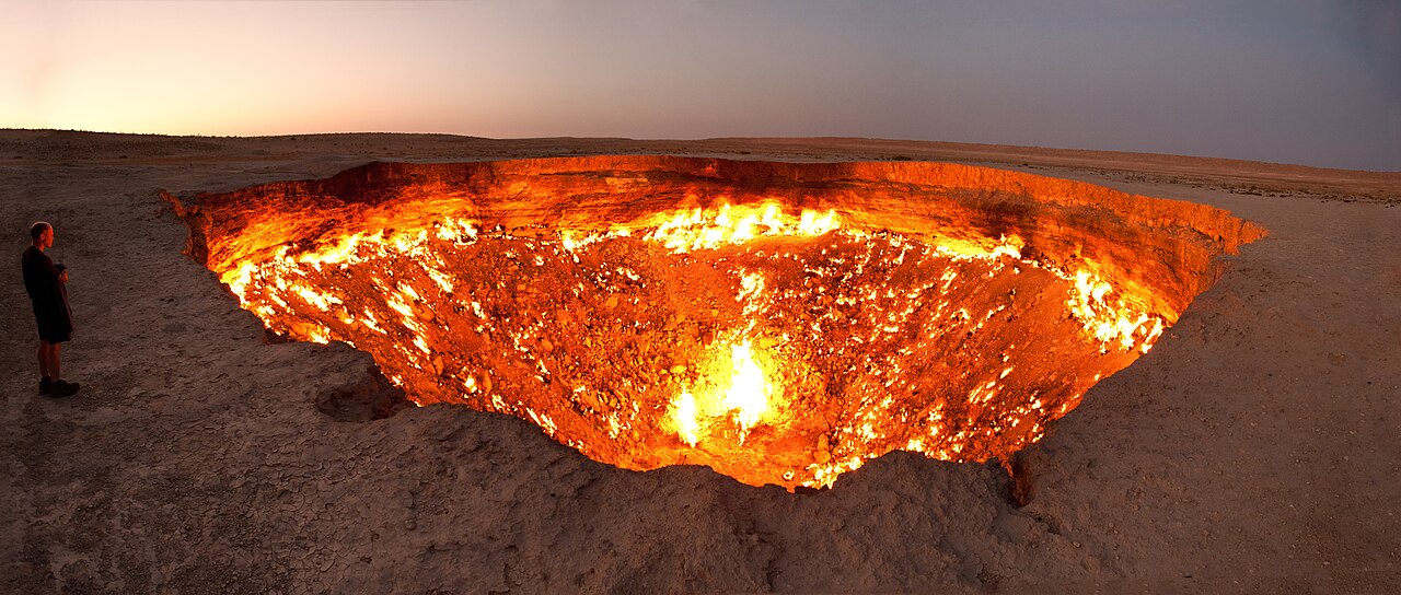
- No. It is a gas crater. The widely repeated story placing its origin in a Soviet drilling accident in 1971 is not securely documented, and the strength of the flames has changed over time.
- Is all of Turkmenistan sandy desert?
- No. Mountain slopes, pistachio woodland and grassland at Badkhyz, river-fed oases and Caspian wetlands provide other habitats. They support different species and face different conservation pressures.
More about Turkmenistan: nature & wildlife
Repetek protects sandy-desert ecosystems in the eastern Karakum, where saxaul, reptiles and other species are adapted to heat and scarce water. The Cold Winter Deserts of Turan World Heritage property, inscribed in 2023, includes protected areas in Turkmenistan, Kazakhstan and Uzbekistan. Badkhyz in the south has pistachio woodland and grassland associated with kulan, a wild ass. Kopet Dag and Koytendag support different mountain habitats.
Yangykala’s coloured cliffs expose layered sedimentary rocks in western Turkmenistan. Caspian wetlands support migratory birds, while falling water levels affect coastal habitats. Water diversion, salinity, desertification and gas-related emissions are environmental challenges. Darvaza is a gas crater rather than a volcano. Its often-repeated 1971 origin story is not securely documented, and flame intensity has changed; an older photograph does not show its present condition.
Food & Cuisine of Turkmenistan
Palow, dograma, ishlekli, flatbread and food traditions shared across Central Asia.
- What is palow?
- A rice dish commonly prepared with meat and carrots, related to pilaf traditions across Central Asia. Recipes vary by region, household and occasion.
- How do dograma and ishlekli differ?
- Dograma combines pieces of bread, cooked meat and onions, often with broth. Ishlekli is a filled pie, commonly made with meat and onions. Neither is simply another name for rice pilaf.
- What is çal?
- A fermented camel-milk drink. It is a dairy product, so travellers with allergies or dietary restrictions should check ingredients and preparation directly rather than relying on translated dish names.
More about Turkmenistan: food & cuisine
Palow is a rice dish commonly made with meat and carrots, related to pilaf traditions across Central Asia. Dograma combines torn or shredded bread with cooked meat and onions, often served with broth. Ishlekli is a filled pie, commonly containing meat and onions. Çörek is bread, often baked in a tamdyr oven. Recipes and names vary among households and regions; there is no single menu eaten by everyone.
Soups, dumplings, dairy foods and seasonal produce also feature. Çal is fermented camel milk, while tea is widely served. Turkmen melons have a celebrated place in food culture, but they include multiple varieties rather than one exclusive type. Hospitality often involves shared food, although customs differ. Anyone with dietary needs should check ingredients directly: meat, animal fat and dairy may occur in dishes that look mainly like bread, rice or soup.
Landmarks of Turkmenistan
Merv, Kunya-Urgench and Nisa, with archaeological sites, museums and desert landscapes.
- Which three historic places have separate UNESCO listings?
- Ancient Merv, Kunya-Urgench and the Parthian Fortresses of Nisa. The Cold Winter Deserts of Turan is a separate transnational natural property with Turkmen components.
- Where is the Sultan Sanjar mausoleum?
- In ancient Merv near Bayramaly, east of the modern city of Mary. Its position in the oasis helps distinguish Merv from Nisa near Ashgabat and Kunya-Urgench in the north.
- Can I use the sight map as proof that a place is open?
- No. Pins mark learning locations. Official advice describes visa support, registration and restricted areas; check current entry rules, permissions and local access with the responsible authorities or an authorised operator.
More about Turkmenistan: landmarks
Ancient Merv, Kunya-Urgench and the Parthian Fortresses of Nisa are separate UNESCO World Heritage properties. Merv’s Sultan Sanjar mausoleum and Greater Kyz Kala belong to a large archaeological oasis east of Mary. Kunya-Urgench’s monuments include the Kutlug-Timur minaret and Turabek-Khanum complex. Old Nisa stands near Bagyr west of Ashgabat; it is not another name for Merv. Gonur Depe reaches farther back into Bronze Age Margiana.
Ashgabat’s National Museum and Carpet Museum offer complementary introductions to archaeology and craft. Yangykala, the Caspian coast, Kow Ata cave lake and Koytendag’s dinosaur footprints broaden the picture beyond the capital. The sight map marks learning locations, including landscape references. Official entry advice describes visa support, registration and restricted areas; access should be confirmed with the responsible authorities or an authorised operator before planning a visit.
People & Society of Turkmenistan
Turkmen, Uzbek, Russian, Kazakh and other communities, and connections beyond state borders.
- Do the five flag motifs describe every Turkmen identity?
- No. They refer to five major historical tribal traditions. Tribal affiliations are more varied, and the population also includes Uzbek, Russian, Kazakh and other communities.
- Who was Magtymguly Pyragy?
- An eighteenth-century poet widely celebrated in Turkmen literature. His writing addresses moral life, personal loss and community, and remains important to national cultural memory.
- Who won independent Turkmenistan’s first Olympic medal?
- Polina Guryeva won silver in women’s weightlifting at the Tokyo 2020 Olympics, which were held in 2021. It was the country’s first Olympic medal, not its first Olympic gold.
More about Turkmenistan: people & society
Turkmen form the majority, alongside Uzbek, Russian, Kazakh and other communities. Historical tribal affiliations include Teke, Yomut, Ersari, Saryk and others, but five flag motifs do not divide every person into five fixed categories. Turkmen communities also live in neighbouring countries. Pastoral mobility, oasis farming, craft production and urban trade all belong to the region’s history; describing everyone as traditionally nomadic obscures that diversity.
Magtymguly Pyragy, an eighteenth-century poet, is a major figure in Turkmen literature. His work addresses moral life, loss and community. Composer Nury Halmammedov helped shape twentieth-century concert and film music. Weightlifter Polina Guryeva won silver at the Tokyo 2020 Games, held in 2021, giving independent Turkmenistan its first Olympic medal. Family networks, education, work and migration shape modern lives alongside the national symbols most visible to visitors.