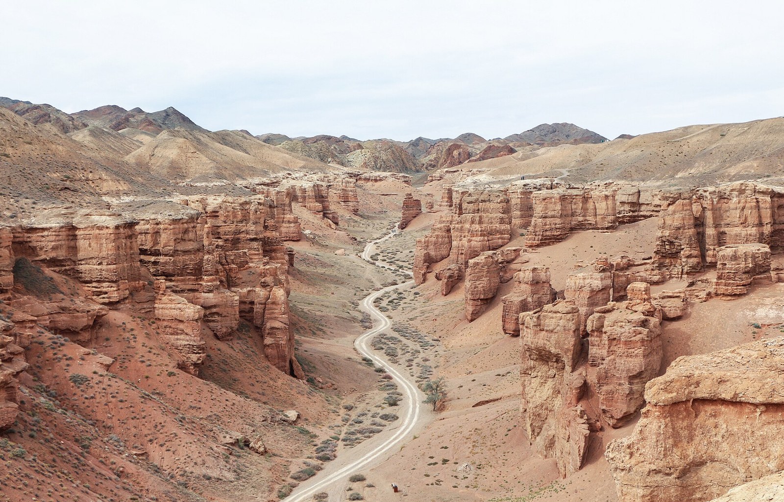
Facts about Kazakhstan
Kazakhstan stretches from the Caspian coast and open steppe to the Altai and Tian Shan. Explore Charyn Canyon’s red towers, the mountain lakes near Almaty and Turkistan’s Timurid heritage, then connect those places with the histories, languages and communities of the world’s largest landlocked country.
- Population, January 2026
- About 20.5 million
- Area
- 2,724,900 km²
- Capital
- Astana
- Currency
- Tenge (KZT)
- State language
- Kazakh
- Administrative areas
- 17 regions + 3 separate cities
Kazakhstan · 0 of 20 rounds passed
Two timed rounds per topic, 20 seconds a question
Begin with a region rather than trying to cross the whole country in one short trip. Almaty is a gateway to the southeastern mountains, Charyn Canyon and the Kolsai lakes. Astana introduces the northern steppe and the nearby lake landscapes of Akmola. Southern routes connect Shymkent, Turkistan and Taraz, while Aktau is a starting point for Mangystau’s desert plateaus.
The country guide brings together maps, fifteen sights and ten facts topics. Learn the seventeen regions and three separate cities, place regional capitals, then follow rivers and lakes. Practise Kazakh and Russian through the linked lessons. The mountains, northern plains and Caspian desert coast have different climates, so the best season depends on the places and activities you choose.
Geography of Kazakhstan
Caspian shores, open steppe and mountain borders in the world’s largest landlocked country.
- Why is Kazakhstan landlocked if it has a coast?
- The Caspian Sea has no natural outlet to the ocean. Its shoreline therefore does not make Kazakhstan an ocean-facing country.
- How many regions does Kazakhstan have?
- Seventeen regions, plus the separately administered cities of Astana, Almaty and Shymkent. Abay, Ulytau and Zhetysu were created in 2022.
- Is all of Lake Balkhash freshwater?
- No. The western basin is generally fresher than the eastern basin. The difference is associated with river inflow and limited exchange through the narrow connecting strait.
More about Kazakhstan: geography
Kazakhstan covers about 2.72 million square kilometres, making it the world’s largest landlocked country. Its Caspian coastline does not give it a natural outlet to the ocean. It borders Russia, China, Kyrgyzstan, Uzbekistan and Turkmenistan. Grassland stretches across the north, while semi-desert and desert occupy much of the centre and south. The Altai rises in the northeast and the Tian Shan along the southeastern frontier.
The Irtysh passes through Oskemen, Semey and Pavlodar before entering Russia. The Ishim crosses Astana and Petropavl, while the Ural links Oral and Atyrau with the Caspian. The Syr Darya flows through southern Kazakhstan towards the North Aral Sea. Lake Balkhash’s western basin is generally fresher than its eastern basin. Kazakhstan has seventeen regions and three separately administered cities: Astana, Almaty and Shymkent. Abay, Ulytau and Zhetysu were created in 2022. Baikonur has a distinct status under its lease to Russia.
History of Kazakhstan
Steppe societies, the Kazakh Khanate and the upheavals of Soviet rule.
- When did Kazakhstan become independent?
- On 16 December 1991, during the breakup of the Soviet Union.
- What were the three zhuz?
- Broad Kazakh tribal groupings usually called the Senior, Middle and Junior zhuz. They were not three separate modern countries.
- What was the Semipalatinsk test site?
- A major Soviet nuclear weapons testing area in northeastern Kazakhstan. Testing left lasting consequences for nearby communities and the environment.
More about Kazakhstan: history
Long before the modern state, steppe communities moved livestock across seasonal pastures and traded with settled towns. Southern cities such as Taraz and Turkistan formed part of Silk Road networks. The Kazakh Khanate emerged in the fifteenth century under Kerei and Janibek. Kazakh society developed three broad groupings called zhuz, usually rendered Senior, Middle and Junior. Russian imperial expansion gradually brought Kazakh lands under imperial rule during the eighteenth and nineteenth centuries.
Soviet collectivisation disrupted pastoral livelihoods and contributed to the devastating famine of the early 1930s. Deportations brought many communities to Kazakhstan against their will. The Virgin Lands campaign expanded northern grain cultivation in the 1950s, while the Semipalatinsk test site exposed people and landscapes to nuclear testing. Kazakhstan declared independence on 16 December 1991. Almaty remained the capital until the government moved north in 1997 to the city then called Akmola, which was renamed Astana in 1998.
Kazakh language
A Turkic language, a continuing Cyrillic tradition and everyday Russian.
- Are Kazakh and Russian related?
- They belong to different language families. Kazakh is Turkic, while Russian is an Indo-European language in the Slavic branch.
- Has Kazakh completely changed to Latin script?
- No. Latin-script reform has been proposed and revised, while Cyrillic remains widely used. The linked Kazakh lessons use Cyrillic with pronunciation guidance.
- How do you say thank you in Kazakh?
- Рақмет, written raqmet in this pronunciation guide. Сәлем, or sälem, is an informal hello.
More about Kazakhstan: language
Kazakh belongs to the Kipchak branch of the Turkic family, alongside languages such as Karakalpak and Nogai. It adds suffixes to words to express grammatical relationships, and vowel harmony influences many endings. Russian belongs to the Slavic branch of the Indo-European family. Kazakh is the state language. Under the 2026 constitution, Russian is officially used alongside Kazakh in state organisations and local self-government bodies.
Kazakh has used Arabic, Latin and Cyrillic scripts at different times. A transition towards Latin script has been proposed and revised, while Cyrillic remains widely used. The linked Kazakh lessons introduce everyday phrases with Cyrillic text and pronunciation guidance. Сәлем (sälem) is an informal hello, рақмет (raqmet) means thank you and сау болыңыз (sau bolyñyz) is a polite goodbye. Russian lessons are also available. Language use varies by household, city and generation, so a single regional stereotype cannot describe every speaker.
Culture of Kazakhstan
The dombra, aitys and Nauryz carry living traditions into modern cities.
- What is a dombra?
- A traditional two-stringed, long-necked plucked instrument. Instrumental pieces called kuy are a major part of its repertoire.
- What is aitys?
- An improvised contest between poets who sing, often accompanying themselves on a dombra. It is distinct from instrumental kuy.
- What does Nauryz celebrate?
- Spring renewal around the March equinox. Shared meals and public performances are common, while customs vary.
More about Kazakhstan: culture
The dombra is a long-necked, two-stringed plucked instrument. A kuy is an instrumental piece whose performance can tell a story through rhythm and melody. Aitys is an improvised contest between poets who sing and accompany themselves. UNESCO recognises Kazakh dombra kuy and the shared aitysh or aitys tradition. Abai Qunanbaiuly’s poetry and prose remain central to Kazakh literary life, while contemporary music, theatre and film draw on many influences.
Nauryz celebrates spring renewal around the March equinox. Shared meals and public performances mark the holiday, with customs varying between families and places. Yurt making, felt work and equestrian traditions reflect pastoral history. Kokpar is a mounted team contest, while eagle hunting has a long tradition in parts of the steppe and mountain world. These practices form part of a modern society where most people live in towns and cities, rather than describing how every Kazakhstani lives.
Economy of Kazakhstan
Oil, uranium and northern grain fields meet long-distance trade routes.
- What currency does Kazakhstan use?
- The tenge, abbreviated KZT. It was introduced in 1993.
- What does Kazakhstan produce?
- Oil, uranium, copper and other mineral resources are important, alongside grain farming and a large services economy.
- Where is Baikonur?
- In Kazakhstan, near the Syr Darya. The city and cosmodrome have special arrangements under a lease to Russia.
More about Kazakhstan: economy
Oil and gas production is important around the Caspian, with major fields including Tengiz and offshore Kashagan. Kazakhstan is a leading uranium producer and also mines copper, coal and other minerals. Northern farming areas grow wheat and other grains. Industry is concentrated in several cities, including Karaganda, Pavlodar, Oskemen and Zhezkazgan. Services, finance and technology are especially visible in Almaty and Astana.
The currency is the tenge, abbreviated KZT, introduced in 1993. Railways, pipelines and ports connect places separated by vast distances. Aktau and Kuryk support Caspian freight routes, and overland corridors link China with Central Asia and Europe. Baikonur is a Kazakhstani space-launch complex leased to Russia. Resource dependence, water availability and the development of a broader economy remain important policy questions.
Government of Kazakhstan
A presidential republic with a new constitutional framework from July 2026.
- What changed under the 2026 constitution?
- It took effect on 1 July 2026, replacing the former bicameral parliament with the unicameral Kurultai and introducing a vice-presidency.
- How many deputies are in the Kurultai?
- 145. They are elected for five-year terms under a proportional party-list system.
- Is Astana part of Akmola Region?
- It is surrounded by Akmola’s geographical setting but is administered separately. Kokshetau is Akmola’s regional capital.
More about Kazakhstan: politics
Kazakhstan is a unitary presidential republic, with Astana as its political centre. A new constitution approved in the March 2026 referendum entered into force on 1 July 2026. It replaced the former two-chamber parliament with a single-chamber legislature called the Kurultai and introduced a vice-presidency. The Kurultai has 145 deputies elected for five-year terms under a proportional party-list system. Executive power remains central to the political system.
The president is head of state and the government is headed by a prime minister. Regional and local administration includes akims, or heads of administration. Nursultan Nazarbayev led the country until 2019, when Kassym-Jomart Tokayev became president. Constitutional rules and the way political power operates are different questions: OSCE election observers have continued to raise concerns about meaningful political competition and fundamental freedoms. The country maintains relationships with Russia, China and Western states, alongside its Central Asian neighbours.
Nature and wildlife in Kazakhstan
Saiga steppe, migratory wetlands and wild apple forests below the mountains.
- What is the saiga?
- An antelope adapted to steppe and semi-desert, recognised by its flexible, bulbous nose. Its population has recovered substantially after earlier declines.
- Why are Kazakhstan’s wild apple forests important?
- They contain Malus sieversii, an important ancestor of cultivated apples. The forests also support mountain biodiversity.
- Has the whole Aral Sea recovered?
- No. The North Aral Sea has seen partial recovery following the Kok-Aral dam. The wider sea system remains heavily damaged after large-scale river diversions.
More about Kazakhstan: nature & wildlife
Saiga antelope are adapted to open grassland and semi-desert, with a distinctive flexible nose. Their numbers have recovered substantially after severe declines, although habitat pressures, disease and conflict over land use remain concerns. Snow leopards inhabit mountain landscapes, and wild apple forests in the Tian Shan include Malus sieversii, an important ancestor of cultivated apples. The Caspian seal lives in the inland Caspian system.
The Saryarka World Heritage property includes the Korgalzhyn and Naurzum reserves, protecting steppe and wetlands important to migratory birds. Aksu-Zhabagly forms part of the transboundary Western Tien-Shan property. Charyn Canyon, Altyn-Emel and the Kolsai lakes show very different landscapes within the southeast. The Aral Sea’s contraction followed large-scale diversion of rivers for irrigation. The North Aral Sea has seen partial recovery after the Kok-Aral dam, while the wider environmental damage remains extensive.
Food in Kazakhstan
Shared meat and noodle dishes, fried baursak and fermented dairy.
- What is beshbarmak?
- A shared dish of boiled meat and broad noodles, often with onions and broth. Ingredients and serving customs vary.
- What is qymyz?
- Fermented mare’s milk, often called kumis in English. Shubat is a different fermented drink made from camel’s milk.
- What are baursak and qurt?
- Baursak are small pieces of fried dough. Qurt, also written kurt, is a dried dairy food that may be shaped into small balls.
More about Kazakhstan: food & cuisine
Beshbarmak combines boiled meat with broad noodles, often served with broth and onions. Horsemeat, mutton and beef may appear in different versions, and serving customs vary by gathering and region. Kazy is a sausage traditionally made with horsemeat. Baursak are small pieces of fried dough served at many shared meals. Qurt, also written kurt, is a dried dairy food that can be shaped into small balls.
Qymyz, often called kumis in English, is fermented mare’s milk. Shubat is made from fermented camel’s milk. Tea is widely offered to guests, often with milk and something to eat. Kazakhstan’s food also reflects the traditions of communities across Central Asia and beyond. Plov, lagman and manty are familiar dishes, while urban restaurants offer many other cuisines. Dietary choices differ between people, so pastoral dishes are a starting point for learning rather than a description of every meal.
Landmarks of Kazakhstan
Turkistan’s Timurid dome, Tanbaly’s rock art and Astana’s planned skyline.
- Who commissioned the Yasawi mausoleum?
- Timur commissioned it in the late fourteenth century in Turkistan. It remained unfinished after his death in 1405.
- Are Tanbaly and Tamgaly-Tas the same place?
- No. Tanbaly is the UNESCO petroglyph landscape in the Chu-Ili hills. Tamgaly-Tas is a separate rock-carving site beside the Ili River.
- How did Lake Kaindy form?
- A landslide triggered by the 1911 earthquake blocked a gorge. Water then submerged the spruce forest, leaving trunks rising above the lake.
More about Kazakhstan: landmarks
The Mausoleum of Khoja Ahmed Yasawi in Turkistan was commissioned by Timur in the late fourteenth century and remained unfinished after his death in 1405. Its monumental halls and tiled dome are part of a UNESCO World Heritage site. Tanbaly, often written Tamgaly, contains a large concentration of petroglyphs, including Bronze Age carvings. It is distinct from Tamgaly-Tas, the rock-carving site beside the Ili River.
Astana’s Baiterek Tower represents a tree crowned by a golden sphere. Khan Shatyr is a large tent-shaped entertainment centre, and the Palace of Peace and Reconciliation is a pyramid designed by Foster + Partners. Almaty’s Ascension Cathedral is a notable wooden building that survived the 1911 earthquake. Beyond the cities, the sights section connects these monuments with Charyn Canyon, the Kolsai lakes, Lake Kaindy and the chalk formations of Bozzhyra in Mangystau.
People of Kazakhstan
A diverse population shaped by migration, deportation and changing cities.
- Does Kazakhstani mean the same thing as ethnic Kazakh?
- Kazakhstani can refer to citizenship or a connection with the country. Kazakh can describe an ethnic identity or the language.
- Who are the Koryo-saram?
- Ethnic Koreans of the former Soviet Union. Many families in Kazakhstan descend from people deported from the Soviet Far East.
- Who was the first ethnic Kazakh in space?
- Toktar Aubakirov, who flew in 1991. Talgat Musabayev and Aidyn Aimbetov are other Kazakh cosmonauts.
More about Kazakhstan: people & society
Kazakhstan’s population was about 20.5 million at the start of 2026, according to the national statistics bureau. Ethnic Kazakhs form the majority and ethnic Russians the largest minority. Uzbek, Ukrainian, Uyghur, German and Korean communities are among the many others. The term Kazakh describes an ethnic identity or the language, while Kazakhstani can refer to citizenship or a connection with the country. Individual identities can include several languages and traditions.
Population history includes migration, imperial settlement and Soviet forced deportations. The Koryo-saram are ethnic Koreans of the former Soviet Union, many descended from people deported from the Soviet Far East. Qandas refers to ethnic Kazakhs who have returned from abroad. Most residents now live in urban areas, but rural livelihoods remain important. Notable figures include the writer Abai, cosmonaut Toktar Aubakirov, boxer Gennady Golovkin and Olympic figure skater Denis Ten.