Facts about North Korea
Explore North Korea from the volcanic heights of Paektu to the granite valleys of Kumgang, the Taedong River and the old capital of Kaesong. Connect its regions, cities and waters with Korean history, food and everyday language. Its cultural heritage belongs to a much longer history than the state established in 1948.
- Capital
- Pyongyang
- Population
- About 26.6 million, 2025 UN estimate
- Area
- 120,538 km²
- Currency
- North Korean won (KPW)
- Official language
- Korean
- World Heritage sites
- 3, including Kumgang since 2025
North Korea · 0 of 20 rounds passed
Two timed rounds per topic, 20 seconds a question
North Korea occupies the northern Korean Peninsula between China, Russia and South Korea. Mountain ranges dominate the interior, while the western plains contain much of its farmland and several major cities. Pyongyang stands on the Taedong, Sinuiju faces China across the Yalu, and Hamhung and Chongjin are important eastern industrial centres. Nine provinces sit alongside four cities with province-level status: Pyongyang, Nampo, Rason and Kaesong.
Ancient tomb paintings, Koryo monuments and Buddhist mountain landscapes connect the country with the shared history of Korea. Contemporary life is shaped by an authoritarian state, restrictions on movement and information, and unequal access to resources. Independent reporting is limited. The photographs and places in this guide help explain geography and heritage, while current official travel advice is essential for anyone considering a visit.
Geography of North Korea
North Korea has a west coast on the Yellow Sea and an east coast on the Sea of Japan, called the East Sea in Korean usage. The Yalu, also called Amnok, and Tumen rivers form much of the northern frontier. The short Russian border lies near the Tumen’s mouth. The southern boundary follows the Military Demarcation Line within the Demilitarized Zone, rather than simply tracing the 38th parallel.
- Which countries border North Korea?
- China, Russia and South Korea. The Yalu and Tumen form much of the northern frontier, while the southern boundary lies within the DMZ.
- Are Pyongyang, Nampo, Rason and Kaesong provinces?
- They are cities with province-level administrative status, alongside nine provinces. Their administrative territories extend beyond the urban centres marked on the city map.
- Which river passes through Pyongyang?
- The Taedong. It flows through the capital and reaches the western coast near Nampo.
More about North Korea: geography
The northern highlands include Paektu, a volcano shared with China whose caldera holds Heaven Lake. Ryanggang surrounds Hyesan on the upper Yalu, while Chagang lies farther west around Kanggye. The Hamgyong provinces extend along the east, and the Hwanghae provinces occupy the southwest. Kangwon contains Wonsan and the Kumgang Mountains.
Pyongyang is a separate capital-level unit. Nampo lies downstream near the Taedong estuary, Rason occupies the northeastern corner, and Kaesong stands near the southern boundary. These city-level regions contain more than the built-up centres shown as dots on the city map. English spellings vary between sources, including Pyongan and Phyongan, Hamgyong and Hamgyŏng.
History of North Korea
Goguryeo, also written Koguryo, was an ancient kingdom extending across northern Korea and parts of northeastern China. Its later capital was Pyongyang, and surviving tomb murals record clothing, religious imagery and aspects of elite life. Kaesong became the capital of the later Koryo, or Goryeo, dynasty, which ruled from 918 to 1392 and gave Korea its English name.
- Was Kaesong always part of North Korea?
- No. After the 1945 division it was on the southern side. The Korean War and the 1953 armistice left it under northern control.
- What is the difference between Goguryeo and Koryo?
- Goguryeo, also written Koguryo, was an ancient kingdom whose later capital was Pyongyang. Koryo, or Goryeo, was a later dynasty, ruling from 918 to 1392 with its capital at Kaesong.
- Did the Korean War end with a peace treaty?
- No. An armistice signed on 27 July 1953 stopped the fighting without establishing a final peace settlement.
More about North Korea: history
Japan annexed Korea in 1910 and ruled the peninsula until 1945. At the end of the Second World War, Soviet and American occupation zones were divided at the 38th parallel. Separate governments were established in 1948. North Korean forces invaded South Korea in June 1950, beginning a war that involved a US-led UN Command on the southern side and Chinese forces on the northern side.
The armistice of 27 July 1953 stopped the fighting without providing a final peace settlement. Its line left Kaesong under northern control and created the DMZ. Reconstruction transformed Pyongyang, which had suffered extensive wartime destruction. The later state developed under Kim Il Sung, followed by Kim Jong Il and then Kim Jong Un, while division kept many families apart.
Language of North Korea
Korean is the official language. North and South Korea share the same language, although regional accents and decades of separate language policy have produced differences in vocabulary, pronunciation and spelling. North Korea calls its standard Munhwaŏ, often translated as cultured language, and associates it with Pyongyang.
- Do North and South Korea speak unrelated languages?
- No. Both speak Korean. Their standards differ in some pronunciation, spelling and vocabulary, alongside regional dialect differences.
- What is Chosongul?
- The name commonly used in North Korea for the Korean alphabet, generally called Hangul in South Korea. Letters combine into syllable blocks.
- Do the linked Korean lessons teach only northern usage?
- No. They introduce general Korean phrases and largely South Korean standard usage. Northern vocabulary and local social conventions need additional study.
More about North Korea: language
The Korean alphabet was developed in the fifteenth century. Its letters are arranged into syllable blocks. It is commonly called Chosongul in the North and Hangul in the South. Place names can look quite different in Latin letters: Kaesong and Gaeseong, or Nampo and Nampho, can refer to the same places rather than different towns.
Honorifics and speech levels express social relationships. Worldly’s linked Korean lessons introduce general Korean phrases and largely South Korean standard usage. They offer an introduction to the shared language, while northern vocabulary and local conventions need additional study. A phrase learned in one standard should not be assumed to fit every social setting.
Culture of North Korea
Arirang is a family of Korean folk songs with regional versions and associations with longing, separation and shared identity. UNESCO inscribed the North Korean tradition in 2014, following a separate South Korean inscription in 2012. The folk song tradition is distinct from the large state-organised mass performances that have also used the name Arirang.
- Is Arirang only the name of a mass performance?
- No. Arirang is a Korean folk song tradition with many regional versions. The state-organised mass performances that used that name are a separate cultural expression.
- What are ssirum and ssireum?
- North and South Korean names for a traditional form of wrestling in which competitors grip a cloth belt. The two Koreas share a joint UNESCO inscription from 2018.
- Do public performances show the whole of private life?
- No. Public performances are tightly directed by the state. They express official narratives, while households and communities have experiences that cannot be inferred from a stadium display.
More about North Korea: culture
Traditional wrestling is called ssirum in North Korean usage and ssireum in the South. Competitors grip a cloth belt and try to bring their opponent to the ground. A joint UNESCO inscription in 2018 recognises the tradition across both Koreas. Seasonal food preparation, family customs and traditional clothing also connect communities with older Korean cultural practices.
Public art, film and organised performances operate under state control. Choreographed stadium displays and monumental architecture communicate official political narratives. They cannot stand in for every household’s experience or private beliefs. Historic Buddhist sites survive, while contemporary freedom of religion and expression is severely restricted.
Economy of North Korea
The economy combines extensive state direction with market activity that became important to household survival after the famine of the 1990s. Markets are often called jangmadang. Their presence does not mean unrestricted private enterprise: rules, enforcement and access to goods can change, and reliable national economic data remain scarce.
- What are jangmadang?
- Markets associated with household trade and livelihoods. They became important after the 1990s famine, but their activity remains subject to state rules and enforcement.
- How do Sinuiju, Nampo and Rason connect with trade?
- Sinuiju faces China across the Yalu. Nampo serves the western coast near the Taedong estuary. Rason includes the northeastern port of Rajin.
- Why should North Korean GDP figures be read cautiously?
- Reliable national data are scarce, so outside organisations produce estimates. An estimate of total output does not directly measure household access to food or other necessities.
More about North Korea: economy
Coal and mineral extraction, manufacturing and agriculture are important sectors. Hamhung and Chongjin have major industrial histories. Sinuiju connects with China across the Yalu, Nampo serves the western coast, and Rajin’s port forms part of Rason. Rice cultivation is concentrated in lower, warmer areas, while maize and other crops are important elsewhere.
Sanctions connected with nuclear and missile programmes restrict many forms of international trade. Food insecurity also reflects domestic policies, resource allocation, agricultural limitations and exposure to floods and drought. External GDP estimates should be treated as estimates, rather than precise measurements of household living standards. The currency is the North Korean won.
Politics of North Korea
The official name is the Democratic People’s Republic of Korea, usually shortened to DPRK. Despite that name, its political system is authoritarian, dominated by the Workers’ Party of Korea and the Kim family. National institutions include the Supreme People’s Assembly and the Cabinet, but their existence does not provide competitive multiparty government.
- What does DPRK stand for?
- Democratic People’s Republic of Korea, North Korea’s official name. Despite that name, the country has an authoritarian political system dominated by the Workers’ Party of Korea.
- Does Juche mean that North Korea has no foreign trade?
- No. Juche is an official ideology commonly associated with self-reliance. Political doctrine does not demonstrate economic independence from other countries.
- What is songbun?
- A social classification system based on perceived political loyalty and family background. It can affect residence, education and employment opportunities, alongside other forms of privilege.
More about North Korea: politics
Juche is an official ideology commonly described through self-reliance. It should be understood as the state’s political doctrine, rather than evidence that the economy has no external dependence. The military and nuclear programme occupy an important place in policy. North Korea and South Korea joined the United Nations on the same day in September 1991.
UN human rights investigations document arbitrary detention, forced labour and severe restrictions on movement and outside information. Residence, education and employment opportunities can be affected by the songbun social classification system and other forms of political privilege. These constraints also limit independent knowledge of life inside the country.
Nature of North Korea
Paektu’s volcanic highlands contain forests and a summit lake on the Chinese border. UNESCO’s Mount Paektu Biosphere Reserve adjoins China’s Changbaishan reserve. The mountain’s ecology differs sharply from the cultivated western lowlands and the warmer coastal areas.
- Is Paektu entirely inside North Korea?
- No. The volcanic mountain and its summit lake are shared with China, where the mountain is known as Changbai.
- Why is Kumgang a mixed World Heritage property?
- Its 2025 inscription recognises both cultural and natural significance, combining Korean mountain Buddhist heritage with exceptional granite scenery, forests and waterfalls.
- Why do Mundok and Rason matter to migratory birds?
- Their wetlands provide feeding and resting habitat along the East Asian–Australasian Flyway. They are internationally recognised migratory bird reserves.
More about North Korea: nature & wildlife
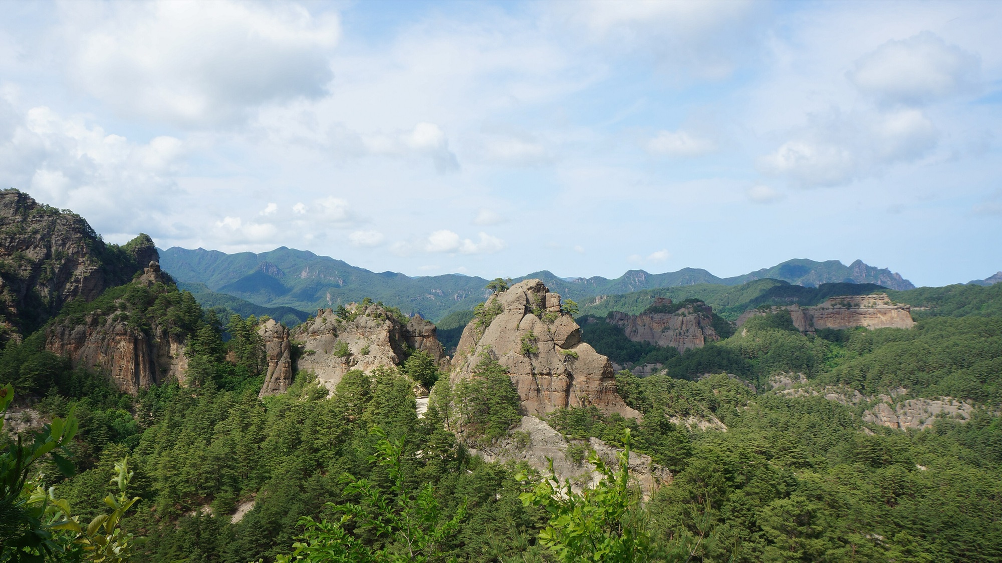
Kumgang is known for pale granite peaks, wooded valleys and waterfalls, with Buddhist sites woven into the mountain landscape. It became a UNESCO World Heritage property in 2025 under both cultural and natural criteria. Myohyang and Chilbo are also UNESCO biosphere reserves, with forest and mountain habitats worth distinguishing from a single image of the country.
Coastal wetlands form feeding and resting places along the East Asian–Australasian Flyway. Mundok, near the Chongchon estuary, and Rason have internationally recognised migratory bird reserves. Forest loss, erosion and flooding are environmental concerns, but habitat quality and conservation conditions vary by region. Limited access makes sweeping national wildlife claims difficult to verify.
Food of North Korea
Pyongyang raengmyon, usually written naengmyeon in South Korean romanization, is a cold noodle dish made primarily from buckwheat. Noodles are served with chilled broth and toppings that can include meat, vegetables and kimchi. The associated social custom entered UNESCO’s intangible heritage list in 2022.
- What is Pyongyang raengmyon?
- Cold noodles made primarily from buckwheat, served with chilled broth and toppings. Naengmyeon is the more familiar South Korean romanization.
- What is recognised by the kimchi-making heritage inscription?
- The shared knowledge and social practice of preparing fermented vegetables. It recognises a living tradition with regional variations, rather than prescribing one universal recipe.
- Can a famous restaurant dish describe every household’s diet?
- No. Food access varies by location, household resources and supply conditions. Regional cooking traditions need to be understood alongside recurring food insecurity.
More about North Korea: food & cuisine
Kimchi is fermented seasoned vegetables, with ingredients and preparation varying by place and season. UNESCO inscribed the North Korean kimchi-making tradition in 2015. Rice, maize, noodles, soups and preserved vegetables feature in regional foodways. Kaesong has its own culinary traditions, while the eastern coasts connect cooking with seafood.
A restaurant photograph or celebrated national dish does not describe what every family can eat. Food availability varies with household resources, location and supply conditions. The famine of the 1990s and recurring food insecurity are essential context, while precise claims about current diets require evidence that is often unavailable.
Landmarks of North Korea
The Complex of Koguryo Tombs became North Korea’s first UNESCO World Heritage property in 2004. It contains 63 tombs, including 16 with wall paintings, around Pyongyang and nearby areas. The murals provide evidence of the kingdom’s artistic traditions and the lives represented by its burial culture.
- What do the Koguryo tomb murals preserve?
- Images of clothing, religious motifs and aspects of elite life from the ancient kingdom. The inscribed property contains 63 tombs, including 16 with wall paintings.
- Which dynasty is associated with Kaesong’s World Heritage monuments?
- The Koryo, or Goryeo, dynasty. Its former capital contains palace remains, institutions, tombs and defensive structures recognised by UNESCO in 2013.
- Does UNESCO listing guarantee that a place can be visited?
- No. Listing recognises heritage significance. Visitor access, permissions, routes and consular support must be checked separately against current official travel advice.
More about North Korea: landmarks
Kaesong’s Historic Monuments and Sites were inscribed in 2013. Twelve components include palace remains, educational institutions, tombs and defensive structures associated with the Koryo dynasty. Kumgang’s 2025 inscription added a third World Heritage property, bringing ancient Buddhist sites together with a striking mountain landscape.
Pyongyang’s Juche Tower, assembly buildings and broad avenues belong to a very different period and communicate the modern state’s own narratives. UNESCO recognition describes heritage significance rather than present visitor access. Travel arrangements, permission to visit places and consular support remain highly restricted and can change.
People of North Korea
The UN estimated North Korea’s population at about 26.6 million in 2025. Most residents are ethnically Korean. Pyongyang is the largest city, but eastern industrial centres, western farming areas and northern border towns have different histories and living conditions.
- How many people live in North Korea?
- About 26.6 million according to the UN’s 2025 estimate. This is a dated estimate, rather than a live population count.
- Why can Pyongyang give an incomplete picture of the country?
- The capital has different access to resources and residence rules. Its curated visitor routes do not represent life in farming communities, border towns or other industrial cities.
- How has division affected Korean families?
- Division and war separated relatives across a border that ordinary people cannot freely cross. Family separation remains a human consequence of the political conflict.
More about North Korea: people & society
Families, school, work and neighbourhood organisations structure everyday life within a tightly controlled political system. Access to the capital and to desirable housing or employment is unequal. Household markets and personal networks also affect how people obtain necessities. Neither official publicity nor a single account from outside can represent all communities.
The division of Korea and the war separated families across a border that ordinary people cannot freely cross. People who leave North Korea describe varied backgrounds and experiences, and their accounts need context rather than being treated as interchangeable. Understanding the country means keeping its residents visible alongside institutions, monuments and geopolitical conflict.