Facts about Haiti
Explore Haiti from the northern coast and the Citadelle to the Artibonite Valley, Port-au-Prince and the southern peninsula. Ten illustrated topics connect the country’s landscapes with its revolutionary history, Kreyòl, food, arts and communities.
- Capital
- Port-au-Prince
- Official languages
- Haitian Creole and French
- Currency
- Haitian gourde (HTG)
- Departments
- 10
- Highest point
- Pic la Selle, about 2,680 m
- Independence
- 1 January 1804
Haiti · 0 of 20 rounds passed
Two timed rounds per topic, 20 seconds a question
Haiti occupies western Hispaniola and includes offshore islands such as La Gonâve, Île de la Tortue and Île-à-Vache. Port-au-Prince faces the Gulf of Gonâve; Cap-Haïtien and Fort-Liberté lie on the northern coast. Gonaïves and Saint-Marc connect with the Artibonite region, while Hinche lies on the central plateau.
Jacmel faces the southern Caribbean coast; Les Cayes, Jérémie and Miragoâne connect different parts of the southern peninsula. The map introduces twelve settlement centres, and landmark pins locate historic places and landscapes. These are learning locations rather than travel routes. Read the linked current travel advice before considering a visit.
Geography of Haiti
Mountains, coastal plains and offshore islands in the western part of Hispaniola.
- Which island do Haiti and the Dominican Republic share?
- Hispaniola, in the Greater Antilles. Haiti occupies its western portion.
- What is Haiti’s highest mountain?
- Pic la Selle, about 2,680 metres above sea level, in the Massif de la Selle.
- Where does the Artibonite River flow?
- From the Dominican Republic through central Haiti to the Gulf of Gonâve. Its valley is an important farming area.
More about Haiti: geography
Haiti occupies the western part of Hispaniola in the Greater Antilles. The Dominican Republic is its only land neighbour; Cuba lies across the Windward Passage to the northwest and Jamaica across the Caribbean Sea to the southwest. Haiti also includes offshore islands, notably La Gonâve, Île de la Tortue and Île-à-Vache. Port-au-Prince, the capital, stands beside the Gulf of Gonâve, while Cap-Haïtien faces the Atlantic on the northern coast.
Mountain ranges divide the country into valleys, plateaus and coastal plains. The Massif de la Selle in the south contains Pic la Selle, the highest summit at about 2,680 metres. The Artibonite River rises in the Dominican Republic and crosses central Haiti to the Gulf of Gonâve, supporting an important agricultural valley. Ten departments are administrative divisions; the city map instead marks settlement centres, from Port-de-Paix and Fort-Liberté to Jacmel and Jérémie.
History of Haiti
A revolution against slavery and colonial rule led to independence on 1 January 1804.
- When did Haiti declare independence?
- On 1 January 1804, at Gonaïves, after the revolution against slavery and French colonial rule.
- Did Toussaint Louverture proclaim independence?
- No. He was a central revolutionary leader but died in French captivity in 1803. Jean-Jacques Dessalines proclaimed independence in 1804.
- When did the United States occupy Haiti?
- From 1915 to 1934. The occupation affected government, finance and infrastructure and met Haitian resistance.
More about Haiti: history
Taíno communities lived on Hispaniola before European colonisation. Spanish conquest brought forced labour, disease and profound disruption. France established control over the western colony of Saint-Domingue, recognised by Spain in 1697. Sugar and coffee plantations depended on the brutal exploitation of enslaved Africans. The uprising that began in 1791 developed into a revolution involving shifting alliances and leaders including Toussaint Louverture, Jean-Jacques Dessalines and Henri Christophe.
On 1 January 1804, Dessalines proclaimed independence at Gonaïves. Haiti became the first independent Black republic and the first modern state founded through a successful revolt by enslaved people. France later demanded an indemnity in return for recognition in 1825, creating a heavy financial burden. The United States occupied Haiti from 1915 to 1934. The Duvalier dictatorships lasted from 1957 to 1986, followed by difficult struggles over democracy, institutions and sovereignty.
Haitian Creole and French
Kreyòl and French are official languages, with different roles in everyday life and institutions.
- What are Haiti’s official languages?
- Haitian Creole and French. Kreyòl is the main shared language of everyday life.
- Is Haitian Creole a variety of French?
- No. It is a distinct language with its own grammar and writing conventions, despite much French-derived vocabulary.
- Which language do the linked lessons teach?
- Haitian Creole, also called Kreyòl ayisyen. French is discussed in the reading but is a separate language.
More about Haiti: language
Haitian Creole, called Kreyòl ayisyen, and French are Haiti’s official languages under the 1987 constitution. Kreyòl is the shared language of everyday life for the great majority of Haitians. Much of its vocabulary has French origins, but it has its own grammar, pronunciation and writing conventions. It is a language in its own right, not incorrect French. African languages and the multilingual colonial Caribbean helped shape its development.
French remains influential in parts of education, government, law and publishing, but fluency and access are unequal. Teaching, public information and literature in Kreyòl matter for participation and learning. Writers and broadcasters work in both languages, while migration adds English, Spanish and other languages to many families’ lives. The linked Worldly lessons introduce Haitian Creole greetings, food, numbers and everyday situations; they do not require prior knowledge of French.
Culture of Haiti
Painting, metalwork, Vodou, konpa and carnival carry different strands of Haitian creativity.
- What craft is Croix-des-Bouquets known for?
- Cut and hammered metalwork, often made from recycled steel drums.
- What is konpa?
- A Haitian dance-music tradition associated with bandleader Nemours Jean-Baptiste and the 1950s.
- Why is Jacmel a UNESCO Creative City?
- For crafts and folk art, including papier-mâché, masks and carnival traditions. This is a different designation from World Heritage status.
More about Haiti: culture
Haitian visual arts include painting, sculpture, beadwork, textiles and cut metal. Artists in Croix-des-Bouquets are known for turning sheet metal, including recycled drums, into intricate works. The Centre d’Art, founded in Port-au-Prince in 1944, helped support artists and bring Haitian painting to wider audiences. Jacmel is associated with papier-mâché masks, carnival craft and a historic townscape; UNESCO recognises it as a Creative City of Crafts and Folk Art.
Konpa is a dance-music tradition associated with Nemours Jean-Baptiste and the 1950s. Rara brings processional music into public space, especially around the Easter season. Carnival celebrations have local styles, including Jacmel’s masks and performance. Vodou is a religion shaped by African spiritual traditions and Haitian history, with diverse practices and relationships to Christianity. Sensational stereotypes and fixed claims about how many people practise it obscure that complexity.
Economy of Haiti
Farming, trading, garment production and remittances support households amid major disruptions.
- What currency does Haiti use?
- The Haitian gourde, abbreviated HTG.
- Why are remittances important?
- Transfers from relatives abroad help households meet costs such as food, education, housing and health care.
- What is vetiver grown for?
- Its roots produce an aromatic oil used in perfumery. Southern Haiti is associated with this industry.
More about Haiti: economy
Haitian livelihoods connect small farms, markets, transport, services and manufacturing. Rice farming is important in the Artibonite Valley; other crops include maize, beans, plantains, mangoes and coffee. Vetiver roots are processed for an aromatic oil used in perfumery, with production associated with the south. Garment assembly links factories to overseas buyers. Informal commerce and work outside salaried employment support many households, including women who move goods between rural producers and urban markets.
The national currency is the Haitian gourde, code HTG. Money sent by relatives abroad is an important source of household support. Insecurity, displacement and interruptions to roads and ports affect jobs, food distribution, schools and health services. Earthquakes and hurricanes have also damaged homes and productive infrastructure. These pressures do not define every community in the same way; learning about the economy means recognising local enterprise as well as barriers to reliable services and opportunity.
Politics of Haiti
The constitutional framework and the functioning of institutions during crises must be distinguished.
- What are Haiti’s two parliamentary chambers?
- The Chamber of Deputies and the Senate, under the constitutional framework.
- Does the constitution describe every current transition arrangement?
- No. Constitutional design and the operation of institutions during political crises must be distinguished.
- Is Haiti a member of CARICOM?
- Yes. Haiti is also a member of the United Nations and the Organization of American States.
More about Haiti: politics
Haiti’s 1987 constitution provides for a president, a prime minister and a bicameral legislature consisting of the Chamber of Deputies and the Senate. It also recognises Haitian Creole and French as official languages and divides national administration into departments. Constitutional rules describe a framework, rather than proving that each office is filled or that elections and public services function normally at a given moment.
Political violence, interrupted elections, disputed authority and weak public institutions have repeatedly strained that framework. President Jovenel Moïse was assassinated in 2021; subsequent transition arrangements and international security initiatives have changed over time. This guide avoids presenting an undated transitional officeholder as a permanent fact. Haiti belongs to the United Nations, the Organization of American States and CARICOM. Current institutional developments and travel conditions should be checked with dated official reporting.
Nature & Wildlife of Haiti
Mountain forests, mangroves and reefs support distinctive wildlife and vulnerable watersheds.
- Where is Pic Macaya National Park?
- In the Massif de la Hotte in southwestern Haiti, an area important for endemic wildlife.
- What is an endemic species?
- A species naturally restricted to a particular geographic area. Some Haitian mountain amphibians have very small ranges.
- Are tree cover and primary forest the same thing?
- No. Tree cover can include plantations and other wooded land; primary forest describes a much more specific habitat and disturbance history.
More about Haiti: nature & wildlife
Haiti’s habitats include mountain pine and broadleaf forests, dry woodland, mangroves, wetlands and coral reefs. The Massif de la Hotte in the southwest is especially important for endemic amphibians: species with very small geographic ranges. Pic Macaya National Park protects part of this mountain landscape. La Visite National Park lies in the Massif de la Selle, south of Port-au-Prince, and includes high-elevation forest and pine habitat.
Land clearance, fuel demand, farming pressures and erosion affect forests and watersheds, but tree cover, forest cover and primary forest are different measures. A single undated percentage should not stand for all three. Hispaniola’s native mammals include the solenodon and hutia; birds such as the Hispaniolan trogon connect Haiti with the island’s wider biodiversity. Earthquakes arise from tectonic processes, while hurricanes can bring flooding and landslides. Conservation links habitat protection with secure livelihoods and watershed management.
Food & Cuisine of Haiti
Soup joumou, rice dishes, griot and pikliz connect cooking with family life and independence.
- Why is soup joumou eaten on 1 January?
- It is associated with freedom and Haiti’s independence anniversary, and is shared with families and communities.
- What is griot?
- Seasoned, marinated pork that is cooked and fried, often accompanied by plantains and pikliz.
- What gives diri djon djon its dark colour?
- Djon djon mushrooms, whose soaking or cooking liquid flavours and colours the rice.
More about Haiti: food & cuisine
Soup joumou is a squash-based soup shared especially on 1 January, Haiti’s Independence Day. Recipes often include vegetables, pasta and meat, with household variations. UNESCO inscribed joumou soup on its Representative List of the Intangible Cultural Heritage of Humanity in 2021. The practice celebrates freedom, dignity, sharing and belonging, connecting cooking with the memory of independence.
Griot is marinated pork cooked and fried, often served with bannann peze, pressed fried green plantains, and pikliz, a spicy pickled vegetable relish. Diri djon djon takes its colour and flavour from mushrooms; rice and beans, sos pwa bean sauce and root crops also appear in everyday meals. Legim is a vegetable stew with versions that may include different meats or none. Coastal fish, seasonal fruit, coffee and kleren, a sugarcane spirit, add regional variety rather than one fixed national menu.
Landmarks of Haiti
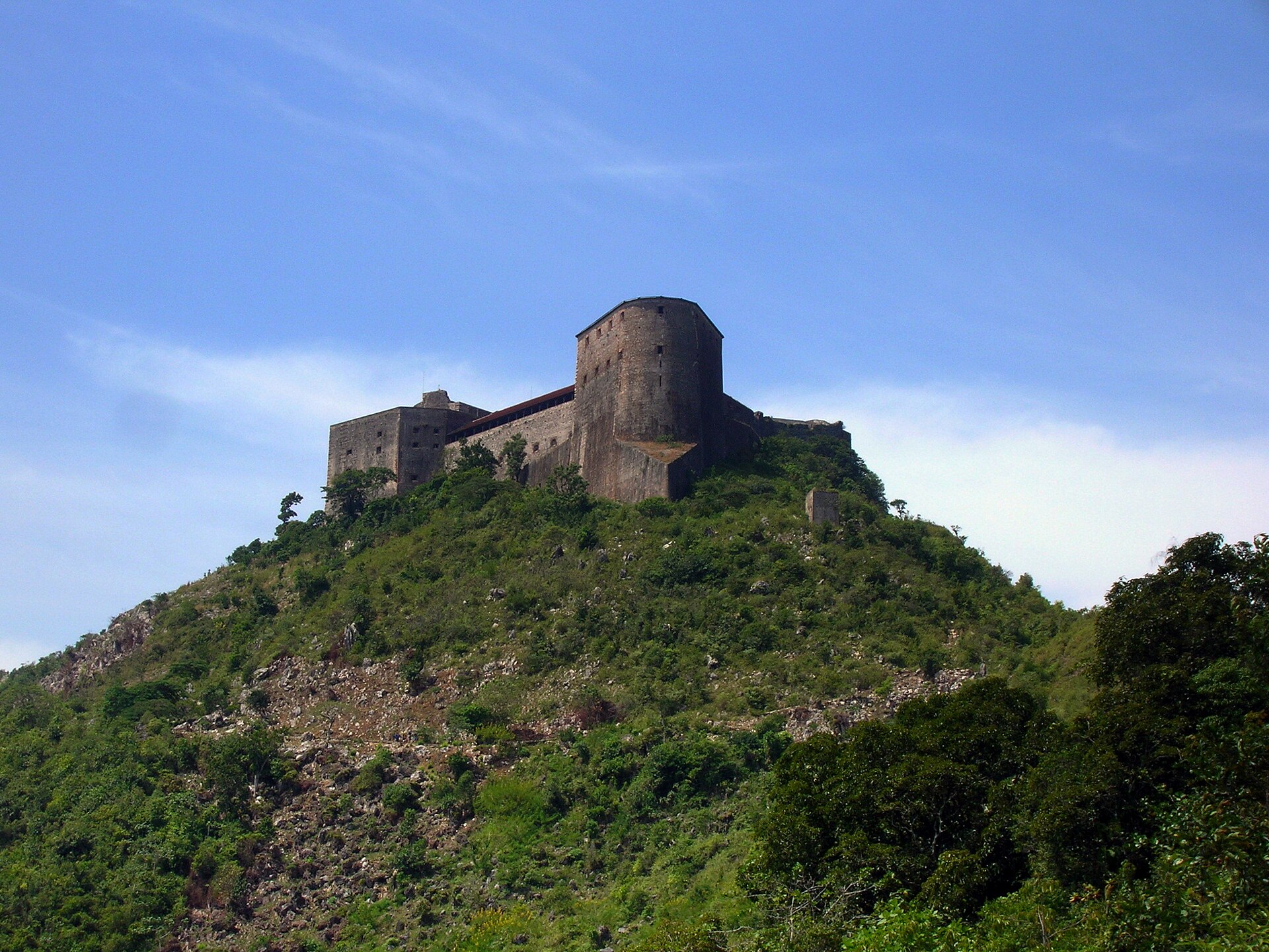
The Citadelle, Sans-Souci and Ramiers preserve the architecture of early independence.
- When was Haiti’s National History Park inscribed by UNESCO?
- In 1982. The listing includes the Citadelle, Sans-Souci and Ramiers.
- Who commissioned the Citadelle Laferrière?
- Henri Christophe, as part of the defensive construction of the early independent state.
- Which department contains Bassin Bleu near Jacmel?
- Sud-Est, in southern Haiti.
More about Haiti: landmarks
The National History Park — Citadel, Sans Souci, Ramiers — became a UNESCO World Heritage site in 1982. The Citadelle Laferrière stands on a mountain above Milot in northern Haiti. Built under Henri Christophe after independence, it formed part of a defensive system intended to resist a possible French return. Sans-Souci Palace lies below near Milot; the Ramiers buildings form the third named component of the site. The monuments reflect both the ambition and the coercive labour of the early post-independence state.
Cap-Haïtien’s streets connect the northern coast with Milot’s monuments. Jacmel’s architecture and crafts offer a different southern history, while Bassin Bleu lies inland near Jacmel in Sud-Est department. Jérémie and Les Cayes anchor different parts of the southern peninsula. Pins in this guide mark approximate learning locations, not routes or evidence that a place is currently accessible. For any journey, consult current official advice and local conditions; the guide makes no promises about openings or safe access.
People & Society of Haiti
Regional communities and a far-reaching diaspora shape Haitian life, literature and public memory.
- What links Haiti with its diaspora?
- Family networks, remittances, travel, language, music, literature and public debate connect communities across borders.
- Who wrote Breath, Eyes, Memory?
- Edwidge Danticat. Her first novel was published in 1994.
- Do all Haitian regions have the same way of life?
- No. Mountain settlements, farming valleys, coastal towns and urban neighbourhoods have different histories and livelihoods.
More about Haiti: people & society
Most Haitians have African ancestry, reflecting the history of enslavement and resistance in Saint-Domingue. The country’s people also carry Indigenous, European and other family histories. Regional identities matter: the north around Cap-Haïtien, the Artibonite Valley, the central plateau and the southern peninsula have different patterns of settlement and work. Rural communities and urban neighbourhoods are linked through markets, family ties, migration and Kreyòl, rather than separated into uniform ways of life.
Haitian communities abroad maintain connections through remittances, visits, music, faith, literature and political debate. Large communities live in the United States, Canada, the Dominican Republic and other countries. Writers such as Edwidge Danticat explore memory, migration and family life; her novel Breath, Eyes, Memory appeared in 1994. Jacques Roumain’s Gouverneurs de la rosée examines rural community and collective action. The diaspora is part of Haitian society without speaking for every resident’s experience.
More countries in North America