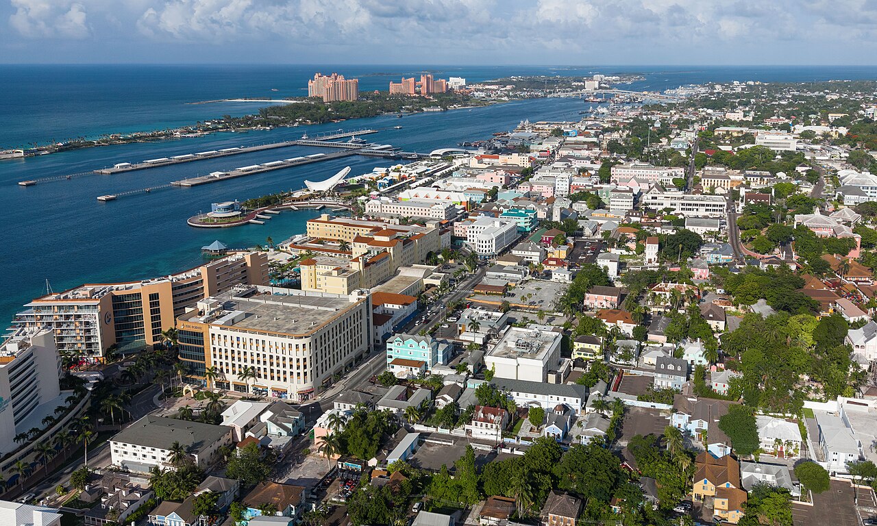
Facts about Bahamas
Explore the Bahamas from Bimini near Florida to the Abacos, Nassau, the Exumas and the flamingo habitats of Inagua. Learn the islands, settlements and deep channels, then discover the histories, food, music and communities behind the map.
- Capital
- Nassau
- Currency
- Bahamian dollar (BSD)
- Official language
- English
- Largest island group
- Andros
- Highest point
- Mount Alvernia, about 63 m
- Independence
- 10 July 1973
Bahamas · 0 of 20 rounds passed
Two timed rounds per topic, 20 seconds a question
Nassau occupies New Providence, with Paradise Island across its harbour. Grand Bahama and the Abacos lie farther north; Bimini faces Florida across the straits. Andros spreads west of the deep Tongue of the Ocean. Eleuthera bends along the eastern bank, while the Exuma chain reaches southeast towards Great Exuma and George Town.
Cat Island, San Salvador, Rum Cay and Long Island lead towards Acklins, Crooked Island, Mayaguana and Inagua. Three maps cover sixteen geographic island groups, twenty settlement centres and six named waters. The groups are separate from administrative districts. Marine geometry follows whole named basins and channels beyond national borders, with the North Atlantic continuing towards Europe and Africa.
Geography of the Bahamas
Low limestone islands and shallow banks stretch southeast from Florida, with deep Atlantic channels between them.
- Are the Bahamas in the Caribbean Sea?
- The islands lie in the Atlantic Ocean, north of the Caribbean Sea. The country is nevertheless part of the wider Caribbean region.
- What is the capital of the Bahamas?
- Nassau, on New Providence. Paradise Island lies across Nassau Harbour and is connected to New Providence by bridges.
- What is the Tongue of the Ocean?
- A deep basin east of Andros, surrounded on three sides by the shallow Great Bahama Bank and open towards the Providence channels in the north.
More about Bahamas: geography
The Bahamas lie in the Atlantic Ocean southeast of Florida and north of Cuba and Hispaniola. The country belongs to the Caribbean region culturally and politically, although its islands are outside the Caribbean Sea. Andros is the largest island group; Nassau, the capital, stands on New Providence. Grand Bahama and the Abacos occupy the north, while Inagua and Mayaguana lie towards the southeastern end.
Shallow carbonate banks create the turquoise water visible from space. Beside them, the Tongue of the Ocean and Exuma Sound descend into deep blue water. The Providence channels connect these basins with the wider Atlantic, and the Straits of Florida separate the western Bahamas from Florida. Mount Alvernia on Cat Island rises to about 63 metres, the country’s highest point. The island map uses sixteen geographic learning groups; these are not administrative districts.
History of the Bahamas
Lucayan communities, Atlantic slavery, colonial settlement and the struggle for majority rule preceded independence in 1973.
- When did the Bahamas become independent?
- On 10 July 1973. The country became an independent Commonwealth state with a parliamentary system and constitutional monarchy.
- Who were the Lucayans?
- The Indigenous inhabitants of the Bahamas at European contact, connected with the wider Taíno world. Enslavement, forced removal and disease devastated their communities.
- What does Majority Rule Day mark?
- The political change of 10 January 1967, when Lynden Pindling’s government took office following the election that brought majority rule.
More about Bahamas: history
Lucayan people, part of the wider Taíno world, inhabited the islands before Columbus arrived in 1492. His first landfall was on an island called Guanahani; its precise modern identification remains debated. Spanish slave raids, forced removal and disease devastated the Lucayan population. English settlers from Bermuda, known as the Eleutheran Adventurers, established a colony on Eleuthera in the late 1640s. Nassau later became a pirate base before royal governor Woodes Rogers arrived in 1718.
After the American Revolution, Loyalists brought enslaved Africans to the islands. Other Africans arrived after being freed from intercepted slave ships. Emancipation began in 1834, followed by the end of the apprenticeship system in 1838. The movement for political equality brought majority rule in 1967 under Lynden Pindling. On 10 July 1973, the Bahamas became independent from Britain while retaining a constitutional monarchy and Commonwealth membership.
English and Bahamian speech
English is official, while Bahamian Creole and Haitian Creole reflect different communities and histories.
- What language is official in the Bahamas?
- English. Bahamian dialect or Bahamian Creole is also widely used in everyday conversation, with variation between speakers and settings.
- Is Bahamian Creole the same as Haitian Creole?
- No. Bahamian Creole is English-based; Haitian Creole is French-based. Both form part of the country’s linguistic life.
- Does everyone speak the same Bahamian dialect?
- Speech varies between islands, generations and social settings. Many speakers move between more local and more formal varieties of English.
More about Bahamas: language
English is the official language and is used in schools, government, news and business. Everyday Bahamian speech includes a local English-based Creole, also called Bahamian dialect or Bahamianese. Its vocabulary, pronunciation and grammar reflect African and English-speaking Atlantic histories. People vary their speech with setting and audience, and usage differs between islands and generations.
Haitian Creole is spoken within communities connected with Haiti, including migrants and their Bahamian-born descendants. It has a different linguistic history from Bahamian Creole and should not be treated as another name for it. Family connections, travel, broadcasting and migration link Bahamian speech with North America and neighbouring islands. Local expressions can carry several meanings, so listening to the situation matters as much as learning a word in isolation.
Junkanoo, music and Bahamian culture
Community groups spend months preparing the costumes, percussion and movement of Junkanoo.
- When are the main Junkanoo parades?
- Traditionally on Boxing Day, 26 December, and New Year’s Day, 1 January. Other Junkanoo events happen at different times of year.
- What instruments feature in rake-and-scrape?
- A scraped carpenter’s saw, accordion and goatskin drum form a characteristic traditional ensemble.
- What does rushing mean in Junkanoo?
- The rhythmic movement of a performing group through the parade, bringing music, dancing and costumes together.
More about Bahamas: culture
Junkanoo joins music, dance, costume-making and community organisation. Major parades take place on Boxing Day and New Year’s Day, with other performances through the year. Groups prepare elaborate costumes decorated with crepe paper and other materials, then rush through the streets with cowbells, whistles, goatskin drums and brass. The tradition has roots in the experiences and creative expression of enslaved Africans and their descendants. UNESCO inscribed Junkanoo on its Representative List in 2023.
Rake-and-scrape uses a different ensemble: an accordion, a scraped carpenter’s saw and a goatskin drum are characteristic instruments. It accompanies social dancing and is strongly associated with the Family Islands, especially Cat Island. Straw work, boatbuilding and sloop regattas connect skill with community life. Churches have also shaped music and social networks, while contemporary visual artists and writers explore island landscapes, memory and national identity.
Tourism, services and island livelihoods
Visitor spending and financial services connect the islands with overseas markets, while storms expose shared vulnerabilities.
- What currency do the Bahamas use?
- The Bahamian dollar, abbreviated BSD, maintained at parity with the US dollar. Sand Dollar is its central-bank-issued digital form.
- What supports the Bahamian economy?
- Tourism and financial services are important sectors. Shipping, salt production, fishing and other local businesses support livelihoods across different islands.
- Which islands were devastated by Hurricane Dorian?
- Abaco and Grand Bahama suffered catastrophic damage in September 2019, with severe consequences for homes, infrastructure and livelihoods.
More about Bahamas: economy
Tourism supports hotels, cruise ports, restaurants, transport and many small businesses. Nassau and Paradise Island attract large visitor flows, while the Family Islands support different combinations of boating, fishing, accommodation and local services. Financial services are another important part of the economy. Freeport connects shipping and industry with Grand Bahama, and Great Inagua is associated with commercial salt production.
The national currency is the Bahamian dollar, code BSD; the central bank maintains parity with the United States dollar. Sand Dollar is a digital form of the Bahamian currency issued by the central bank. Imports supply many everyday goods, and distance between islands raises transport costs. Hurricane Dorian devastated Abaco and Grand Bahama in 2019. Recovery, resilient infrastructure and the effects of climate hazards remain important economic concerns alongside the benefits and pressures of tourism.
Government of the Bahamas
A constitutional monarchy and parliamentary democracy, with elected representatives and an appointed Senate.
- Is the Bahamas an independent country?
- Yes. It has been independent since 1973. Its constitutional monarchy is separate from British government control.
- What are the two parliamentary chambers?
- The elected House of Assembly and the appointed Senate. The sovereign is also formally part of Parliament.
- Are the island groups on this map districts?
- No. They are sixteen geographic learning groups, bringing together related islands and cays rather than representing administrative boundaries.
More about Bahamas: politics
The Bahamas is an independent constitutional monarchy. The monarch of the Bahamas is head of state and is represented locally by a governor-general. The prime minister leads the government and must command the confidence of the elected House of Assembly. Parliament includes the sovereign, the House of Assembly and the appointed Senate. These institutions operate under the constitution that took effect at independence in 1973.
The Progressive Liberal Party and Free National Movement have been the principal parties of the modern era. Local government serves communities across the Family Islands, while New Providence has a different administrative arrangement. The geographic island groups used in this guide are learning categories, separate from districts and parliamentary constituencies. The Bahamas participates in CARICOM, the Commonwealth, the United Nations and the Organization of American States, connecting an Atlantic archipelago with wider Caribbean and international institutions.
Reefs, blue holes and Bahamian wildlife
Mangroves, pine forests, reefs and salt lakes support life above and below the water.
- Where do Bahamian flamingos breed?
- Great Inagua is a major breeding location, with protected habitat in Inagua National Park.
- What does Lucayan National Park protect?
- Underwater caves, mangroves, pine forest and coastal habitats on Grand Bahama, including the area of Gold Rock Beach.
- What is a blue hole?
- A flooded limestone cavity or sinkhole. Bahamian blue holes occur inland as well as in marine settings.
More about Bahamas: nature & wildlife
Bahamian habitats include coral reefs, seagrass meadows, mangroves, pine forests and dry broadleaf woodland. Blue holes are flooded limestone cavities, found both inland and offshore. Andros combines extensive wetlands with blue holes and a reef along its eastern side. On Grand Bahama, Lucayan National Park protects underwater caves, pine forest, mangroves and the coast around Gold Rock Beach.
Inagua National Park protects important flamingo breeding habitat around the salt lakes of Great Inagua. Conservation there depends on wardens, habitat protection and long-term monitoring. The Exuma Cays Land and Sea Park, established in 1958, protects connected island and marine environments. Reefs, conch and other marine populations face pressures from warming, storms and human activity. The famous swimming pigs of Big Major Cay are introduced animals rather than a native wild species.
Conch, souse and Bahamian cooking
Seafood shares the table with peas and rice, baked macaroni, johnny cake and guava duff.
- What is cracked conch?
- Conch meat that has been tenderised, battered and fried. It is one of several familiar ways Bahamians prepare this marine snail.
- What is Bahamian souse?
- A tangy broth, often made with chicken or other meats, lime and vegetables. It is commonly served with johnny cake.
- What is guava duff?
- A Bahamian dessert made with guava folded into dough, cooked and served with a sweet sauce.
More about Bahamas: food & cuisine
Conch is a large marine snail whose firm flesh appears in several Bahamian preparations. Cracked conch is tenderised, battered and fried; conch salad combines chopped conch with citrus, vegetables and pepper. Fish and spiny lobster also feature in coastal cooking. Peas and rice, often made with pigeon peas and a seasoned tomato base, is a familiar accompaniment alongside baked macaroni and other sides.
Souse is a light, tangy broth prepared in versions using chicken or other meats, often with lime and vegetables. Johnny cake is a slightly sweet bread commonly served with savoury dishes. Guava duff folds fruit into dough and is served with a sweet sauce. Coconut water and condensed milk feature in Sky Juice, usually with gin. Recipes vary between households and islands, and fishing seasons and conservation measures help protect the seafood on which many dishes depend.
Bahamian landmarks across the islands
Nassau’s historic streets connect with island forts, pink sand, a hilltop hermitage and deep blue holes.
- Where is the Queen’s Staircase?
- In Nassau on New Providence, near Fort Fincastle. Its limestone passage is one of the capital’s best-known historic sites.
- Which island has Mount Alvernia?
- Cat Island. The hill, also called Como Hill, is the highest point in the Bahamas and carries a small stone hermitage.
- Where is Dean’s Blue Hole?
- On Long Island, near Clarence Town. It is a deep marine sinkhole beside the coast.
More about Bahamas: landmarks
In Nassau, Parliament Square, Fort Fincastle and Fort Charlotte preserve different parts of the colonial city. The Queen’s Staircase cuts through limestone near Fort Fincastle; the site connects the city’s fortifications with the history of enslaved labour. The Pompey Museum in Vendue House addresses slavery and emancipation. Across the harbour, Paradise Island is a separate island linked to New Providence by bridges.
Beyond Nassau, Harbour Island is known for its pink sand beach. Mount Alvernia on Cat Island carries a small stone hermitage above New Bight. Dean’s Blue Hole lies beside the coast of Long Island. Grand Bahama’s Lucayan National Park and the Exuma Cays Land and Sea Park show why a landmark can be an ecosystem as well as a building. Their locations span a wide archipelago, so the map distinguishes settlements and island groups before connecting them with these sights.
Bahamian people and island communities
African heritage, island ties and migration shape communities whose achievements reach far beyond the archipelago.
- Was Sidney Poitier born in the Bahamas?
- He was born in Miami, Florida, to Bahamian parents and grew up in the Bahamas. His Bahamian upbringing was central to his life.
- Who were the Golden Girls?
- The Bahamian women’s sprint relay team celebrated for winning the 4 × 100 metres at the Sydney Olympics in 2000.
- What are the Family Islands?
- A collective name commonly used for the islands beyond the main urban centres. Their communities have distinct histories, livelihoods and local traditions.
More about Bahamas: people & society
Most Bahamians have African ancestry, reflecting the histories of enslavement, emancipation and settlement by liberated Africans. European and other family histories also form part of the country. Haitian migration and communities of Haitian descent are important to contemporary society. Nassau concentrates much of the population and many services, while Family Island communities maintain distinct local identities and connections across the sea.
Bahamian-American actor Sidney Poitier was born in Miami and grew up in the Bahamas; he won the Best Actor Oscar for Lilies of the Field in 1964. Guitarist Joseph Spence brought a distinctive rhythmic and vocal approach to Bahamian music. In sport, the Golden Girls won the women’s 4 × 100 metres relay at Sydney 2000, and Shaunae Miller-Uibo won the women’s 400 metres at Rio 2016 and Tokyo 2020. Everyday boatbuilders, musicians, craftspeople and conservation wardens also sustain the knowledge that gives each island its character.
More countries in North America